Property Record
7315 Us Highway 19 N, Pinellas Park, FL 33781

NEARBY LISTINGS FOR SALE OR LEASE
Property Detail
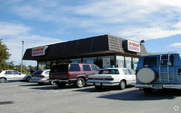
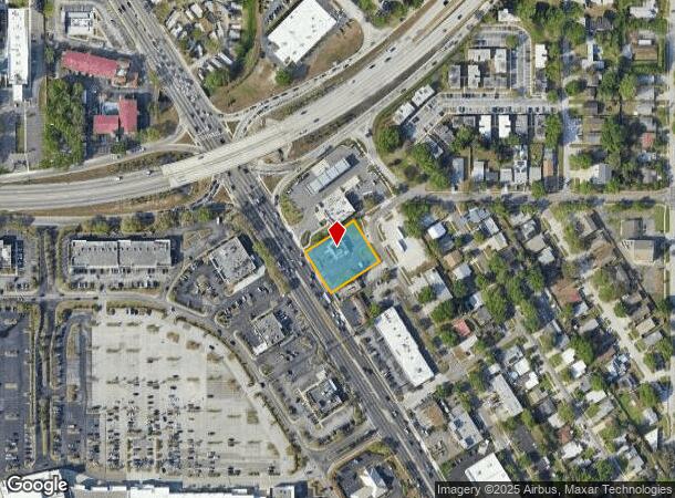
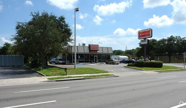
7315 Us Highway 19 N
Tampa-St. Petersburg-Clearwater, FL
Homeland Sub
27-30-16-40914-006-0230
HOMELAND SUB BLK 6, LOTS 53, 54 & 55 & PARTS OF LOTS 23, 24 & 25 ALL BEING DESC AS BEG SE COR OF SD LOT 53 TH S57D 27W 183.03FT TO E R/W OF US 19 TH N31D0650W 150.15FT ALG SD R/W TH N57D2742E 179.15FT TO W R/W OF CYPRESS TERRACE TH S32D3536E 150.07FT
Restaurantdrivein
Pinellas
X
Florida
12103C0208J
23
2024
0.62 AC
2025
Gateway
024601
Tampa/St Petersburg
2,231 SF
DEMOGRAPHICS near 7315 Us Highway 19 N
1 Mile
3 Mile
5 Mile
2024 Total Population
12,782
110,600
266,298
2029 Population
13,102
110,746
266,866
Pop Growth 2024-2029
+ 2.50%
+ 0.13%
+ 0.21%
Average Age
45
43
43
2024 Total Households
5,966
48,702
121,999
HH Growth 2024-2029
+ 2.77%
+ 0.07%
+ 0.07%
Median Household Inc
$51,236
$53,652
$61,234
Avg Household Size
2.10
2.20
2.10
2024 Avg HH Vehicles
1.00
2.00
2.00
Median Home Value
$146,886
$205,973
$247,949
Median Year Built
1976
1970
1971
Nearby Places
Map Layers
Map Styles
 Street
 Aerial
- Restaurants
- Banks
- Shops
- Fitness
- Groceries
PUBLIC TRANSPORTATION
AIRPORT
St Pete-Clearwater International
DRIVE
WALK
Distance
St Pete-Clearwater International
11 min
6.0 mi
Tampa International
DRIVE
WALK
Distance
Tampa International
25 min
16.7 mi
Sarasota/Bradenton International
DRIVE
WALK
Distance
Sarasota/Bradenton International
56 min
37.8 mi
Freight Ports
Port of Tampa Bay
DRIVE
WALK
Distance
Port of Tampa Bay
32 min
20.9 mi
Nearby Properties
Address
Land Use
TOTAL SIZE
Lot Size
Zoning
Address
Land Use
TOTAL SIZE
Lot Size
Zoning
749,164 SF
7.11 AC
Address
Land Use
TOTAL SIZE
Lot Size
Zoning
372,013 SF
10.10 AC
Address
Land Use
TOTAL SIZE
Lot Size
Zoning
447,664 SF
34.44 AC
Address
Land Use
TOTAL SIZE
Lot Size
Zoning
171,420 SF
300.24 AC
M1
Address
Land Use
TOTAL SIZE
Lot Size
Zoning
346,420 SF
17.95 AC
Address
Land Use
TOTAL SIZE
Lot Size
Zoning
372,436 SF
22.30 AC
Address
Land Use
TOTAL SIZE
Lot Size
Zoning
404,063 SF
12.98 AC
Address
Land Use
TOTAL SIZE
Lot Size
Zoning
404,899 SF
35.35 AC
Address
Land Use
TOTAL SIZE
Lot Size
Zoning
358,681 SF
11.70 AC
Address
Land Use
TOTAL SIZE
Lot Size
Zoning
240,736 SF
58.40 AC
Address
Land Use
TOTAL SIZE
Lot Size
Zoning
402,681 SF
18.40 AC
Address
Land Use
TOTAL SIZE
Lot Size
Zoning
359,527 SF
19.65 AC
Address
Land Use
TOTAL SIZE
Lot Size
Zoning
324,579 SF
16.97 AC
Address
Land Use
TOTAL SIZE
Lot Size
Zoning
309,526 SF
36.85 AC
C2
Address
Land Use
TOTAL SIZE
Lot Size
Zoning
444,770 SF
14.95 AC
Address
Land Use
TOTAL SIZE
Lot Size
Zoning
464,493 SF
17.41 AC
Address
Land Use
TOTAL SIZE
Lot Size
Zoning
572,006 SF
13.01 AC
Address
Land Use
TOTAL SIZE
Lot Size
Zoning
300,546 SF
6.49 AC
Address
Land Use
TOTAL SIZE
Lot Size
Zoning
423,776 SF
20.91 AC
Address
Land Use
TOTAL SIZE
Lot Size
Zoning
170,146 SF
17.78 AC
Address
Land Use
TOTAL SIZE
Lot Size
Zoning
240,392 SF
58.32 AC
Address
Land Use
TOTAL SIZE
Lot Size
Zoning
267,649 SF
17.86 AC
Address
Land Use
TOTAL SIZE
Lot Size
Zoning
174,071 SF
7.53 AC
Address
Land Use
TOTAL SIZE
Lot Size
Zoning
288,272 SF
12.34 AC
Address
Land Use
TOTAL SIZE
Lot Size
Zoning
298,116 SF
12.34 AC
Address
Land Use
TOTAL SIZE
Lot Size
Zoning
258,722 SF
11.04 AC
Address
Land Use
TOTAL SIZE
Lot Size
Zoning
281,993 SF
85.13 AC
Address
Land Use
TOTAL SIZE
Lot Size
Zoning
193,194 SF
13.53 AC
Address
Land Use
TOTAL SIZE
Lot Size
Zoning
360,137 SF
37.64 AC
AE
Address
Land Use
TOTAL SIZE
Lot Size
Zoning
244,896 SF
28.70 AC
The World's #1 Commercial Real Estate Marketplace
Connect with us
© 2025 CoStar Group
The information above has been obtained from sources believed reliable. While we do not doubt its accuracy we have not verified it and make no guarantee, warranty or representation about it. It is your responsibility to independently confirm its accuracy and completeness. Any projections, opinions, assumptions, or estimates used are for example only and do not represent the current or future performance of the property. The value of this transaction to you depends on tax and other factors which should be evaluated by your tax, financial, and legal advisors. You and your advisors should conduct a careful, independent investigation of the property to determine to your satisfaction the suitability of the property for your needs.