Property Record
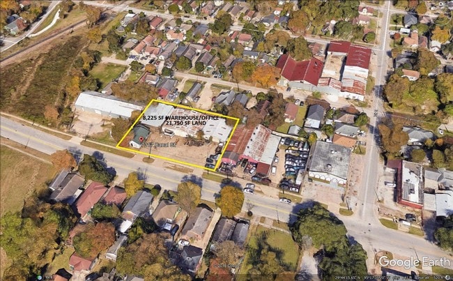
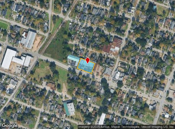
7317 Canal St, Houston, TX 77011
This Property Is For Sale
NEARBY LISTINGS FOR SALE OR LEASE
Property Detail
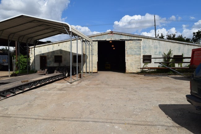
7317 Canal St
Houston-The Woodlands-Sugar Land, TX
Magnolia Park
0251500000004
Harris
Sfr
Texas
X
0.52 AC
48201C0885N
Southeast Outer Loop
8,484 SF
Houston
DEMOGRAPHICS near 7317 Canal St
1 Mile
3 Mile
5 Mile
2024 Total Population
16,442
101,558
320,235
2029 Population
16,862
104,579
330,809
Pop Growth 2024-2029
+ 2.55%
+ 2.97%
+ 3.30%
Average Age
38
37
37
2024 Total Households
5,655
35,711
111,774
HH Growth 2024-2029
+ 2.46%
+ 3.01%
+ 3.70%
Median Household Inc
$36,252
$38,438
$43,896
Avg Household Size
2.80
2.80
2.60
2024 Avg HH Vehicles
2.00
2.00
2.00
Median Home Value
$128,436
$151,869
$160,413
Median Year Built
1948
1954
1962
Nearby Places
Map Layers
Map Styles
 Street
 Aerial
- Restaurants
- Banks
- Shops
- Fitness
- Groceries
PUBLIC TRANSPORTATION
TRANSIT/SUBWAY
Magnolia Park Transit Center Wb (METRORAIL GREEN LINE - Metropolitan Transit Authority of Harris County)
DRIVE
WALK
Distance
Magnolia Park Transit Center Wb (METRORAIL GREEN LINE - Metropolitan Transit Authority of Harris County)
2 min
14 min
0.7 mi
Magnolia Park Transit Center Eb (METRORAIL GREEN LINE - Metropolitan Transit Authority of Harris County)
DRIVE
WALK
Distance
Magnolia Park Transit Center Eb (METRORAIL GREEN LINE - Metropolitan Transit Authority of Harris County)
2 min
14 min
0.7 mi
Cesar Chavez / 67Th St Eb (METRORAIL GREEN LINE - Metropolitan Transit Authority of Harris County)
DRIVE
WALK
Distance
Cesar Chavez / 67Th St Eb (METRORAIL GREEN LINE - Metropolitan Transit Authority of Harris County)
2 min
20 min
1.0 mi
COMMUTER RAIL
Houston (Sunset Limited - Amtrak)
DRIVE
WALK
Distance
Houston (Sunset Limited - Amtrak)
11 min
5.6 mi
AIRPORT
William P Hobby
DRIVE
WALK
Distance
William P Hobby
19 min
8.6 mi
George Bush Intcntl/Houston
DRIVE
WALK
Distance
George Bush Intcntl/Houston
32 min
21.9 mi
Freight Ports
Port of Houston
DRIVE
WALK
Distance
Port of Houston
13 min
5.4 mi
Nearby Properties
Address
Land Use
TOTAL SIZE
Lot Size
Zoning
Address
Land Use
TOTAL SIZE
Lot Size
Zoning
108.84 AC
Address
Land Use
TOTAL SIZE
Lot Size
Zoning
100.26 AC
Address
Land Use
TOTAL SIZE
Lot Size
Zoning
1,392,720 SF
83.75 AC
Address
Land Use
TOTAL SIZE
Lot Size
Zoning
2,275,058 SF
24.47 AC
Address
Land Use
TOTAL SIZE
Lot Size
Zoning
403,242 SF
46.18 AC
Address
Land Use
TOTAL SIZE
Lot Size
Zoning
1,171,276 SF
44.19 AC
Address
Land Use
TOTAL SIZE
Lot Size
Zoning
242,936 SF
Address
Land Use
TOTAL SIZE
Lot Size
Zoning
198,023 SF
17.87 AC
Address
Land Use
TOTAL SIZE
Lot Size
Zoning
33.97 AC
Address
Land Use
TOTAL SIZE
Lot Size
Zoning
901,984 SF
59.37 AC
Address
Land Use
TOTAL SIZE
Lot Size
Zoning
504,018 SF
37.16 AC
Address
Land Use
TOTAL SIZE
Lot Size
Zoning
785,097 SF
27.77 AC
Address
Land Use
TOTAL SIZE
Lot Size
Zoning
107.07 AC
Address
Land Use
TOTAL SIZE
Lot Size
Zoning
Address
Land Use
TOTAL SIZE
Lot Size
Zoning
985,528 SF
22.64 AC
Address
Land Use
TOTAL SIZE
Lot Size
Zoning
923,370 SF
13.76 AC
Address
Land Use
TOTAL SIZE
Lot Size
Zoning
232,915 SF
7.89 AC
Address
Land Use
TOTAL SIZE
Lot Size
Zoning
267,844 SF
10.98 AC
Address
Land Use
TOTAL SIZE
Lot Size
Zoning
194,296 SF
15.13 AC
Address
Land Use
TOTAL SIZE
Lot Size
Zoning
595,069 SF
17.77 AC
Address
Land Use
TOTAL SIZE
Lot Size
Zoning
238,125 SF
12.73 AC
Address
Land Use
TOTAL SIZE
Lot Size
Zoning
78,073 SF
5.45 AC
Address
Land Use
TOTAL SIZE
Lot Size
Zoning
207,196 SF
16.55 AC
Address
Land Use
TOTAL SIZE
Lot Size
Zoning
175,172 SF
8.81 AC
Address
Land Use
TOTAL SIZE
Lot Size
Zoning
241,999 SF
8.46 AC
Address
Land Use
TOTAL SIZE
Lot Size
Zoning
54,077 SF
5.06 AC
Address
Land Use
TOTAL SIZE
Lot Size
Zoning
67,891 SF
51.16 AC
Address
Land Use
TOTAL SIZE
Lot Size
Zoning
229,465 SF
9.80 AC
Address
Land Use
TOTAL SIZE
Lot Size
Zoning
Address
Land Use
TOTAL SIZE
Lot Size
Zoning
223,514 SF
9.23 AC
The World's #1 Commercial Real Estate Marketplace
Connect with us
© 2025 CoStar Group
The information above has been obtained from sources believed reliable. While we do not doubt its accuracy we have not verified it and make no guarantee, warranty or representation about it. It is your responsibility to independently confirm its accuracy and completeness. Any projections, opinions, assumptions, or estimates used are for example only and do not represent the current or future performance of the property. The value of this transaction to you depends on tax and other factors which should be evaluated by your tax, financial, and legal advisors. You and your advisors should conduct a careful, independent investigation of the property to determine to your satisfaction the suitability of the property for your needs.