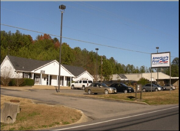
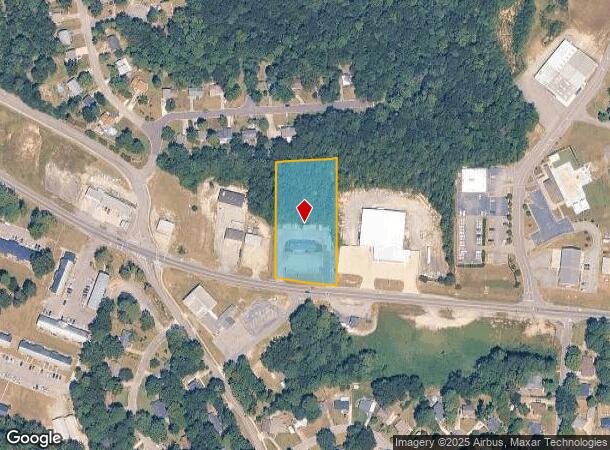
Property Record
7318 Parkway Dr, Leeds, AL 35094
NEARBY LISTINGS FOR SALE OR LEASE
-
-
View all Leeds listings for sale on LoopNet.com
Property Detail
7318 Parkway Dr
25-00-20-2-001-041.001
COM AT NE COR OF NW1/4 OF NW 1/4 SEC 20 TP 17 R 1E TH S 895.7 FT TH W 100 FT TH S 66.5 FT TH ELY 399.8 FT TO POB TH S 401.8 FT TH NWLY 200 FT TH N 370 FT(S) TH E 200 FT TO POB SECT 20 TWSP 17S RANGE 1E
Officebuilding
Jefferson
X
Alabama
01073C0437H
1.77 AC
2023
Trussville
2024
Birmingham
011002
Birmingham-Hoover, AL
2,524 SF
DEMOGRAPHICS near 7318 Parkway Dr
1 Mile
3 Mile
5 Mile
2024 Total Population
3,641
11,602
27,411
2029 Population
3,553
11,504
27,519
Pop Growth 2024-2029
(2.42%)
(0.84%)
+ 0.39%
Average Age
40
40
40
2024 Total Households
1,495
4,645
10,633
HH Growth 2024-2029
(2.41%)
(0.86%)
+ 0.42%
Median Household Inc
$48,778
$61,250
$66,511
Avg Household Size
2.40
2.40
2.50
2024 Avg HH Vehicles
2.00
2.00
2.00
Median Home Value
$177,447
$182,158
$194,131
Median Year Built
1972
1978
1989
Nearby Places
Map Layers
Map Styles
 Street
 Aerial
- Restaurants
- Banks
- Shops
- Fitness
- Groceries
PUBLIC TRANSPORTATION
AIRPORT
Birmingham-Shuttlesworth International
DRIVE
WALK
Distance
Birmingham-Shuttlesworth International
18 min
13.3 mi
Freight Ports
Port of Mobile
DRIVE
WALK
Distance
Port of Mobile
289 min
264.6 mi
Nearby Properties
Address
Land Use
TOTAL SIZE
Lot Size
Zoning
Address
Land Use
TOTAL SIZE
Lot Size
Zoning
356,967 SF
34.71 AC
I3S&
Address
Land Use
TOTAL SIZE
Lot Size
Zoning
146,331 SF
161 AC
I3S&
Address
Land Use
TOTAL SIZE
Lot Size
Zoning
146,749 SF
23.99 AC
B2
Address
Land Use
TOTAL SIZE
Lot Size
Zoning
52,828 SF
12.70 AC
B2
Address
Land Use
TOTAL SIZE
Lot Size
Zoning
28,666 SF
4.41 AC
B2
Address
Land Use
TOTAL SIZE
Lot Size
Zoning
59,487 SF
9.20 AC
B2-R
Address
Land Use
TOTAL SIZE
Lot Size
Zoning
22.57 AC
I3
Address
Land Use
TOTAL SIZE
Lot Size
Zoning
82,025 SF
Address
Land Use
TOTAL SIZE
Lot Size
Zoning
184,068 SF
62 AC
M2
Address
Land Use
TOTAL SIZE
Lot Size
Zoning
243,530 SF
29 AC
M2
Address
Land Use
TOTAL SIZE
Lot Size
Zoning
77,822 SF
6.12 AC
R-3
Address
Land Use
TOTAL SIZE
Lot Size
Zoning
139,086 SF
15 AC
M2
Address
Land Use
TOTAL SIZE
Lot Size
Zoning
6,000 SF
8.30 AC
Address
Land Use
TOTAL SIZE
Lot Size
Zoning
122,300 SF
5.70 AC
M2-I
Address
Land Use
TOTAL SIZE
Lot Size
Zoning
80,643 SF
4.22 AC
R3
Address
Land Use
TOTAL SIZE
Lot Size
Zoning
82,256 SF
6.60 AC
B-2
Address
Land Use
TOTAL SIZE
Lot Size
Zoning
12,960 SF
4.45 AC
B2
Address
Land Use
TOTAL SIZE
Lot Size
Zoning
113,550 SF
10 AC
M-2
Address
Land Use
TOTAL SIZE
Lot Size
Zoning
14.18 AC
B2
Address
Land Use
TOTAL SIZE
Lot Size
Zoning
141,610 SF
4.40 AC
M1-R
Address
Land Use
TOTAL SIZE
Lot Size
Zoning
6.66 AC
Address
Land Use
TOTAL SIZE
Lot Size
Zoning
33,227 SF
3.50 AC
R2
Address
Land Use
TOTAL SIZE
Lot Size
Zoning
19,600 SF
2.25 AC
Address
Land Use
TOTAL SIZE
Lot Size
Zoning
6.40 AC
B2
Address
Land Use
TOTAL SIZE
Lot Size
Zoning
81,500 SF
9.80 AC
M1-R
Address
Land Use
TOTAL SIZE
Lot Size
Zoning
22,330 SF
2.30 AC
Address
Land Use
TOTAL SIZE
Lot Size
Zoning
65,960 SF
4 AC
B2
Address
Land Use
TOTAL SIZE
Lot Size
Zoning
38,500 SF
4 AC
M2/Y
The World's #1 Commercial Real Estate Marketplace
Connect with us
© 2025 CoStar Group
The information above has been obtained from sources believed reliable. While we do not doubt its accuracy we have not verified it and make no guarantee, warranty or representation about it. It is your responsibility to independently confirm its accuracy and completeness. Any projections, opinions, assumptions, or estimates used are for example only and do not represent the current or future performance of the property. The value of this transaction to you depends on tax and other factors which should be evaluated by your tax, financial, and legal advisors. You and your advisors should conduct a careful, independent investigation of the property to determine to your satisfaction the suitability of the property for your needs.