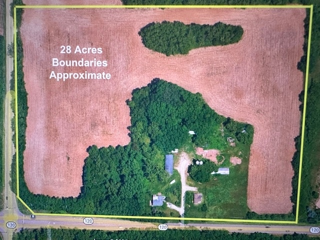
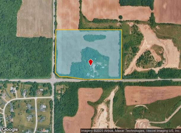
Property Record
7318 W Il Route 120, Mchenry, IL 60050
NEARBY LISTINGS FOR SALE OR LEASE
-
-
View all Mchenry listings for sale on LoopNet.com
Property Detail
7318 W Il Route 120
Chicago-Naperville-Elgin, IL-IN
McHenry
09-19-400-013
Illinois
Residentialnec
28.31 AC
X
Far Northwest
17111C0205J
Chicago
2,136 SF
DEMOGRAPHICS near 7318 W Il Route 120
1 Mile
3 Mile
5 Mile
2024 Total Population
1,651
22,965
50,777
2029 Population
1,665
23,128
51,163
Pop Growth 2024-2029
+ 0.85%
+ 0.71%
+ 0.76%
Average Age
41
41
41
2024 Total Households
604
8,651
19,557
HH Growth 2024-2029
+ 0.83%
+ 0.74%
+ 0.76%
Median Household Inc
$103,049
$79,938
$82,830
Avg Household Size
2.70
2.60
2.50
2024 Avg HH Vehicles
2.00
2.00
2.00
Median Home Value
$187,905
$193,484
$219,424
Median Year Built
1985
1979
1985
Nearby Places
Map Layers
Map Styles
 Street
 Aerial
- Restaurants
- Banks
- Shops
- Fitness
- Groceries
PUBLIC TRANSPORTATION
COMMUTER RAIL
Mchenry Station (Union Pacific Northwest Line - Northeast Illinois Regional Commuter Railroad (Metra))
DRIVE
WALK
Distance
Mchenry Station (Union Pacific Northwest Line - Northeast Illinois Regional Commuter Railroad (Metra))
7 min
3.8 mi
Woodstock Station (Union Pacific Northwest Line - Northeast Illinois Regional Commuter Railroad (Metra))
DRIVE
WALK
Distance
Woodstock Station (Union Pacific Northwest Line - Northeast Illinois Regional Commuter Railroad (Metra))
10 min
7.0 mi
Freight Ports
Port Milwaukee
DRIVE
WALK
Distance
Port Milwaukee
90 min
67.9 mi
SALE & LEASE HISTORY
LISTING DATE
SALE/LEASE

Sep 24, 2016
For Sale
Sep 13, 2017
For Sale
May 12, 2025
For Sale
Nearby Properties
Address
Land Use
TOTAL SIZE
Lot Size
Zoning
Address
Land Use
TOTAL SIZE
Lot Size
Zoning
17,640 SF
2 AC
Address
Land Use
TOTAL SIZE
Lot Size
Zoning
6,300 SF
5 AC
Address
Land Use
TOTAL SIZE
Lot Size
Zoning
2,800 SF
1.98 AC
Address
Land Use
TOTAL SIZE
Lot Size
Zoning
40,296 SF
1 AC
Address
Land Use
TOTAL SIZE
Lot Size
Zoning
7.81 AC
Address
Land Use
TOTAL SIZE
Lot Size
Zoning
11,294 SF
2 AC
Address
Land Use
TOTAL SIZE
Lot Size
Zoning
8,627 SF
1 AC
Address
Land Use
TOTAL SIZE
Lot Size
Zoning
1.93 AC
Address
Land Use
TOTAL SIZE
Lot Size
Zoning
14,302 SF
1 AC
Address
Land Use
TOTAL SIZE
Lot Size
Zoning
13,248 SF
1.21 AC
Address
Land Use
TOTAL SIZE
Lot Size
Zoning
7,184 SF
0.83 AC
Address
Land Use
TOTAL SIZE
Lot Size
Zoning
10,625 SF
0.17 AC
Address
Land Use
TOTAL SIZE
Lot Size
Zoning
12,900 SF
0.52 AC
Address
Land Use
TOTAL SIZE
Lot Size
Zoning
Address
Land Use
TOTAL SIZE
Lot Size
Zoning
2.79 AC
Address
Land Use
TOTAL SIZE
Lot Size
Zoning
15,912 SF
2.01 AC
Address
Land Use
TOTAL SIZE
Lot Size
Zoning
18,060 SF
0.28 AC
Address
Land Use
TOTAL SIZE
Lot Size
Zoning
3,434 SF
0.75 AC
Address
Land Use
TOTAL SIZE
Lot Size
Zoning
12,248 SF
1.20 AC
Address
Land Use
TOTAL SIZE
Lot Size
Zoning
16,519 SF
1.72 AC
Address
Land Use
TOTAL SIZE
Lot Size
Zoning
12,320 SF
2.44 AC
Address
Land Use
TOTAL SIZE
Lot Size
Zoning
8.96 AC
Address
Land Use
TOTAL SIZE
Lot Size
Zoning
9.90 AC
Address
Land Use
TOTAL SIZE
Lot Size
Zoning
39.30 AC
Address
Land Use
TOTAL SIZE
Lot Size
Zoning
9,108 SF
8.86 AC
Address
Land Use
TOTAL SIZE
Lot Size
Zoning
9,350 SF
1.59 AC
Address
Land Use
TOTAL SIZE
Lot Size
Zoning
Address
Land Use
TOTAL SIZE
Lot Size
Zoning
13,213 SF
0.58 AC
Address
Land Use
TOTAL SIZE
Lot Size
Zoning
8,000 SF
0.28 AC
Address
Land Use
TOTAL SIZE
Lot Size
Zoning
14,256 SF
1 AC
The World's #1 Commercial Real Estate Marketplace
Connect with us
© 2026 CoStar Group
The information above has been obtained from sources believed reliable. While we do not doubt its accuracy we have not verified it and make no guarantee, warranty or representation about it. It is your responsibility to independently confirm its accuracy and completeness. Any projections, opinions, assumptions, or estimates used are for example only and do not represent the current or future performance of the property. The value of this transaction to you depends on tax and other factors which should be evaluated by your tax, financial, and legal advisors. You and your advisors should conduct a careful, independent investigation of the property to determine to your satisfaction the suitability of the property for your needs.