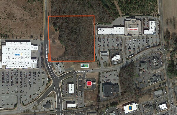
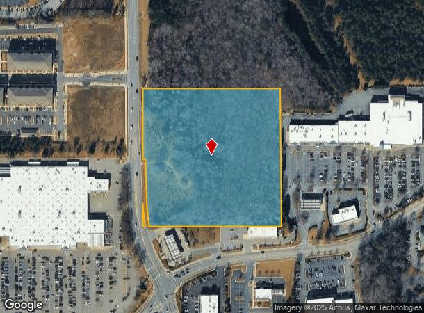
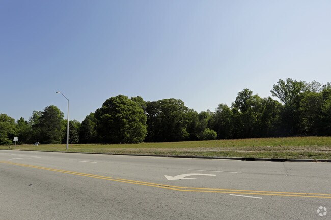
Property Record
750 N Judd Pkwy Ne, Fuquay Varina, NC 27526

NEARBY LISTINGS FOR SALE OR LEASE
Property Detail
750 N Judd Pkwy Ne
Raleigh, NC
Charles W Daniel
0667.04-51-9821-000
GR PT PROP LOIS G DANIEL HEIRS PROP BM2
Vacantlandnec
Wake
X
North Carolina
3720066700K
9.02 AC
2025
Southwest Wake County
2025
Raleigh/Durham
053105
DEMOGRAPHICS near 750 N Judd Pkwy Ne
1 Mile
3 Mile
5 Mile
2024 Total Population
5,455
47,913
91,741
2029 Population
6,098
53,131
101,035
Pop Growth 2024-2029
+ 11.79%
+ 10.89%
+ 10.13%
Average Age
41
39
39
2024 Total Households
2,093
17,299
32,187
HH Growth 2024-2029
+ 11.75%
+ 10.86%
+ 10.14%
Median Household Inc
$80,409
$88,890
$98,587
Avg Household Size
2.60
2.70
2.80
2024 Avg HH Vehicles
2.00
2.00
2.00
Median Home Value
$306,285
$345,671
$373,497
Median Year Built
2005
2006
2004
Nearby Places
- Restaurants
- Banks
- Shops
- Fitness
- Groceries
PUBLIC TRANSPORTATION
AIRPORT
Raleigh-Durham International
DRIVE
WALK
Distance
Raleigh-Durham International
39 min
28.6 mi
SALE & LEASE HISTORY
LISTING DATE
SALE/LEASE

May 02, 2017
For Sale
Aug 27, 2020
For Sale
Nearby Properties
Address
Land Use
TOTAL SIZE
Lot Size
Zoning
Address
Land Use
TOTAL SIZE
Lot Size
Zoning
435,576 SF
29.37 AC
RHD-C
Address
Land Use
TOTAL SIZE
Lot Size
Zoning
378,367 SF
26.21 AC
RHD-C
Address
Land Use
TOTAL SIZE
Lot Size
Zoning
311,701 SF
19.97 AC
RHD
Address
Land Use
TOTAL SIZE
Lot Size
Zoning
244,266 SF
11.74 AC
PUD
Address
Land Use
TOTAL SIZE
Lot Size
Zoning
201,371 SF
9.68 AC
O&I
Address
Land Use
TOTAL SIZE
Lot Size
Zoning
254,280 SF
65.10 AC
OI-CZ
Address
Land Use
TOTAL SIZE
Lot Size
Zoning
207,800 SF
7.18 AC
NMU
Address
Land Use
TOTAL SIZE
Lot Size
Zoning
346,384 SF
56.12 AC
HI
Address
Land Use
TOTAL SIZE
Lot Size
Zoning
161,685 SF
14.55 AC
O&I
Address
Land Use
TOTAL SIZE
Lot Size
Zoning
158,656 SF
10.31 AC
CC-CZ
Address
Land Use
TOTAL SIZE
Lot Size
Zoning
68,452 SF
50.57 AC
OI-CZD
Address
Land Use
TOTAL SIZE
Lot Size
Zoning
237,750 SF
41.18 AC
RLI
Address
Land Use
TOTAL SIZE
Lot Size
Zoning
290,054 SF
34.18 AC
HI
Address
Land Use
TOTAL SIZE
Lot Size
Zoning
149,526 SF
10.91 AC
HI
Address
Land Use
TOTAL SIZE
Lot Size
Zoning
83,208 SF
27.68 AC
O&I
Address
Land Use
TOTAL SIZE
Lot Size
Zoning
101,680 SF
2.36 AC
UMU
Address
Land Use
TOTAL SIZE
Lot Size
Zoning
340,556 SF
33.92 AC
RLI
Address
Land Use
TOTAL SIZE
Lot Size
Zoning
83,283 SF
14.79 AC
GC
Address
Land Use
TOTAL SIZE
Lot Size
Zoning
99,307 SF
10.91 AC
CC
Address
Land Use
TOTAL SIZE
Lot Size
Zoning
79,212 SF
4.10 AC
CC-CZ
Address
Land Use
TOTAL SIZE
Lot Size
Zoning
135,108 SF
4.12 AC
RLI
Address
Land Use
TOTAL SIZE
Lot Size
Zoning
82,857 SF
9.56 AC
O&I
Address
Land Use
TOTAL SIZE
Lot Size
Zoning
111,627 SF
2.55 AC
CC
Address
Land Use
TOTAL SIZE
Lot Size
Zoning
112,700 SF
15.84 AC
HI
Address
Land Use
TOTAL SIZE
Lot Size
Zoning
57,062 SF
10.81 AC
OI-CZ
Address
Land Use
TOTAL SIZE
Lot Size
Zoning
149,975 SF
18.73 AC
GC
Address
Land Use
TOTAL SIZE
Lot Size
Zoning
108,162 SF
4.18 AC
GC-CZ
Address
Land Use
TOTAL SIZE
Lot Size
Zoning
73,410 SF
21.97 AC
O&I
Address
Land Use
TOTAL SIZE
Lot Size
Zoning
183,855 SF
19.67 AC
HI
Address
Land Use
TOTAL SIZE
Lot Size
Zoning
1.83 AC
RMU
The World's #1 Commercial Real Estate Marketplace
Connect with us
© 2025 CoStar Group
The information above has been obtained from sources believed reliable. While we do not doubt its accuracy we have not verified it and make no guarantee, warranty or representation about it. It is your responsibility to independently confirm its accuracy and completeness. Any projections, opinions, assumptions, or estimates used are for example only and do not represent the current or future performance of the property. The value of this transaction to you depends on tax and other factors which should be evaluated by your tax, financial, and legal advisors. You and your advisors should conduct a careful, independent investigation of the property to determine to your satisfaction the suitability of the property for your needs.