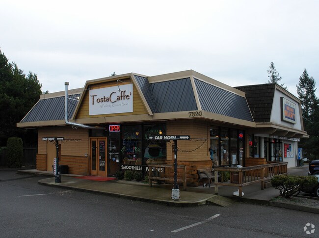
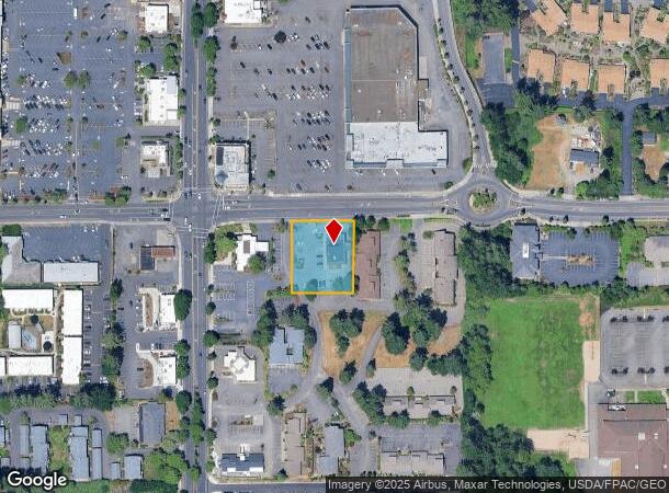
Property Record
7320 40Th St W, University Place, WA 98466


NEARBY LISTINGS FOR SALE OR LEASE
Property Detail
7320 40Th St W
Seattle-Tacoma-Bellevue, WA
Short Plat No 78 791
022015-8012
SECTION 15 TOWNSHIP 20 RANGE 02 QUARTER 42 : L 1 OF S P 78-191 OUT OF 4-091 SEG L-1867 SF ES (DCJEAEMS3-16-82) ETN 4533274 PROBLEM WITH LEGAL WORKED ON INTENT 07/08/2020MC
Storebuilding
Pierce
X
Washington
53053C0281E
1
2024
0.59 AC
2025
Univ. Place/Lakewood
072311
Seattle/Puget Sound
2,800 SF
DEMOGRAPHICS near 7320 40Th St W
1 Mile
3 Mile
5 Mile
2024 Total Population
16,646
102,476
258,434
2029 Population
17,233
106,016
266,743
Pop Growth 2024-2029
+ 3.53%
+ 3.45%
+ 3.22%
Average Age
41
40
40
2024 Total Households
6,720
42,566
105,542
HH Growth 2024-2029
+ 3.63%
+ 3.59%
+ 3.38%
Median Household Inc
$88,524
$75,293
$76,726
Avg Household Size
2.40
2.30
2.30
2024 Avg HH Vehicles
2.00
2.00
2.00
Median Home Value
$517,977
$472,129
$457,714
Median Year Built
1979
1978
1972
Nearby Places
Map Layers
Map Styles
 Street
 Aerial
- Restaurants
- Banks
- Shops
- Fitness
- Groceries
PUBLIC TRANSPORTATION
COMMUTER RAIL
DRIVE
WALK
Distance
8 min
3.4 mi
DRIVE
WALK
Distance
15 min
6.1 mi
AIRPORT
Seattle-Tacoma International
DRIVE
WALK
Distance
Seattle-Tacoma International
45 min
27.0 mi
Freight Ports
Port of Tacoma
DRIVE
WALK
Distance
Port of Tacoma
18 min
8.6 mi
Nearby Properties
Address
Land Use
TOTAL SIZE
Lot Size
Zoning
Address
Land Use
TOTAL SIZE
Lot Size
Zoning
618,098 SF
150.67 AC
CCX
Address
Land Use
TOTAL SIZE
Lot Size
Zoning
87,528 SF
224.76 AC
R1
Address
Land Use
TOTAL SIZE
Lot Size
Zoning
412,549 SF
56.87 AC
R1
Address
Land Use
TOTAL SIZE
Lot Size
Zoning
309,156 SF
33.79 AC
M2
Address
Land Use
TOTAL SIZE
Lot Size
Zoning
296,154 SF
46.83 AC
R2
Address
Land Use
TOTAL SIZE
Lot Size
Zoning
335,336 SF
31.84 AC
RCX
Address
Land Use
TOTAL SIZE
Lot Size
Zoning
358,200 SF
27.25 AC
R3
Address
Land Use
TOTAL SIZE
Lot Size
Zoning
196,380 SF
8.33 AC
R4L
Address
Land Use
TOTAL SIZE
Lot Size
Zoning
222,641 SF
15.41 AC
R4L
Address
Land Use
TOTAL SIZE
Lot Size
Zoning
8,177 SF
343.30 AC
R1
Address
Land Use
TOTAL SIZE
Lot Size
Zoning
100,856 SF
19.76 AC
R2
Address
Land Use
TOTAL SIZE
Lot Size
Zoning
244,143 SF
11.79 AC
MF3
Address
Land Use
TOTAL SIZE
Lot Size
Zoning
211,786 SF
16.84 AC
MF2
Address
Land Use
TOTAL SIZE
Lot Size
Zoning
149,844 SF
11.50 AC
MF
Address
Land Use
TOTAL SIZE
Lot Size
Zoning
223,447 SF
40.44 AC
RCX
Address
Land Use
TOTAL SIZE
Lot Size
Zoning
254,934 SF
5.02 AC
MF
Address
Land Use
TOTAL SIZE
Lot Size
Zoning
329,594 SF
10.60 AC
C2
Address
Land Use
TOTAL SIZE
Lot Size
Zoning
67,612 SF
2.93 AC
TAC
Address
Land Use
TOTAL SIZE
Lot Size
Zoning
149,364 SF
35.69 AC
PI
Address
Land Use
TOTAL SIZE
Lot Size
Zoning
208,780 SF
10.16 AC
R4L
Address
Land Use
TOTAL SIZE
Lot Size
Zoning
332,140 SF
9.23 AC
M2
Address
Land Use
TOTAL SIZE
Lot Size
Zoning
150,896 SF
11.63 AC
R3
Address
Land Use
TOTAL SIZE
Lot Size
Zoning
61.20 AC
M2
Address
Land Use
TOTAL SIZE
Lot Size
Zoning
117,608 SF
10.11 AC
R3
Address
Land Use
TOTAL SIZE
Lot Size
Zoning
119,926 SF
10.87 AC
HM
Address
Land Use
TOTAL SIZE
Lot Size
Zoning
109,674 SF
2.49 AC
R4L
Address
Land Use
TOTAL SIZE
Lot Size
Zoning
160,514 SF
15.61 AC
MF2
Address
Land Use
TOTAL SIZE
Lot Size
Zoning
102,723 SF
16.16 AC
R4
Address
Land Use
TOTAL SIZE
Lot Size
Zoning
133,660 SF
6.79 AC
MF
Address
Land Use
TOTAL SIZE
Lot Size
Zoning
295,421 SF
15.92 AC
The World's #1 Commercial Real Estate Marketplace
Connect with us
© 2025 CoStar Group
The information above has been obtained from sources believed reliable. While we do not doubt its accuracy we have not verified it and make no guarantee, warranty or representation about it. It is your responsibility to independently confirm its accuracy and completeness. Any projections, opinions, assumptions, or estimates used are for example only and do not represent the current or future performance of the property. The value of this transaction to you depends on tax and other factors which should be evaluated by your tax, financial, and legal advisors. You and your advisors should conduct a careful, independent investigation of the property to determine to your satisfaction the suitability of the property for your needs.