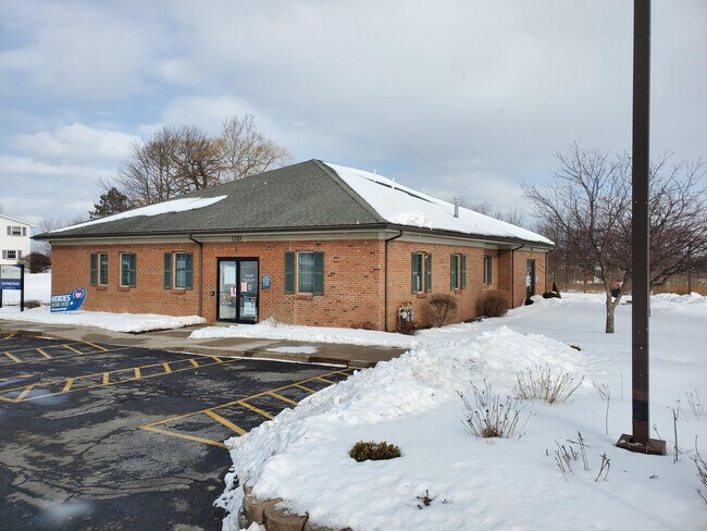
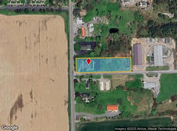
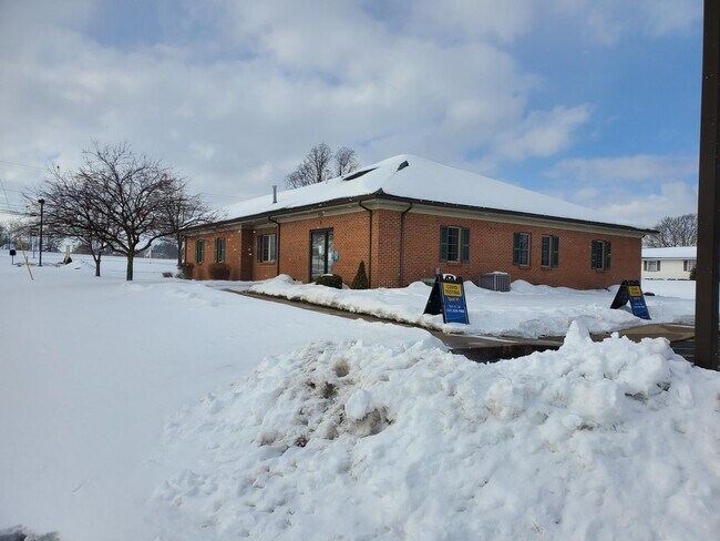
Property Record
7325 Community Dr, Lima, NY 14485
NEARBY LISTINGS FOR SALE OR LEASE
-
-
View all Lima listings for lease on LoopNet.com
Property Detail
7325 Community Dr
Rochester, NY
Livingston
243201-037-014-0001-035-213-0000
New York
Medicalclinic
35.213
2025
1.67 AC
2024
Livingston County
030600
Rochester
DEMOGRAPHICS near 7325 Community Dr
1 Mile
3 Mile
5 Mile
2024 Total Population
1,976
4,340
12,221
2029 Population
1,986
4,312
12,086
Pop Growth 2024-2029
+ 0.51%
(0.65%)
(1.10%)
Average Age
41
42
43
2024 Total Households
802
1,752
5,150
HH Growth 2024-2029
+ 0.50%
(0.74%)
(1.15%)
Median Household Inc
$65,696
$70,540
$74,401
Avg Household Size
2.40
2.40
2.30
2024 Avg HH Vehicles
2.00
2.00
2.00
Median Home Value
$159,078
$166,308
$182,019
Median Year Built
1980
1976
1975
Nearby Places
- Restaurants
- Banks
- Shops
- Fitness
- Groceries
PUBLIC TRANSPORTATION
AIRPORT
Frederick Douglass/Greater Rochester International
DRIVE
WALK
Distance
Frederick Douglass/Greater Rochester International
32 min
22.8 mi
Freight Ports
Albany, NY Port
DRIVE
WALK
Distance
Albany, NY Port
274 min
226.9 mi
SALE & LEASE HISTORY
LISTING DATE
SALE/LEASE

Jan 28, 2022
For Lease
Nearby Properties
Address
Land Use
TOTAL SIZE
Lot Size
Zoning
Address
Land Use
TOTAL SIZE
Lot Size
Zoning
0.25 AC
08 - GOVER
Address
Land Use
TOTAL SIZE
Lot Size
Zoning
1,762 SF
34.20 AC
04 - FARM
Address
Land Use
TOTAL SIZE
Lot Size
Zoning
9.86 AC
05 - COMME
Address
Land Use
TOTAL SIZE
Lot Size
Zoning
Address
Land Use
TOTAL SIZE
Lot Size
Zoning
Address
Land Use
TOTAL SIZE
Lot Size
Zoning
1,856 SF
21.90 AC
R
Address
Land Use
TOTAL SIZE
Lot Size
Zoning
783 SF
8.01 AC
08 - GOVER
Address
Land Use
TOTAL SIZE
Lot Size
Zoning
7.50 AC
S
Address
Land Use
TOTAL SIZE
Lot Size
Zoning
11,408 SF
4.80 AC
03 - MULTI
Address
Land Use
TOTAL SIZE
Lot Size
Zoning
23,360 SF
39.97 AC
04 - FARM
Address
Land Use
TOTAL SIZE
Lot Size
Zoning
Address
Land Use
TOTAL SIZE
Lot Size
Zoning
426 AC
04 - FARM
Address
Land Use
TOTAL SIZE
Lot Size
Zoning
28,720 SF
12.60 AC
06 - INDUS
Address
Land Use
TOTAL SIZE
Lot Size
Zoning
296.10 AC
04 - FARM
Address
Land Use
TOTAL SIZE
Lot Size
Zoning
576 SF
15.66 AC
A
Address
Land Use
TOTAL SIZE
Lot Size
Zoning
17,200 SF
3.20 AC
06 - INDUS
Address
Land Use
TOTAL SIZE
Lot Size
Zoning
226 AC
04 - FARM
Address
Land Use
TOTAL SIZE
Lot Size
Zoning
11,012 SF
2.20 AC
05 - COMME
Address
Land Use
TOTAL SIZE
Lot Size
Zoning
15,773 SF
1.23 AC
05 - COMME
Address
Land Use
TOTAL SIZE
Lot Size
Zoning
19.65 AC
06 - INDUS
Address
Land Use
TOTAL SIZE
Lot Size
Zoning
Address
Land Use
TOTAL SIZE
Lot Size
Zoning
1,755 SF
27.80 AC
03 - MULTI
Address
Land Use
TOTAL SIZE
Lot Size
Zoning
4,574 SF
5 AC
03 - MULTI
Address
Land Use
TOTAL SIZE
Lot Size
Zoning
3,600 SF
5.12 AC
05 - COMME
Address
Land Use
TOTAL SIZE
Lot Size
Zoning
251 AC
04 - FARM
Address
Land Use
TOTAL SIZE
Lot Size
Zoning
9,029 SF
5 AC
05 - COMME
Address
Land Use
TOTAL SIZE
Lot Size
Zoning
3 AC
06 - INDUS
Address
Land Use
TOTAL SIZE
Lot Size
Zoning
138.60 AC
04 - FARM
Address
Land Use
TOTAL SIZE
Lot Size
Zoning
7,632 SF
13.40 AC
05 - COMME
Address
Land Use
TOTAL SIZE
Lot Size
Zoning
15.81 AC
04 - FARM
The World's #1 Commercial Real Estate Marketplace
Connect with us
© 2025 CoStar Group
The information above has been obtained from sources believed reliable. While we do not doubt its accuracy we have not verified it and make no guarantee, warranty or representation about it. It is your responsibility to independently confirm its accuracy and completeness. Any projections, opinions, assumptions, or estimates used are for example only and do not represent the current or future performance of the property. The value of this transaction to you depends on tax and other factors which should be evaluated by your tax, financial, and legal advisors. You and your advisors should conduct a careful, independent investigation of the property to determine to your satisfaction the suitability of the property for your needs.