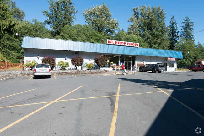
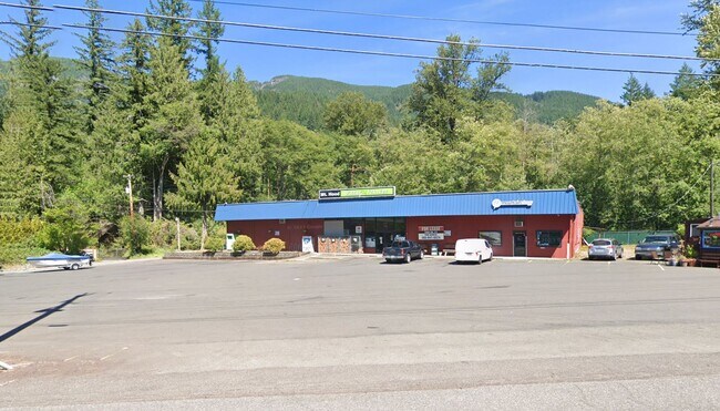
Property Record
73265 E Highway 26, Rhododendron, OR 97049


Property Detail
73265 E Highway 26
00982654
291 RHODODENDRON PT BLK B
Commercialbuilding
Clackamas
RTC
Oregon
B and X Area of moderate flood hazard, usually the area between the limits of the 100-year and 500-year floods.
0.94 AC
2025
SE Outlying
2025
Portland
024304
Portland-Vancouver-Hillsboro, OR-WA
NEARBY LISTINGS FOR SALE OR LEASE
-
-
View all Rhododendron listings for lease on LoopNet.com
DEMOGRAPHICS near 73265 E Highway 26
1 mile
3 mile
5 mile
2025 Total Population
441
4,249
6,765
2030 Population
502
4,648
7,361
Pop Growth 2025-2030
+ 13.83%
+ 9.39%
+ 8.81%
Average Age
46
48
48
2025 Total Households
203
1,932
3,037
HH Growth 2025-2030
+ 14.29%
+ 9.63%
+ 8.96%
Median Household Inc
$90,679
$89,538
$91,270
Avg Household Size
2.10
2.20
2.20
2025 Avg HH Vehicles
2.00
2.00
2.00
Median Home Value
$410,000
$402,273
$450,715
Median Year Built
1971
1982
1984
Nearby Places
Map Layers
Map Styles
 Street
 Aerial
Transit
 Traffic
 Biking
Places
Listings with unknown addresses are not visible on the map
- Restaurants
- Banks
- Shops
- Fitness
- Groceries
SALE & LEASE HISTORY
LISTING DATE
SALE/LEASE

Apr 01, 2024
For Lease
Nearby Properties
Address
Land Use
TOTAL SIZE
Lot Size
Zoning
Address
Land Use
TOTAL SIZE
Lot Size
Zoning
2 AC
MRR
Address
Land Use
TOTAL SIZE
Lot Size
Zoning
2.05 AC
MRR
Address
Land Use
TOTAL SIZE
Lot Size
Zoning
2.71 AC
MRR
Address
Land Use
TOTAL SIZE
Lot Size
Zoning
4.54 AC
RTC
Address
Land Use
TOTAL SIZE
Lot Size
Zoning
Address
Land Use
TOTAL SIZE
Lot Size
Zoning
8,030 SF
66.21 AC
OSM
Address
Land Use
TOTAL SIZE
Lot Size
Zoning
1.34 AC
RTC
Address
Land Use
TOTAL SIZE
Lot Size
Zoning
2 AC
RTC
Address
Land Use
TOTAL SIZE
Lot Size
Zoning
0.47 AC
RTC
Address
Land Use
TOTAL SIZE
Lot Size
Zoning
0.86 AC
RTC
Address
Land Use
TOTAL SIZE
Lot Size
Zoning
0.38 AC
MRR
Address
Land Use
TOTAL SIZE
Lot Size
Zoning
0.34 AC
MRR
Address
Land Use
TOTAL SIZE
Lot Size
Zoning
0.57 AC
MRR
Address
Land Use
TOTAL SIZE
Lot Size
Zoning
0.67 AC
MRR
Address
Land Use
TOTAL SIZE
Lot Size
Zoning
171.75 AC
TBR
Address
Land Use
TOTAL SIZE
Lot Size
Zoning
0.87 AC
RTC
Address
Land Use
TOTAL SIZE
Lot Size
Zoning
0.92 AC
RTC
Address
Land Use
TOTAL SIZE
Lot Size
Zoning
0.40 AC
RTC
Address
Land Use
TOTAL SIZE
Lot Size
Zoning
0.60 AC
RR
Address
Land Use
TOTAL SIZE
Lot Size
Zoning
0.77 AC
RC
Address
Land Use
TOTAL SIZE
Lot Size
Zoning
0.36 AC
MRR
Address
Land Use
TOTAL SIZE
Lot Size
Zoning
0.36 AC
RTC
Address
Land Use
TOTAL SIZE
Lot Size
Zoning
0.50 AC
RTC
Address
Land Use
TOTAL SIZE
Lot Size
Zoning
0.64 AC
RTC
Address
Land Use
TOTAL SIZE
Lot Size
Zoning
0.50 AC
RTC
Address
Land Use
TOTAL SIZE
Lot Size
Zoning
500 SF
0.78 AC
MRR
Address
Land Use
TOTAL SIZE
Lot Size
Zoning
174.65 AC
TBR
Address
Land Use
TOTAL SIZE
Lot Size
Zoning
2 AC
OSM
The World's #1 Commercial Real Estate Marketplace
Connect with us
© 2026 CoStar Group
The information above has been obtained from sources believed reliable. While we do not doubt its accuracy we have not verified it and make no guarantee, warranty or representation about it. It is your responsibility to independently confirm its accuracy and completeness. Any projections, opinions, assumptions, or estimates used are for example only and do not represent the current or future performance of the property. The value of this transaction to you depends on tax and other factors which should be evaluated by your tax, financial, and legal advisors. You and your advisors should conduct a careful, independent investigation of the property to determine to your satisfaction the suitability of the property for your needs.