Property Record
7329 Fannin St, Houston, TX 77030

NEARBY LISTINGS FOR SALE OR LEASE
Property Detail
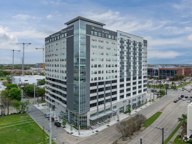
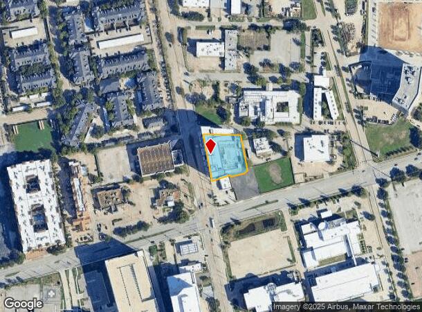
7329 Fannin St
1396960010003
Hyatt Place Reserve
Hotel
RES A1 BLK 1 HYATT PLACE RESERVE
X
Harris
48201C0860L
Texas
2024
0.86 AC
2025
Houston Medical Ctr/NRG Stadium
314001
Houston
186,637 SF
Houston-The Woodlands-Sugar Land, TX
DEMOGRAPHICS near 7329 Fannin St
1 Mile
3 Mile
5 Mile
2024 Total Population
21,659
166,015
449,725
2029 Population
22,513
172,036
465,810
Pop Growth 2024-2029
+ 3.94%
+ 3.63%
+ 3.58%
Average Age
35
38
38
2024 Total Households
12,012
77,487
204,737
HH Growth 2024-2029
+ 3.84%
+ 3.73%
+ 3.76%
Median Household Inc
$59,064
$68,751
$73,848
Avg Household Size
1.70
2.00
2.10
2024 Avg HH Vehicles
1.00
1.00
1.00
Median Home Value
$245,565
$495,931
$417,818
Median Year Built
1989
1991
1993
Nearby Places
Map Layers
Map Styles
 Street
 Aerial
- Restaurants
- Banks
- Shops
- Fitness
- Groceries
PUBLIC TRANSPORTATION
TRANSIT/SUBWAY
Smith Lands (METRORAIL RED LINE - Metropolitan Transit Authority of Harris County, Redline - Metropolitan Transit Authority of Harris County)
DRIVE
WALK
Distance
Smith Lands (METRORAIL RED LINE - Metropolitan Transit Authority of Harris County, Redline - Metropolitan Transit Authority of Harris County)
1 min
8 min
0.5 mi
Tmc Transit Center (METRORAIL RED LINE - Metropolitan Transit Authority of Harris County, Redline - Metropolitan Transit Authority of Harris County)
DRIVE
WALK
Distance
Tmc Transit Center (METRORAIL RED LINE - Metropolitan Transit Authority of Harris County, Redline - Metropolitan Transit Authority of Harris County)
2 min
10 min
0.5 mi
Reliant Park (METRORAIL RED LINE - Metropolitan Transit Authority of Harris County, Redline - Metropolitan Transit Authority of Harris County)
DRIVE
WALK
Distance
Reliant Park (METRORAIL RED LINE - Metropolitan Transit Authority of Harris County, Redline - Metropolitan Transit Authority of Harris County)
1 min
15 min
0.8 mi
Dryden/Tmc Stn Sb (METRORAIL RED LINE - Metropolitan Transit Authority of Harris County)
DRIVE
WALK
Distance
Dryden/Tmc Stn Sb (METRORAIL RED LINE - Metropolitan Transit Authority of Harris County)
1 min
17 min
0.9 mi
Dryden/Tmc (Redline - Harris County Metropolitan Transit Authority METRO Rail (METRORail))
DRIVE
WALK
Distance
Dryden/Tmc (Redline - Harris County Metropolitan Transit Authority METRO Rail (METRORail))
2 min
18 min
1.0 mi
COMMUTER RAIL
Houston (Sunset Limited - Amtrak)
DRIVE
WALK
Distance
Houston (Sunset Limited - Amtrak)
13 min
6.7 mi
AIRPORT
William P Hobby
DRIVE
WALK
Distance
William P Hobby
24 min
13.0 mi
George Bush Intcntl/Houston
DRIVE
WALK
Distance
George Bush Intcntl/Houston
33 min
24.0 mi
Freight Ports
Port of Houston
DRIVE
WALK
Distance
Port of Houston
21 min
13.2 mi
Nearby Properties
Address
Land Use
TOTAL SIZE
Lot Size
Zoning
Address
Land Use
TOTAL SIZE
Lot Size
Zoning
519,409 SF
1.52 AC
Address
Land Use
TOTAL SIZE
Lot Size
Zoning
1,252,274 SF
2.02 AC
Address
Land Use
TOTAL SIZE
Lot Size
Zoning
704,249 SF
2.34 AC
Address
Land Use
TOTAL SIZE
Lot Size
Zoning
1,044,305 SF
3.16 AC
Address
Land Use
TOTAL SIZE
Lot Size
Zoning
1,359,194 SF
Address
Land Use
TOTAL SIZE
Lot Size
Zoning
402,467 SF
28.30 AC
Address
Land Use
TOTAL SIZE
Lot Size
Zoning
1,009,859 SF
28.73 AC
Address
Land Use
TOTAL SIZE
Lot Size
Zoning
701,043 SF
4.69 AC
Address
Land Use
TOTAL SIZE
Lot Size
Zoning
958,147 SF
16.60 AC
Address
Land Use
TOTAL SIZE
Lot Size
Zoning
507,499 SF
7.66 AC
Address
Land Use
TOTAL SIZE
Lot Size
Zoning
310,967 SF
1.38 AC
Address
Land Use
TOTAL SIZE
Lot Size
Zoning
444,589 SF
11 AC
Address
Land Use
TOTAL SIZE
Lot Size
Zoning
577,327 SF
28.80 AC
Address
Land Use
TOTAL SIZE
Lot Size
Zoning
828,746 SF
7.76 AC
Address
Land Use
TOTAL SIZE
Lot Size
Zoning
607,893 SF
3.69 AC
Address
Land Use
TOTAL SIZE
Lot Size
Zoning
396,888 SF
2.02 AC
Address
Land Use
TOTAL SIZE
Lot Size
Zoning
1,279,489 SF
2.83 AC
Address
Land Use
TOTAL SIZE
Lot Size
Zoning
261,388 SF
1.56 AC
Address
Land Use
TOTAL SIZE
Lot Size
Zoning
171,997 SF
1.15 AC
Address
Land Use
TOTAL SIZE
Lot Size
Zoning
486,076 SF
3.79 AC
Address
Land Use
TOTAL SIZE
Lot Size
Zoning
565,246 SF
1.14 AC
Address
Land Use
TOTAL SIZE
Lot Size
Zoning
290,097 SF
2.61 AC
Address
Land Use
TOTAL SIZE
Lot Size
Zoning
552,795 SF
4.29 AC
Address
Land Use
TOTAL SIZE
Lot Size
Zoning
320,710 SF
1.19 AC
Address
Land Use
TOTAL SIZE
Lot Size
Zoning
517,548 SF
1.60 AC
Address
Land Use
TOTAL SIZE
Lot Size
Zoning
519,237 SF
1.73 AC
Address
Land Use
TOTAL SIZE
Lot Size
Zoning
316,101 SF
2.12 AC
Address
Land Use
TOTAL SIZE
Lot Size
Zoning
527,457 SF
6.21 AC
Address
Land Use
TOTAL SIZE
Lot Size
Zoning
590,425 SF
8.87 AC
Address
Land Use
TOTAL SIZE
Lot Size
Zoning
499,411 SF
5.73 AC
The World's #1 Commercial Real Estate Marketplace
Connect with us
© 2026 CoStar Group
The information above has been obtained from sources believed reliable. While we do not doubt its accuracy we have not verified it and make no guarantee, warranty or representation about it. It is your responsibility to independently confirm its accuracy and completeness. Any projections, opinions, assumptions, or estimates used are for example only and do not represent the current or future performance of the property. The value of this transaction to you depends on tax and other factors which should be evaluated by your tax, financial, and legal advisors. You and your advisors should conduct a careful, independent investigation of the property to determine to your satisfaction the suitability of the property for your needs.