Property Record
733 7Th Ave, Kirkland, WA 98033
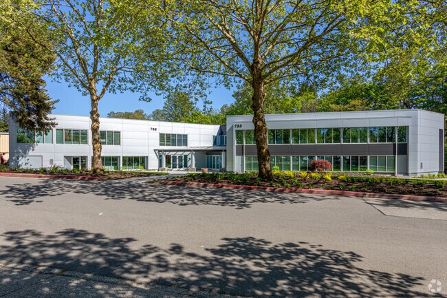
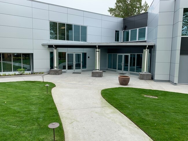
This Property Is For Sale
NEARBY LISTINGS FOR SALE OR LEASE
Property Detail
733 7Th Ave
Seattle-Tacoma-Bellevue, WA
Kirkland Supl Plat
388690-1360
KIRKLAND SUPL PLAT TGW VAC POR 6TH AVE (NE 86TH ST/CASCADE AVE) PER KIRKLAND ORD #3542 REC #9606260988
Officebuilding
King
X
Washington
53033C0365G
8-15
2025
1.01 AC
2024
Kirkland
022502
Seattle/Puget Sound
26,658 SF
DEMOGRAPHICS near 733 7Th Ave
1 Mile
3 Mile
5 Mile
2024 Total Population
18,519
93,690
300,092
2029 Population
18,797
95,142
303,927
Pop Growth 2024-2029
+ 1.50%
+ 1.55%
+ 1.28%
Average Age
41
39
39
2024 Total Households
8,428
39,236
124,711
HH Growth 2024-2029
+ 1.47%
+ 1.52%
+ 1.35%
Median Household Inc
$153,727
$139,925
$148,983
Avg Household Size
2.20
2.30
2.30
2024 Avg HH Vehicles
2.00
2.00
2.00
Median Home Value
$1,078,981
$1,017,511
$1,012,256
Median Year Built
1990
1985
1986
Nearby Places
Map Layers
Map Styles
 Street
 Aerial
- Restaurants
- Banks
- Shops
- Fitness
- Groceries
PUBLIC TRANSPORTATION
AIRPORT
Seattle Paine Field International
DRIVE
WALK
Distance
Seattle Paine Field International
29 min
19.4 mi
Seattle-Tacoma International
DRIVE
WALK
Distance
Seattle-Tacoma International
33 min
21.9 mi
Nearby Properties
Address
Land Use
TOTAL SIZE
Lot Size
Zoning
Address
Land Use
TOTAL SIZE
Lot Size
Zoning
570,472 SF
17.39 AC
TL 3A
Address
Land Use
TOTAL SIZE
Lot Size
Zoning
105,056 SF
15.92 AC
PLA 15A
Address
Land Use
TOTAL SIZE
Lot Size
Zoning
407,216 SF
45.12 AC
PLA 9
Address
Land Use
TOTAL SIZE
Lot Size
Zoning
747,347 SF
8.91 AC
BP
Address
Land Use
TOTAL SIZE
Lot Size
Zoning
295,212 SF
10.57 AC
PLA 3B
Address
Land Use
TOTAL SIZE
Lot Size
Zoning
11,970 SF
4.81 AC
TL 6A
Address
Land Use
TOTAL SIZE
Lot Size
Zoning
572,539 SF
2.50 AC
CBD 5A
Address
Land Use
TOTAL SIZE
Lot Size
Zoning
279,488 SF
20.82 AC
NMF
Address
Land Use
TOTAL SIZE
Lot Size
Zoning
240 SF
471.44 AC
R1
Address
Land Use
TOTAL SIZE
Lot Size
Zoning
141,158 SF
15.81 AC
OBAT
Address
Land Use
TOTAL SIZE
Lot Size
Zoning
98,914 SF
10.38 AC
SMT
Address
Land Use
TOTAL SIZE
Lot Size
Zoning
212,688 SF
1.46 AC
JBD 1
Address
Land Use
TOTAL SIZE
Lot Size
Zoning
177,772 SF
2.03 AC
JBD 1
Address
Land Use
TOTAL SIZE
Lot Size
Zoning
249,064 SF
16.37 AC
R-20
Address
Land Use
TOTAL SIZE
Lot Size
Zoning
231,840 SF
22.82 AC
RMA 2.4
Address
Land Use
TOTAL SIZE
Lot Size
Zoning
7,381 SF
1.30 AC
CBD 1B
Address
Land Use
TOTAL SIZE
Lot Size
Zoning
159,152 SF
2.83 AC
JBD 1
Address
Land Use
TOTAL SIZE
Lot Size
Zoning
272,800 SF
19.26 AC
RM 2.4
Address
Land Use
TOTAL SIZE
Lot Size
Zoning
25.95 AC
OBAT
Address
Land Use
TOTAL SIZE
Lot Size
Zoning
73,729 SF
42.57 AC
RSX 7.2
Address
Land Use
TOTAL SIZE
Lot Size
Zoning
444,618 SF
4.78 AC
PLA 6G
Address
Land Use
TOTAL SIZE
Lot Size
Zoning
100,736 SF
0.96 AC
CBD 1B
Address
Land Use
TOTAL SIZE
Lot Size
Zoning
65,622 SF
6.20 AC
LIT
Address
Land Use
TOTAL SIZE
Lot Size
Zoning
187,860 SF
12.68 AC
TL 11
Address
Land Use
TOTAL SIZE
Lot Size
Zoning
43,016 SF
10.33 AC
TL 2
Address
Land Use
TOTAL SIZE
Lot Size
Zoning
1.62 AC
NWDD
Address
Land Use
TOTAL SIZE
Lot Size
Zoning
134,918 SF
1.55 AC
CBD 6
Address
Land Use
TOTAL SIZE
Lot Size
Zoning
220,523 SF
11.63 AC
BP
Address
Land Use
TOTAL SIZE
Lot Size
Zoning
226,050 SF
33.65 AC
CVU
The World's #1 Commercial Real Estate Marketplace
Connect with us
© 2025 CoStar Group
The information above has been obtained from sources believed reliable. While we do not doubt its accuracy we have not verified it and make no guarantee, warranty or representation about it. It is your responsibility to independently confirm its accuracy and completeness. Any projections, opinions, assumptions, or estimates used are for example only and do not represent the current or future performance of the property. The value of this transaction to you depends on tax and other factors which should be evaluated by your tax, financial, and legal advisors. You and your advisors should conduct a careful, independent investigation of the property to determine to your satisfaction the suitability of the property for your needs.