Property Record
733 Davis St, Scranton, PA 18505

Save to a Folder
{{folder.Name}}
{{folder.ListingIds.length}} Properties
{{folder.ListingIds.length}} Property
Create a New Folder
Property Detail
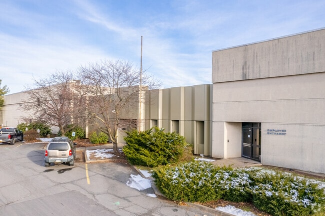
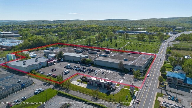
733 Davis St
Scranton--Wilkes-Barre, PA
9.07A W-24 B-028
1770502000701
Lackawanna
Warehouse
Pennsylvania
B and X Area of moderate flood hazard, usually the area between the limits of the 100-year and 500-year floods.
9.07 AC
2026
I-81 Corridor
2026
Philadelphia
103100
NEARBY LISTINGS FOR SALE OR LEASE
DEMOGRAPHICS near 733 Davis St
1 mile
3 mile
5 mile
2025 Total Population
5,212
61,673
115,689
2030 Population
5,162
62,002
115,958
Pop Growth 2025-2030
(0.96%)
+ 0.53%
+ 0.23%
Average Age
42
41
41
2025 Total Households
2,174
25,048
47,360
HH Growth 2025-2030
(0.92%)
+ 0.65%
+ 0.26%
Median Household Inc
$50,185
$44,913
$49,395
Avg Household Size
2.30
2.20
2.20
2025 Avg HH Vehicles
2.00
1.00
2.00
Median Home Value
$172,078
$159,746
$164,896
Median Year Built
1962
1949
1948
Nearby Places
Map Layers
Map Styles
 Street
 Aerial
Layers
 Traffic
 Biking
Places
Listings with unknown addresses are not visible on the map
- Restaurants
- Banks
- Shops
- Fitness
- Groceries
PUBLIC TRANSPORTATION
AIRPORT
Wilkes-Barre/Scranton International
Drive
Walk
Distance
Wilkes-Barre/Scranton International
10 min
5.4 mi
Freight Ports
Maher Terminal
Drive
Walk
Distance
Maher Terminal
146 min
117.4 mi
SALE & LEASE HISTORY
LISTING DATE
SALE/LEASE

Sep 25, 2016
For Lease
May 15, 2024
For Lease
Feb 18, 2021
For Lease
Apr 27, 2017
For Sale
Nearby Properties
Address
Land Use
TOTAL SIZE
Lot Size
Zoning
Address
Land Use
TOTAL SIZE
Lot Size
Zoning
2.40 AC
Address
Land Use
TOTAL SIZE
Lot Size
Zoning
3.02 AC
Address
Land Use
TOTAL SIZE
Lot Size
Zoning
34.57 AC
Address
Land Use
TOTAL SIZE
Lot Size
Zoning
36.41 AC
Address
Land Use
TOTAL SIZE
Lot Size
Zoning
0.99 AC
Address
Land Use
TOTAL SIZE
Lot Size
Zoning
15.07 AC
Address
Land Use
TOTAL SIZE
Lot Size
Zoning
Address
Land Use
TOTAL SIZE
Lot Size
Zoning
1.52 AC
Address
Land Use
TOTAL SIZE
Lot Size
Zoning
Address
Land Use
TOTAL SIZE
Lot Size
Zoning
Address
Land Use
TOTAL SIZE
Lot Size
Zoning
Address
Land Use
TOTAL SIZE
Lot Size
Zoning
14.63 AC
Address
Land Use
TOTAL SIZE
Lot Size
Zoning
15.50 AC
Address
Land Use
TOTAL SIZE
Lot Size
Zoning
Address
Land Use
TOTAL SIZE
Lot Size
Zoning
41.19 AC
Address
Land Use
TOTAL SIZE
Lot Size
Zoning
3.11 AC
Address
Land Use
TOTAL SIZE
Lot Size
Zoning
0.15 AC
Address
Land Use
TOTAL SIZE
Lot Size
Zoning
3.58 AC
Address
Land Use
TOTAL SIZE
Lot Size
Zoning
12.26 AC
Address
Land Use
TOTAL SIZE
Lot Size
Zoning
Address
Land Use
TOTAL SIZE
Lot Size
Zoning
Address
Land Use
TOTAL SIZE
Lot Size
Zoning
0.37 AC
Address
Land Use
TOTAL SIZE
Lot Size
Zoning
0.16 AC
Address
Land Use
TOTAL SIZE
Lot Size
Zoning
0.06 AC
Address
Land Use
TOTAL SIZE
Lot Size
Zoning
26.80 AC
Address
Land Use
TOTAL SIZE
Lot Size
Zoning
1.74 AC
Address
Land Use
TOTAL SIZE
Lot Size
Zoning
27.12 AC
Address
Land Use
TOTAL SIZE
Lot Size
Zoning
0.87 AC
Address
Land Use
TOTAL SIZE
Lot Size
Zoning
9.20 AC
Address
Land Use
TOTAL SIZE
Lot Size
Zoning
51.10 AC
The World's #1 Commercial Real Estate Marketplace
Connect with us
© 2026 CoStar Group
The information above has been obtained from sources believed reliable. While we do not doubt its accuracy we have not verified it and make no guarantee, warranty or representation about it. It is your responsibility to independently confirm its accuracy and completeness. Any projections, opinions, assumptions, or estimates used are for example only and do not represent the current or future performance of the property. The value of this transaction to you depends on tax and other factors which should be evaluated by your tax, financial, and legal advisors. You and your advisors should conduct a careful, independent investigation of the property to determine to your satisfaction the suitability of the property for your needs.