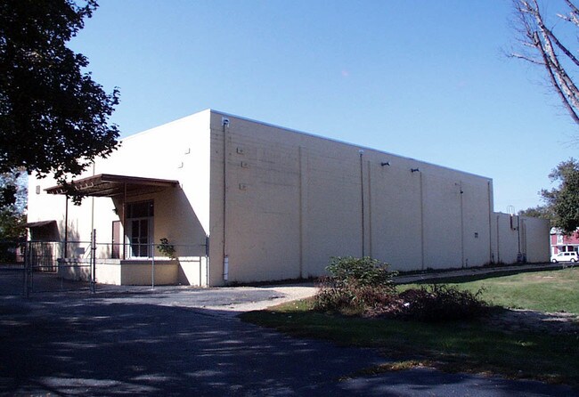
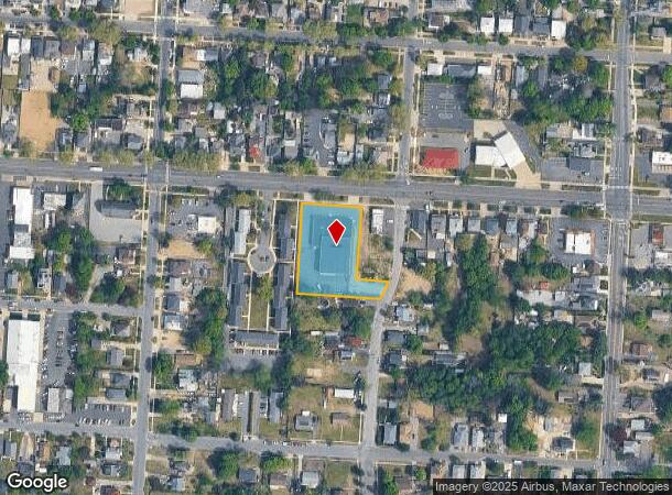
Property Record
733 E Chestnut Ave, Vineland, NJ 08360
NEARBY LISTINGS FOR SALE OR LEASE
Property Detail
733 E Chestnut Ave
Vineland-Bridgeton, NJ
FACILITY NAME: SALVATION ARMY
14-04903-0000-00003
Cumberland
Religious
New Jersey
X
3
34011C0185E
1.06 AC
0
Vineland/Bridgeton
2025
Philadelphia
040602
DEMOGRAPHICS near 733 E Chestnut Ave
1 Mile
3 Mile
5 Mile
2024 Total Population
15,046
47,031
66,732
2029 Population
14,731
46,281
65,876
Pop Growth 2024-2029
(2.09%)
(1.59%)
(1.28%)
Average Age
37
39
40
2024 Total Households
5,382
16,981
24,580
HH Growth 2024-2029
(2.16%)
(1.67%)
(1.38%)
Median Household Inc
$48,354
$58,029
$61,993
Avg Household Size
2.70
2.70
2.60
2024 Avg HH Vehicles
2.00
2.00
2.00
Median Home Value
$160,034
$192,326
$206,234
Median Year Built
1961
1967
1970
Nearby Places
Map Layers
Map Styles
 Street
 Aerial
- Restaurants
- Banks
- Shops
- Fitness
- Groceries
PUBLIC TRANSPORTATION
AIRPORT
Atlantic City International
DRIVE
WALK
Distance
Atlantic City International
53 min
27.4 mi
Philadelphia International
DRIVE
WALK
Distance
Philadelphia International
54 min
46.2 mi
Nearby Properties
Address
Land Use
TOTAL SIZE
Lot Size
Zoning
Address
Land Use
TOTAL SIZE
Lot Size
Zoning
156.67 AC
R4
Address
Land Use
TOTAL SIZE
Lot Size
Zoning
69.16 AC
R5
Address
Land Use
TOTAL SIZE
Lot Size
Zoning
28.47 AC
RI
Address
Land Use
TOTAL SIZE
Lot Size
Zoning
276.61 AC
I4
Address
Land Use
TOTAL SIZE
Lot Size
Zoning
5 AC
R2
Address
Land Use
TOTAL SIZE
Lot Size
Zoning
Address
Land Use
TOTAL SIZE
Lot Size
Zoning
29.39 AC
B3
Address
Land Use
TOTAL SIZE
Lot Size
Zoning
26.96 AC
Address
Land Use
TOTAL SIZE
Lot Size
Zoning
8.93 AC
R1
Address
Land Use
TOTAL SIZE
Lot Size
Zoning
26.39 AC
R3
Address
Land Use
TOTAL SIZE
Lot Size
Zoning
25.52 AC
R5
Address
Land Use
TOTAL SIZE
Lot Size
Zoning
40 AC
R5
Address
Land Use
TOTAL SIZE
Lot Size
Zoning
Address
Land Use
TOTAL SIZE
Lot Size
Zoning
17.01 AC
R3
Address
Land Use
TOTAL SIZE
Lot Size
Zoning
33.79 AC
I3
Address
Land Use
TOTAL SIZE
Lot Size
Zoning
11.91 AC
R5
Address
Land Use
TOTAL SIZE
Lot Size
Zoning
16.09 AC
I2
Address
Land Use
TOTAL SIZE
Lot Size
Zoning
11.15 AC
Address
Land Use
TOTAL SIZE
Lot Size
Zoning
44.55 AC
R3
Address
Land Use
TOTAL SIZE
Lot Size
Zoning
18.45 AC
R4
Address
Land Use
TOTAL SIZE
Lot Size
Zoning
10.23 AC
I2
Address
Land Use
TOTAL SIZE
Lot Size
Zoning
20.61 AC
R2
Address
Land Use
TOTAL SIZE
Lot Size
Zoning
7.24 AC
R4
Address
Land Use
TOTAL SIZE
Lot Size
Zoning
7.20 AC
R4
Address
Land Use
TOTAL SIZE
Lot Size
Zoning
24,820 SF
15 AC
R3
Address
Land Use
TOTAL SIZE
Lot Size
Zoning
19.82 AC
R5
Address
Land Use
TOTAL SIZE
Lot Size
Zoning
Address
Land Use
TOTAL SIZE
Lot Size
Zoning
7.71 AC
B3
Address
Land Use
TOTAL SIZE
Lot Size
Zoning
18.25 AC
R3
Address
Land Use
TOTAL SIZE
Lot Size
Zoning
21.80 AC
R4
The World's #1 Commercial Real Estate Marketplace
Connect with us
© 2025 CoStar Group
The information above has been obtained from sources believed reliable. While we do not doubt its accuracy we have not verified it and make no guarantee, warranty or representation about it. It is your responsibility to independently confirm its accuracy and completeness. Any projections, opinions, assumptions, or estimates used are for example only and do not represent the current or future performance of the property. The value of this transaction to you depends on tax and other factors which should be evaluated by your tax, financial, and legal advisors. You and your advisors should conduct a careful, independent investigation of the property to determine to your satisfaction the suitability of the property for your needs.