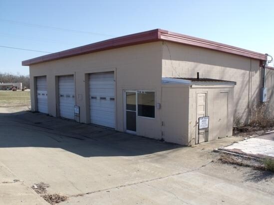
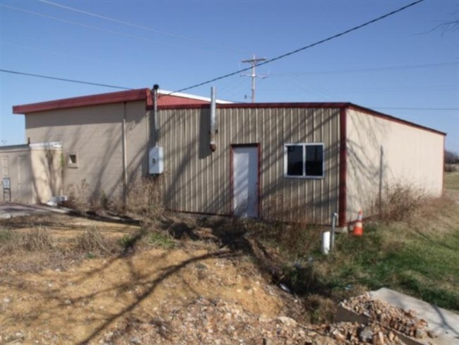
Property Record
733 E Main St, Gassville, AR 72635

Property Detail
733 E Main St
005-02806-000
PART OF THE EAST HALF (E1/2) OF THE SOUTHEAST QUARTER (SE1/4) OF SECTION 28, TOWNSHIP 19 NORTH, RANGE 14 WEST, BAXTER COUNTY, ARKANSAS, DESCRIBED AS FOLLOWS: BEGIN AT THE SOUTHEAST CORNER OF SAID SECTION 28 AND RUN THENCE NORTH 01? 31' 39" EAST 1441.
Conveniencestore
Baxter
B and X Area of moderate flood hazard, usually the area between the limits of the 100-year and 500-year floods.
Arkansas
2025
1.18 AC
2025
Arkansas North Area
950900
Other Market Areas
4,792 SF
Mountain Home, AR
NEARBY LISTINGS FOR SALE OR LEASE
-
-
View all Gassville listings for sale on LoopNet.com
DEMOGRAPHICS near 733 E Main St
1 mile
3 mile
5 mile
2025 Total Population
1,604
3,867
8,428
2030 Population
1,628
3,936
8,653
Pop Growth 2025-2030
+ 1.50%
+ 1.78%
+ 2.67%
Average Age
42
43
45
2025 Total Households
642
1,597
3,590
HH Growth 2025-2030
+ 1.56%
+ 1.82%
+ 2.73%
Median Household Inc
$49,045
$48,102
$47,307
Avg Household Size
2.40
2.40
2.30
2025 Avg HH Vehicles
2.00
2.00
2.00
Median Home Value
$155,133
$163,412
$171,261
Median Year Built
1983
1981
1984
Nearby Places
Map Layers
Map Styles
 Street
 Aerial
Layers
 Traffic
 Biking
Places
Listings with unknown addresses are not visible on the map
- Restaurants
- Banks
- Shops
- Fitness
- Groceries
SALE & LEASE HISTORY
LISTING DATE
SALE/LEASE

Sep 24, 2016
For Sale
Nearby Properties
Address
Land Use
TOTAL SIZE
Lot Size
Zoning
Address
Land Use
TOTAL SIZE
Lot Size
Zoning
9,800 SF
11.89 AC
Address
Land Use
TOTAL SIZE
Lot Size
Zoning
1,874 SF
5 AC
Address
Land Use
TOTAL SIZE
Lot Size
Zoning
27,943 SF
4 AC
Address
Land Use
TOTAL SIZE
Lot Size
Zoning
49,984 SF
8.15 AC
Address
Land Use
TOTAL SIZE
Lot Size
Zoning
35,800 SF
8.06 AC
Address
Land Use
TOTAL SIZE
Lot Size
Zoning
2,700 SF
4.69 AC
Address
Land Use
TOTAL SIZE
Lot Size
Zoning
2,879 SF
1.50 AC
Address
Land Use
TOTAL SIZE
Lot Size
Zoning
4,514 SF
2.74 AC
Address
Land Use
TOTAL SIZE
Lot Size
Zoning
3,216 SF
2.47 AC
Address
Land Use
TOTAL SIZE
Lot Size
Zoning
6,000 SF
2.71 AC
Address
Land Use
TOTAL SIZE
Lot Size
Zoning
3,807 SF
1.20 AC
Address
Land Use
TOTAL SIZE
Lot Size
Zoning
1,160 SF
1.30 AC
Address
Land Use
TOTAL SIZE
Lot Size
Zoning
6,470 SF
1.18 AC
Address
Land Use
TOTAL SIZE
Lot Size
Zoning
12,690 SF
1.39 AC
Address
Land Use
TOTAL SIZE
Lot Size
Zoning
3,405 SF
1.05 AC
Address
Land Use
TOTAL SIZE
Lot Size
Zoning
11,580 SF
4.80 AC
Address
Land Use
TOTAL SIZE
Lot Size
Zoning
9,864 SF
0.70 AC
Address
Land Use
TOTAL SIZE
Lot Size
Zoning
11,500 SF
1.30 AC
Address
Land Use
TOTAL SIZE
Lot Size
Zoning
12,600 SF
3.04 AC
Address
Land Use
TOTAL SIZE
Lot Size
Zoning
10,715 SF
Address
Land Use
TOTAL SIZE
Lot Size
Zoning
2,190 SF
1.26 AC
Address
Land Use
TOTAL SIZE
Lot Size
Zoning
4,498 SF
1.87 AC
Address
Land Use
TOTAL SIZE
Lot Size
Zoning
1,951 SF
0.95 AC
Address
Land Use
TOTAL SIZE
Lot Size
Zoning
4,399 SF
8.26 AC
Address
Land Use
TOTAL SIZE
Lot Size
Zoning
18,180 SF
21.21 AC
Address
Land Use
TOTAL SIZE
Lot Size
Zoning
21,000 SF
5.13 AC
Address
Land Use
TOTAL SIZE
Lot Size
Zoning
3,020 SF
8.20 AC
Address
Land Use
TOTAL SIZE
Lot Size
Zoning
4,800 SF
4 AC
Address
Land Use
TOTAL SIZE
Lot Size
Zoning
3,016 SF
1.85 AC
The World's #1 Commercial Real Estate Marketplace
Connect with us
© 2026 CoStar Group
The information above has been obtained from sources believed reliable. While we do not doubt its accuracy we have not verified it and make no guarantee, warranty or representation about it. It is your responsibility to independently confirm its accuracy and completeness. Any projections, opinions, assumptions, or estimates used are for example only and do not represent the current or future performance of the property. The value of this transaction to you depends on tax and other factors which should be evaluated by your tax, financial, and legal advisors. You and your advisors should conduct a careful, independent investigation of the property to determine to your satisfaction the suitability of the property for your needs.