Property Record
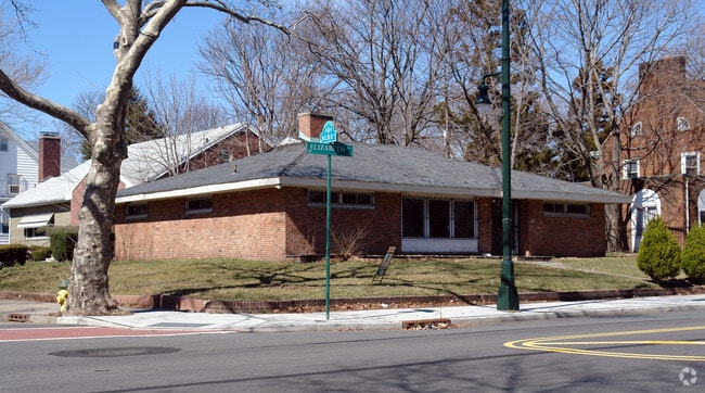
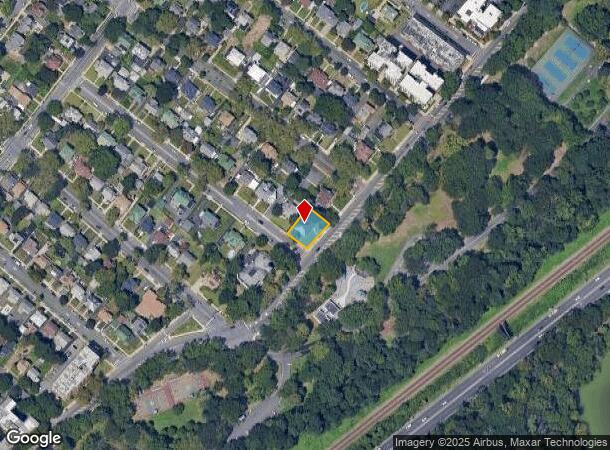
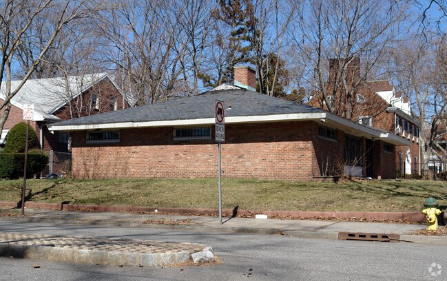
733 Elizabeth Ave, Newark, NJ 07112
NEARBY LISTINGS FOR SALE OR LEASE
Property Detail
733 Elizabeth Ave
Newark, NJ-PA
Weequahic Park
14-03681-0000-00005
100.2X79 AVG.
Commercialnec
Essex
X
New Jersey
34013C0154F
5
2023
0.18 AC
2025
Newark
004700
Northern New Jersey
2,200 SF
DEMOGRAPHICS near 733 Elizabeth Ave
1 Mile
3 Mile
5 Mile
2024 Total Population
34,967
307,738
741,470
2029 Population
33,784
298,534
720,823
Pop Growth 2024-2029
(3.38%)
(2.99%)
(2.78%)
Average Age
38
37
38
2024 Total Households
12,688
110,403
263,788
HH Growth 2024-2029
(3.52%)
(3.08%)
(2.83%)
Median Household Inc
$45,259
$50,489
$57,588
Avg Household Size
2.60
2.70
2.70
2024 Avg HH Vehicles
1.00
1.00
1.00
Median Home Value
$297,406
$332,084
$364,292
Median Year Built
1948
1958
1958
Nearby Places
Map Layers
Map Styles
 Street
 Aerial
- Restaurants
- Banks
- Shops
- Fitness
- Groceries
PUBLIC TRANSPORTATION
COMMUTER RAIL
Newark International Airport (AirTrain Newark - Port Authority of New York and New Jersey Airtrain (Airtrain))
DRIVE
WALK
Distance
Newark International Airport (AirTrain Newark - Port Authority of New York and New Jersey Airtrain (Airtrain))
6 min
2.0 mi
North Elizabeth (North Jersey Coast Line - NJ Transit Commuter Rail (NJ Transit), Northeast Corridor Line - NJ Transit Commuter Rail (NJ Transit))
DRIVE
WALK
Distance
North Elizabeth (North Jersey Coast Line - NJ Transit Commuter Rail (NJ Transit), Northeast Corridor Line - NJ Transit Commuter Rail (NJ Transit))
5 min
2.2 mi
AIRPORT
Newark Liberty International
DRIVE
WALK
Distance
Newark Liberty International
10 min
5.2 mi
LaGuardia
DRIVE
WALK
Distance
LaGuardia
45 min
22.6 mi
John F Kennedy International
DRIVE
WALK
Distance
John F Kennedy International
56 min
30.9 mi
Freight Ports
Maher Terminal
DRIVE
WALK
Distance
Maher Terminal
14 min
5.8 mi
Nearby Properties
Address
Land Use
TOTAL SIZE
Lot Size
Zoning
Address
Land Use
TOTAL SIZE
Lot Size
Zoning
Address
Land Use
TOTAL SIZE
Lot Size
Zoning
Address
Land Use
TOTAL SIZE
Lot Size
Zoning
Address
Land Use
TOTAL SIZE
Lot Size
Zoning
961.13 AC
Address
Land Use
TOTAL SIZE
Lot Size
Zoning
789.45 AC
Address
Land Use
TOTAL SIZE
Lot Size
Zoning
Address
Land Use
TOTAL SIZE
Lot Size
Zoning
11.36 AC
Address
Land Use
TOTAL SIZE
Lot Size
Zoning
0.61 AC
Address
Land Use
TOTAL SIZE
Lot Size
Zoning
Address
Land Use
TOTAL SIZE
Lot Size
Zoning
31.86 AC
Address
Land Use
TOTAL SIZE
Lot Size
Zoning
Address
Land Use
TOTAL SIZE
Lot Size
Zoning
877 SF
7.25 AC
Address
Land Use
TOTAL SIZE
Lot Size
Zoning
1,136 SF
6.51 AC
Address
Land Use
TOTAL SIZE
Lot Size
Zoning
683 SF
9.59 AC
Address
Land Use
TOTAL SIZE
Lot Size
Zoning
Address
Land Use
TOTAL SIZE
Lot Size
Zoning
19.03 AC
Address
Land Use
TOTAL SIZE
Lot Size
Zoning
5.89 AC
Address
Land Use
TOTAL SIZE
Lot Size
Zoning
Address
Land Use
TOTAL SIZE
Lot Size
Zoning
32.27 AC
CCRC
Address
Land Use
TOTAL SIZE
Lot Size
Zoning
Address
Land Use
TOTAL SIZE
Lot Size
Zoning
9.77 AC
Address
Land Use
TOTAL SIZE
Lot Size
Zoning
1.64 AC
Address
Land Use
TOTAL SIZE
Lot Size
Zoning
20,000 SF
30.36 AC
Address
Land Use
TOTAL SIZE
Lot Size
Zoning
4.82 AC
Address
Land Use
TOTAL SIZE
Lot Size
Zoning
1,264 SF
3.20 AC
Address
Land Use
TOTAL SIZE
Lot Size
Zoning
1.89 AC
Address
Land Use
TOTAL SIZE
Lot Size
Zoning
0.06 AC
Address
Land Use
TOTAL SIZE
Lot Size
Zoning
0.09 AC
Address
Land Use
TOTAL SIZE
Lot Size
Zoning
5,400,000 SF
35.22 AC
Address
Land Use
TOTAL SIZE
Lot Size
Zoning
The World's #1 Commercial Real Estate Marketplace
Connect with us
© 2025 CoStar Group
The information above has been obtained from sources believed reliable. While we do not doubt its accuracy we have not verified it and make no guarantee, warranty or representation about it. It is your responsibility to independently confirm its accuracy and completeness. Any projections, opinions, assumptions, or estimates used are for example only and do not represent the current or future performance of the property. The value of this transaction to you depends on tax and other factors which should be evaluated by your tax, financial, and legal advisors. You and your advisors should conduct a careful, independent investigation of the property to determine to your satisfaction the suitability of the property for your needs.