Property Record
733 Mcneely Rd, Clarkedale, AR 72325
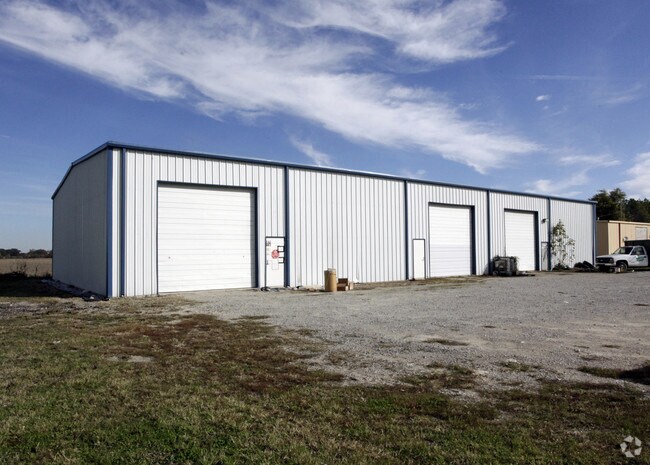


Property Detail
733 Mcneely Rd
Memphis, TN-MS-AR
PLAT BK 5 PG 313
204-375000-200
CRITTENDEN
Warehouse
Arkansas
A Areas with a 1% annual chance of flooding and a 26% chance of flooding over the life of a 30-year mortgage.
3
2025
1.66 AC
2025
Crittenden County
030807
Memphis
7,500 SF
NEARBY LISTINGS FOR SALE OR LEASE
DEMOGRAPHICS near 733 Mcneely Rd
1 mile
3 mile
5 mile
2025 Total Population
910
3,060
13,302
2030 Population
880
2,994
12,859
Pop Growth 2025-2030
(3.30%)
(2.16%)
(3.33%)
Average Age
39
39
38
2025 Total Households
325
1,126
4,966
HH Growth 2025-2030
(3.38%)
(2.04%)
(3.40%)
Median Household Inc
$112,019
$89,677
$75,370
Avg Household Size
2.80
2.70
2.60
2025 Avg HH Vehicles
2.00
2.00
2.00
Median Home Value
$307,075
$266,009
$224,497
Median Year Built
2000
1994
1995
Nearby Places
Map Layers
Map Styles
 Street
 Aerial
Layers
 Traffic
 Biking
Places
Listings with unknown addresses are not visible on the map
- Restaurants
- Banks
- Shops
- Fitness
- Groceries
PUBLIC TRANSPORTATION
AIRPORT
Memphis International
Drive
Walk
Distance
Memphis International
40 min
25.2 mi
Nearby Properties
Address
Land Use
TOTAL SIZE
Lot Size
Zoning
Address
Land Use
TOTAL SIZE
Lot Size
Zoning
1,320 SF
7.17 AC
Address
Land Use
TOTAL SIZE
Lot Size
Zoning
18,719 SF
7 AC
Address
Land Use
TOTAL SIZE
Lot Size
Zoning
23,825 SF
2 AC
Address
Land Use
TOTAL SIZE
Lot Size
Zoning
22,600 SF
6 AC
Address
Land Use
TOTAL SIZE
Lot Size
Zoning
2,576 SF
1.36 AC
Address
Land Use
TOTAL SIZE
Lot Size
Zoning
6,000 SF
5.89 AC
Address
Land Use
TOTAL SIZE
Lot Size
Zoning
1,047.94 AC
CA
Address
Land Use
TOTAL SIZE
Lot Size
Zoning
5,550 SF
4.96 AC
Address
Land Use
TOTAL SIZE
Lot Size
Zoning
4,000 SF
2 AC
Address
Land Use
TOTAL SIZE
Lot Size
Zoning
24,500 SF
14.58 AC
Address
Land Use
TOTAL SIZE
Lot Size
Zoning
24,500 SF
37.77 AC
Address
Land Use
TOTAL SIZE
Lot Size
Zoning
6,000 SF
2.93 AC
Address
Land Use
TOTAL SIZE
Lot Size
Zoning
9,888 SF
3.07 AC
Address
Land Use
TOTAL SIZE
Lot Size
Zoning
9,620 SF
1.64 AC
Address
Land Use
TOTAL SIZE
Lot Size
Zoning
7,171 SF
2 AC
Address
Land Use
TOTAL SIZE
Lot Size
Zoning
1,530 SF
2.28 AC
Address
Land Use
TOTAL SIZE
Lot Size
Zoning
2,408 SF
20.77 AC
Address
Land Use
TOTAL SIZE
Lot Size
Zoning
6,000 SF
5.92 AC
Address
Land Use
TOTAL SIZE
Lot Size
Zoning
0.80 AC
Address
Land Use
TOTAL SIZE
Lot Size
Zoning
1,520 SF
19.74 AC
Address
Land Use
TOTAL SIZE
Lot Size
Zoning
63.70 AC
Address
Land Use
TOTAL SIZE
Lot Size
Zoning
5,880 SF
5.65 AC
Address
Land Use
TOTAL SIZE
Lot Size
Zoning
8,000 SF
4 AC
Address
Land Use
TOTAL SIZE
Lot Size
Zoning
8,000 SF
15 AC
Address
Land Use
TOTAL SIZE
Lot Size
Zoning
8,000 SF
1 AC
Address
Land Use
TOTAL SIZE
Lot Size
Zoning
9,600 SF
2.06 AC
Address
Land Use
TOTAL SIZE
Lot Size
Zoning
2,424 SF
0.82 AC
Address
Land Use
TOTAL SIZE
Lot Size
Zoning
1,700 SF
11.12 AC
Address
Land Use
TOTAL SIZE
Lot Size
Zoning
5,500 SF
1 AC
Address
Land Use
TOTAL SIZE
Lot Size
Zoning
9,984 SF
9.21 AC
The World's #1 Commercial Real Estate Marketplace
Connect with us
© 2026 CoStar Group
The information above has been obtained from sources believed reliable. While we do not doubt its accuracy we have not verified it and make no guarantee, warranty or representation about it. It is your responsibility to independently confirm its accuracy and completeness. Any projections, opinions, assumptions, or estimates used are for example only and do not represent the current or future performance of the property. The value of this transaction to you depends on tax and other factors which should be evaluated by your tax, financial, and legal advisors. You and your advisors should conduct a careful, independent investigation of the property to determine to your satisfaction the suitability of the property for your needs.