Property Record
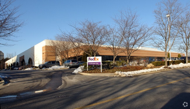
7331 Calhoun Pl, Derwood, MD 20855


Property Detail
7331 Calhoun Pl
04-03259358
PAR L GUDE NORTH
Warehouse
Montgomery
IM2.5
Maryland
B and X Area of moderate flood hazard, usually the area between the limits of the 100-year and 500-year floods.
l
2024
9.97 AC
2025
North Rockville
701211
Washington, DC
150,348 SF
Washington-Arlington-Alexandria, DC-VA-MD-WV
NEARBY LISTINGS FOR SALE OR LEASE
DEMOGRAPHICS near 7331 Calhoun Pl
1 mile
3 mile
5 mile
2025 Total Population
6,742
96,500
327,893
2030 Population
6,835
99,567
337,734
Pop Growth 2025-2030
+ 1.38%
+ 3.18%
+ 3.00%
Average Age
41
41
41
2025 Total Households
2,422
37,188
123,030
HH Growth 2025-2030
+ 1.16%
+ 3.27%
+ 3.08%
Median Household Inc
$114,270
$120,815
$117,261
Avg Household Size
2.70
2.50
2.60
2025 Avg HH Vehicles
2.00
2.00
2.00
Median Home Value
$648,296
$660,804
$633,125
Median Year Built
1984
1982
1982
Nearby Places
Map Layers
Map Styles
 Street
 Aerial
Layers
 Traffic
 Biking
Places
Listings with unknown addresses are not visible on the map
- Restaurants
- Banks
- Shops
- Fitness
- Groceries
PUBLIC TRANSPORTATION
COMMUTER RAIL
Rockville (Brunswick Line - Maryland Area Regional Commuter Trains (The MARC))
Drive
Walk
Distance
Rockville (Brunswick Line - Maryland Area Regional Commuter Trains (The MARC))
7 min
2.3 mi
Drive
Walk
Distance
8 min
3.1 mi
AIRPORT
Ronald Reagan Washington Ntl
Drive
Walk
Distance
Ronald Reagan Washington Ntl
44 min
21.8 mi
Washington Dulles International
Drive
Walk
Distance
Washington Dulles International
50 min
30.6 mi
Baltimore/Washington International Thurgood Marshall
Drive
Walk
Distance
Baltimore/Washington International Thurgood Marshall
51 min
36.7 mi
Freight Ports
Port of Baltimore
Drive
Walk
Distance
Port of Baltimore
55 min
39.4 mi
Nearby Properties
Address
Land Use
TOTAL SIZE
Lot Size
Zoning
Address
Land Use
TOTAL SIZE
Lot Size
Zoning
987,382 SF
5 AC
MXTD
Address
Land Use
TOTAL SIZE
Lot Size
Zoning
713,627 SF
38.49 AC
LSC1.
Address
Land Use
TOTAL SIZE
Lot Size
Zoning
1,136,684 SF
84.61 AC
R200
Address
Land Use
TOTAL SIZE
Lot Size
Zoning
668,337 SF
10.39 AC
LSC1.
Address
Land Use
TOTAL SIZE
Lot Size
Zoning
533,012 SF
18.08 AC
LSC1.
Address
Land Use
TOTAL SIZE
Lot Size
Zoning
978,527 SF
11.54 AC
03
Address
Land Use
TOTAL SIZE
Lot Size
Zoning
693,823 SF
5.30 AC
CR2.0
Address
Land Use
TOTAL SIZE
Lot Size
Zoning
461,295 SF
45.71 AC
LSC2.
Address
Land Use
TOTAL SIZE
Lot Size
Zoning
353,867 SF
11 AC
RS
Address
Land Use
TOTAL SIZE
Lot Size
Zoning
185,000 SF
2.60 AC
EOF
Address
Land Use
TOTAL SIZE
Lot Size
Zoning
434,440 SF
5.09 AC
CR1.5
Address
Land Use
TOTAL SIZE
Lot Size
Zoning
407,130 SF
4.62 AC
CRT1.
Address
Land Use
TOTAL SIZE
Lot Size
Zoning
363,750 SF
21.16 AC
R60
Address
Land Use
TOTAL SIZE
Lot Size
Zoning
370,422 SF
13.87 AC
CRT1.
Address
Land Use
TOTAL SIZE
Lot Size
Zoning
302,484 SF
4.99 AC
MXD
Address
Land Use
TOTAL SIZE
Lot Size
Zoning
315,000 SF
4.70 AC
CR1.5
Address
Land Use
TOTAL SIZE
Lot Size
Zoning
363,000 SF
4.37 AC
MXTD
Address
Land Use
TOTAL SIZE
Lot Size
Zoning
899,156 SF
6.05 AC
CD
Address
Land Use
TOTAL SIZE
Lot Size
Zoning
405,742 SF
14.48 AC
R30
Address
Land Use
TOTAL SIZE
Lot Size
Zoning
243,000 SF
2.10 AC
PD-KS
Address
Land Use
TOTAL SIZE
Lot Size
Zoning
385,641 SF
2.65 AC
MXD
Address
Land Use
TOTAL SIZE
Lot Size
Zoning
311,500 SF
29.05 AC
R60
Address
Land Use
TOTAL SIZE
Lot Size
Zoning
325,990 SF
51.21 AC
CRT07
Address
Land Use
TOTAL SIZE
Lot Size
Zoning
215,558 SF
13.74 AC
RS
Address
Land Use
TOTAL SIZE
Lot Size
Zoning
279,442 SF
9.78 AC
CRT1.
Address
Land Use
TOTAL SIZE
Lot Size
Zoning
289,485 SF
9.82 AC
RS
Address
Land Use
TOTAL SIZE
Lot Size
Zoning
316,883 SF
8.62 AC
OCPD
Address
Land Use
TOTAL SIZE
Lot Size
Zoning
19.50 AC
MXCD
Address
Land Use
TOTAL SIZE
Lot Size
Zoning
172,740 SF
6.93 AC
PD-RC
Address
Land Use
TOTAL SIZE
Lot Size
Zoning
17.64 AC
MXD
The World's #1 Commercial Real Estate Marketplace
Connect with us
© 2026 CoStar Group
The information above has been obtained from sources believed reliable. While we do not doubt its accuracy we have not verified it and make no guarantee, warranty or representation about it. It is your responsibility to independently confirm its accuracy and completeness. Any projections, opinions, assumptions, or estimates used are for example only and do not represent the current or future performance of the property. The value of this transaction to you depends on tax and other factors which should be evaluated by your tax, financial, and legal advisors. You and your advisors should conduct a careful, independent investigation of the property to determine to your satisfaction the suitability of the property for your needs.