Property Record
7331 Skyline Dr E, Columbus, OH 43235
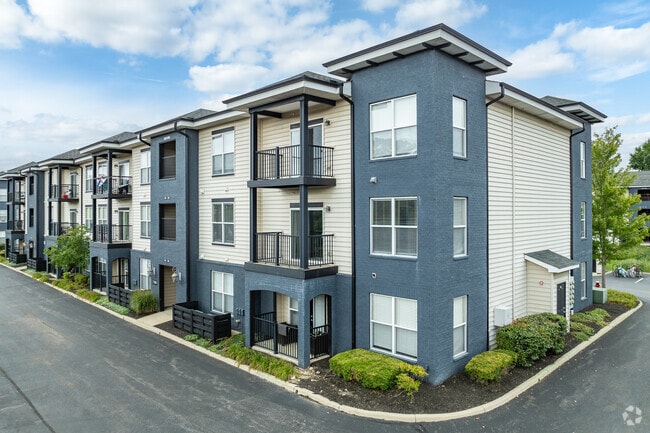

Property Detail
7331 Skyline Dr E
Columbus, OH
E SKYLINE DR SAWMILL RD OFFICE PARK PT LTS 3 & 7=5.679 ACRES
590-280514
FRANKLIN
Apartment
Ohio
B and X Area of moderate flood hazard, usually the area between the limits of the 100-year and 500-year floods.
3 7 5
2024
5.68 AC
2025
Brookside Colony
006386
Columbus
121,054 SF
NEARBY LISTINGS FOR SALE OR LEASE
-
-
View all Columbus listings for sale on LoopNet.com
DEMOGRAPHICS near 7331 Skyline Dr E
1 mile
3 mile
5 mile
2025 Total Population
15,065
89,685
238,488
2030 Population
15,439
91,872
246,472
Pop Growth 2025-2030
+ 2.48%
+ 2.44%
+ 3.35%
Average Age
37
39
39
2025 Total Households
6,772
36,671
99,239
HH Growth 2025-2030
+ 2.85%
+ 2.68%
+ 3.41%
Median Household Inc
$77,205
$101,298
$102,640
Avg Household Size
2.20
2.40
2.40
2025 Avg HH Vehicles
2.00
2.00
2.00
Median Home Value
$336,335
$399,398
$429,573
Median Year Built
1988
1986
1987
Nearby Places
Map Layers
Map Styles
 Street
 Aerial
Transit
 Traffic
 Biking
Places
Listings with unknown addresses are not visible on the map
- Restaurants
- Banks
- Shops
- Fitness
- Groceries
PUBLIC TRANSPORTATION
AIRPORT
John Glenn Columbus International
Drive
Walk
Distance
John Glenn Columbus International
27 min
19.7 mi
Rickenbacker International
Drive
Walk
Distance
Rickenbacker International
40 min
30.7 mi
Freight Ports
Port of Toledo
Drive
Walk
Distance
Port of Toledo
172 min
135.3 mi
Nearby Properties
Address
Land Use
TOTAL SIZE
Lot Size
Zoning
Address
Land Use
TOTAL SIZE
Lot Size
Zoning
182,845 SF
325.61 AC
Address
Land Use
TOTAL SIZE
Lot Size
Zoning
182,845 SF
325.61 AC
Address
Land Use
TOTAL SIZE
Lot Size
Zoning
133,425 SF
0.44 AC
Address
Land Use
TOTAL SIZE
Lot Size
Zoning
260,092 SF
29.05 AC
Address
Land Use
TOTAL SIZE
Lot Size
Zoning
297,024 SF
71.76 AC
Address
Land Use
TOTAL SIZE
Lot Size
Zoning
561,921 SF
6.81 AC
Address
Land Use
TOTAL SIZE
Lot Size
Zoning
557,021 SF
21.28 AC
Address
Land Use
TOTAL SIZE
Lot Size
Zoning
232,579 SF
54.30 AC
Address
Land Use
TOTAL SIZE
Lot Size
Zoning
173,618 SF
1.13 AC
Address
Land Use
TOTAL SIZE
Lot Size
Zoning
223,270 SF
1.30 AC
Address
Land Use
TOTAL SIZE
Lot Size
Zoning
261,872 SF
53.89 AC
Address
Land Use
TOTAL SIZE
Lot Size
Zoning
200,609 SF
21.87 AC
Address
Land Use
TOTAL SIZE
Lot Size
Zoning
178,568 SF
31.62 AC
Address
Land Use
TOTAL SIZE
Lot Size
Zoning
160,958 SF
11.93 AC
Address
Land Use
TOTAL SIZE
Lot Size
Zoning
115,032 SF
12.81 AC
Address
Land Use
TOTAL SIZE
Lot Size
Zoning
42,494 SF
0.19 AC
Address
Land Use
TOTAL SIZE
Lot Size
Zoning
414,372 SF
24.87 AC
Address
Land Use
TOTAL SIZE
Lot Size
Zoning
184,139 SF
20.57 AC
Address
Land Use
TOTAL SIZE
Lot Size
Zoning
257,993 SF
9.98 AC
Address
Land Use
TOTAL SIZE
Lot Size
Zoning
245,705 SF
6.50 AC
Address
Land Use
TOTAL SIZE
Lot Size
Zoning
323,955 SF
31.18 AC
Address
Land Use
TOTAL SIZE
Lot Size
Zoning
73,944 SF
11.03 AC
Address
Land Use
TOTAL SIZE
Lot Size
Zoning
162,728 SF
4.80 AC
Address
Land Use
TOTAL SIZE
Lot Size
Zoning
115,392 SF
25 AC
Address
Land Use
TOTAL SIZE
Lot Size
Zoning
216,100 SF
28.17 AC
Address
Land Use
TOTAL SIZE
Lot Size
Zoning
168,323 SF
22.61 AC
Address
Land Use
TOTAL SIZE
Lot Size
Zoning
111,376 SF
0.55 AC
Address
Land Use
TOTAL SIZE
Lot Size
Zoning
122,663 SF
0.60 AC
Address
Land Use
TOTAL SIZE
Lot Size
Zoning
123,149 SF
12.09 AC
Address
Land Use
TOTAL SIZE
Lot Size
Zoning
86,934 SF
8.80 AC
The World's #1 Commercial Real Estate Marketplace
Connect with us
© 2026 CoStar Group
The information above has been obtained from sources believed reliable. While we do not doubt its accuracy we have not verified it and make no guarantee, warranty or representation about it. It is your responsibility to independently confirm its accuracy and completeness. Any projections, opinions, assumptions, or estimates used are for example only and do not represent the current or future performance of the property. The value of this transaction to you depends on tax and other factors which should be evaluated by your tax, financial, and legal advisors. You and your advisors should conduct a careful, independent investigation of the property to determine to your satisfaction the suitability of the property for your needs.