Property Record
7334 Navarre Pkwy, Navarre, FL 32566
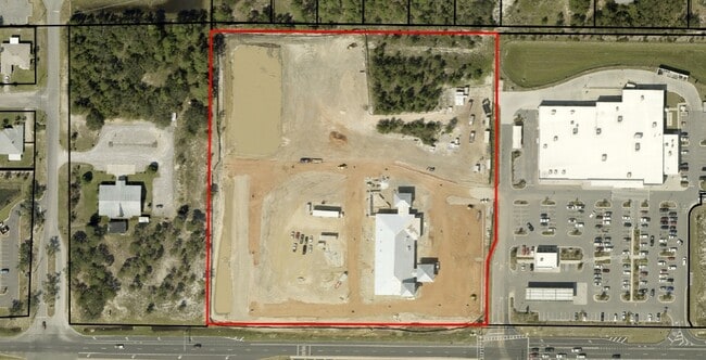
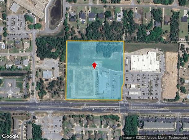
This Property Is For Sale
NEARBY LISTINGS FOR SALE OR LEASE
-
-
View all Navarre listings for sale on LoopNet.com
Property Detail
7334 Navarre Pkwy
24-2S-27-0000-00101-0000
COM AT NE CORNER OF SECTION 24 TOWNSHP 2 SOUTH RANGE 27 WEST THN S8*5727E ALONG E SEC LN 2641.54 FT THN S80*2904W 4043.63 FT TO POB & CONT 1237. 31 FT TO W SEC LN THN S9*2258 E 637.66 FT TO N R/W OF HWY 98 THN N80*1634E ON HWY 1231 .10 FT THN N8*4908
Hospitalpublic
Santa Rosa
X
Florida
12113C0568H
9.10 AC
2024
Navarre
2025
Pensacola
010821
Pensacola-Ferry Pass-Brent, FL
19,350 SF
DEMOGRAPHICS near 7334 Navarre Pkwy
1 Mile
3 Mile
5 Mile
2024 Total Population
5,583
31,029
52,484
2029 Population
6,380
35,831
60,954
Pop Growth 2024-2029
+ 14.28%
+ 15.48%
+ 16.14%
Average Age
38
40
40
2024 Total Households
2,150
11,650
19,900
HH Growth 2024-2029
+ 14.65%
+ 16.03%
+ 16.71%
Median Household Inc
$92,704
$93,863
$92,453
Avg Household Size
2.60
2.60
2.60
2024 Avg HH Vehicles
2.00
2.00
2.00
Median Home Value
$276,044
$311,096
$317,745
Median Year Built
2002
2003
2002
Nearby Places
Map Layers
Map Styles
 Street
 Aerial
- Restaurants
- Banks
- Shops
- Fitness
- Groceries
PUBLIC TRANSPORTATION
AIRPORT
Pensacola International
DRIVE
WALK
Distance
Pensacola International
46 min
26.7 mi
Eglin AFB/Destin-Ft Walton Beach
DRIVE
WALK
Distance
Eglin AFB/Destin-Ft Walton Beach
57 min
29.5 mi
Freight Ports
Port of Mobile
DRIVE
WALK
Distance
Port of Mobile
99 min
82.5 mi
Nearby Properties
Address
Land Use
TOTAL SIZE
Lot Size
Zoning
Address
Land Use
TOTAL SIZE
Lot Size
Zoning
344,974 SF
16.11 AC
R3
Address
Land Use
TOTAL SIZE
Lot Size
Zoning
375,552 SF
10.62 AC
PBD
Address
Land Use
TOTAL SIZE
Lot Size
Zoning
242,842 SF
14.77 AC
PBD
Address
Land Use
TOTAL SIZE
Lot Size
Zoning
241,693 SF
14.28 AC
PBD
Address
Land Use
TOTAL SIZE
Lot Size
Zoning
23.12 AC
C
Address
Land Use
TOTAL SIZE
Lot Size
Zoning
161,438 SF
5.64 AC
HCD
Address
Land Use
TOTAL SIZE
Lot Size
Zoning
68,134 SF
21.16 AC
R1
Address
Land Use
TOTAL SIZE
Lot Size
Zoning
116,452 SF
4.55 AC
HCD
Address
Land Use
TOTAL SIZE
Lot Size
Zoning
65,936 SF
1.86 AC
PBD
Address
Land Use
TOTAL SIZE
Lot Size
Zoning
51,677 SF
17.79 AC
PBD
Address
Land Use
TOTAL SIZE
Lot Size
Zoning
68,334 SF
4.45 AC
HCD
Address
Land Use
TOTAL SIZE
Lot Size
Zoning
85,562 SF
36.21 AC
PBD
Address
Land Use
TOTAL SIZE
Lot Size
Zoning
60,854 SF
7.07 AC
HCD
Address
Land Use
TOTAL SIZE
Lot Size
Zoning
48,198 SF
1.76 AC
PBD
Address
Land Use
TOTAL SIZE
Lot Size
Zoning
130,030 SF
36.74 AC
R1A
Address
Land Use
TOTAL SIZE
Lot Size
Zoning
39,373 SF
185.18 AC
R1
Address
Land Use
TOTAL SIZE
Lot Size
Zoning
2,046 SF
0.79 AC
HCD
Address
Land Use
TOTAL SIZE
Lot Size
Zoning
36,749 SF
2.75 AC
HCD
Address
Land Use
TOTAL SIZE
Lot Size
Zoning
16,151 SF
2.53 AC
HCD
Address
Land Use
TOTAL SIZE
Lot Size
Zoning
13,716 SF
1.14 AC
HCD
Address
Land Use
TOTAL SIZE
Lot Size
Zoning
24,180 SF
4.07 AC
HCD
Address
Land Use
TOTAL SIZE
Lot Size
Zoning
18,054 SF
1.47 AC
HCD
Address
Land Use
TOTAL SIZE
Lot Size
Zoning
9,106 SF
1.76 AC
HCD
Address
Land Use
TOTAL SIZE
Lot Size
Zoning
10,506 SF
0.67 AC
PBD
Address
Land Use
TOTAL SIZE
Lot Size
Zoning
13,099 SF
1.24 AC
HCD
The World's #1 Commercial Real Estate Marketplace
Connect with us
© 2026 CoStar Group
The information above has been obtained from sources believed reliable. While we do not doubt its accuracy we have not verified it and make no guarantee, warranty or representation about it. It is your responsibility to independently confirm its accuracy and completeness. Any projections, opinions, assumptions, or estimates used are for example only and do not represent the current or future performance of the property. The value of this transaction to you depends on tax and other factors which should be evaluated by your tax, financial, and legal advisors. You and your advisors should conduct a careful, independent investigation of the property to determine to your satisfaction the suitability of the property for your needs.