Property Record
7337 N El Mirage Rd, Glendale, AZ 85307
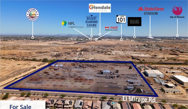
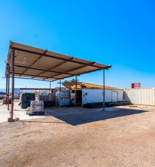
This Property Is For Sale
NEARBY LISTINGS FOR SALE OR LEASE
Property Detail
7337 N El Mirage Rd
501-54-004L
NW4 SW4 SEC 1 EX N 130F OF W 1050F TH/OF & EX S 595F TH/OF & EX W 33F RD & EX TH PT N 160F OF W 1090F NW4 SW4 SEC 1 CONV TO FLOOD CONTROL DIST PF 94-861684 & EX ANY PT LY WI/IN FOL DESC RD COM W4 COR SEC 1 TH S 01D 35M E 160.10F POB TH S 01D 35M E 95
Miningfacilityoilgasmineralpreciousmetals
Maricopa
AE
Arizona
04013C1690M
16.86 AC
2025
Loop 303/Surprise
2025
Phoenix
061011
Phoenix-Mesa-Scottsdale, AZ
DEMOGRAPHICS near 7337 N El Mirage Rd
1 Mile
3 Mile
5 Mile
2024 Total Population
3,292
45,425
208,322
2029 Population
3,607
47,844
218,379
Pop Growth 2024-2029
+ 9.57%
+ 5.33%
+ 4.83%
Average Age
35
37
39
2024 Total Households
979
15,635
72,692
HH Growth 2024-2029
+ 9.70%
+ 5.74%
+ 4.95%
Median Household Inc
$132,525
$82,962
$81,933
Avg Household Size
3.20
2.80
2.80
2024 Avg HH Vehicles
2.00
2.00
2.00
Median Home Value
$469,557
$401,259
$390,048
Median Year Built
2010
2001
2000
Nearby Places
- Restaurants
- Banks
- Shops
- Fitness
- Groceries
PUBLIC TRANSPORTATION
AIRPORT
Phoenix Sky Harbor International
DRIVE
WALK
Distance
Phoenix Sky Harbor International
36 min
26.2 mi
Freight Ports
Port of San Diego
DRIVE
WALK
Distance
Port of San Diego
388 min
346.0 mi
Nearby Properties
Address
Land Use
TOTAL SIZE
Lot Size
Zoning
Address
Land Use
TOTAL SIZE
Lot Size
Zoning
138.98 AC
Address
Land Use
TOTAL SIZE
Lot Size
Zoning
71.40 AC
Address
Land Use
TOTAL SIZE
Lot Size
Zoning
35.74 AC
Address
Land Use
TOTAL SIZE
Lot Size
Zoning
303,419 SF
31.47 AC
Address
Land Use
TOTAL SIZE
Lot Size
Zoning
127,011 SF
30.62 AC
PAD
Address
Land Use
TOTAL SIZE
Lot Size
Zoning
1,188,764 SF
631.19 AC
AP
Address
Land Use
TOTAL SIZE
Lot Size
Zoning
0.68 AC
Address
Land Use
TOTAL SIZE
Lot Size
Zoning
1,433,378 SF
317.58 AC
AP
Address
Land Use
TOTAL SIZE
Lot Size
Zoning
52.99 AC
Address
Land Use
TOTAL SIZE
Lot Size
Zoning
510,342 SF
51.45 AC
LUKEAFB
Address
Land Use
TOTAL SIZE
Lot Size
Zoning
844,524 SF
130.66 AC
LUKEAFB
Address
Land Use
TOTAL SIZE
Lot Size
Zoning
351,775 SF
53.72 AC
AP
Address
Land Use
TOTAL SIZE
Lot Size
Zoning
185,870 SF
125.41 AC
S1
Address
Land Use
TOTAL SIZE
Lot Size
Zoning
531,110 SF
124.24 AC
I-1
Address
Land Use
TOTAL SIZE
Lot Size
Zoning
294,360 SF
21.69 AC
EI
Address
Land Use
TOTAL SIZE
Lot Size
Zoning
291,028 SF
20.62 AC
Address
Land Use
TOTAL SIZE
Lot Size
Zoning
327,311 SF
21.14 AC
RM-1
Address
Land Use
TOTAL SIZE
Lot Size
Zoning
113,020 SF
16.37 AC
R-43
Address
Land Use
TOTAL SIZE
Lot Size
Zoning
242,740 SF
20.21 AC
M1
Address
Land Use
TOTAL SIZE
Lot Size
Zoning
102,431 SF
17.63 AC
R-10
Address
Land Use
TOTAL SIZE
Lot Size
Zoning
181,897 SF
16.71 AC
R-43AG
Address
Land Use
TOTAL SIZE
Lot Size
Zoning
120,289 SF
13.69 AC
C-S
Address
Land Use
TOTAL SIZE
Lot Size
Zoning
93,832 SF
79 AC
AG
Address
Land Use
TOTAL SIZE
Lot Size
Zoning
3,237 SF
1.09 AC
I-1
Address
Land Use
TOTAL SIZE
Lot Size
Zoning
251,600 SF
15.56 AC
Address
Land Use
TOTAL SIZE
Lot Size
Zoning
82,153 SF
14.22 AC
R-43
Address
Land Use
TOTAL SIZE
Lot Size
Zoning
116,323 SF
17.38 AC
R-8
Address
Land Use
TOTAL SIZE
Lot Size
Zoning
91,600 SF
18.61 AC
R-43
Address
Land Use
TOTAL SIZE
Lot Size
Zoning
152,254 SF
13.49 AC
C2
Address
Land Use
TOTAL SIZE
Lot Size
Zoning
82,320 SF
36.07 AC
AP
The World's #1 Commercial Real Estate Marketplace
Connect with us
© 2025 CoStar Group
The information above has been obtained from sources believed reliable. While we do not doubt its accuracy we have not verified it and make no guarantee, warranty or representation about it. It is your responsibility to independently confirm its accuracy and completeness. Any projections, opinions, assumptions, or estimates used are for example only and do not represent the current or future performance of the property. The value of this transaction to you depends on tax and other factors which should be evaluated by your tax, financial, and legal advisors. You and your advisors should conduct a careful, independent investigation of the property to determine to your satisfaction the suitability of the property for your needs.