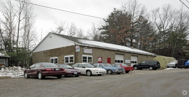
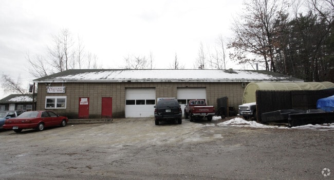
Property Record
734A Daniel Webster Hwy, Merrimack, NH 03054
NEARBY LISTINGS FOR SALE OR LEASE
Property Detail
734A Daniel Webster Hwy
MRMK-000007E-000031
Hillsborough
Commercialnec
New Hampshire
X
31
33011C0389D
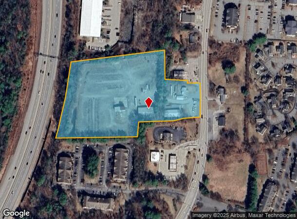
6.93 AC
2024
Hillsborough
2024
Boston
014101
Manchester-Nashua, NH
4,860 SF
DEMOGRAPHICS near 734A Daniel Webster Hwy
1 Mile
3 Mile
5 Mile
2024 Total Population
3,898
22,636
78,409
2029 Population
3,997
23,189
80,592
Pop Growth 2024-2029
+ 2.54%
+ 2.44%
+ 2.78%
Average Age
41
42
42
2024 Total Households
1,615
8,688
29,956
HH Growth 2024-2029
+ 2.54%
+ 2.47%
+ 2.81%
Median Household Inc
$77,457
$108,660
$104,956
Avg Household Size
2.30
2.50
2.50
2024 Avg HH Vehicles
2.00
2.00
2.00
Median Home Value
$275,355
$364,942
$372,695
Median Year Built
1982
1984
1983
Nearby Places
Map Layers
Map Styles
 Street
 Aerial
- Restaurants
- Banks
- Shops
- Fitness
- Groceries
PUBLIC TRANSPORTATION
AIRPORT
Manchester Boston Regional
DRIVE
WALK
Distance
Manchester Boston Regional
8 min
3.3 mi
Freight Ports
Port of Boston
DRIVE
WALK
Distance
Port of Boston
82 min
60.2 mi
Nearby Properties
Address
Land Use
TOTAL SIZE
Lot Size
Zoning
Address
Land Use
TOTAL SIZE
Lot Size
Zoning
768,020 SF
74.47 AC
I-II
Address
Land Use
TOTAL SIZE
Lot Size
Zoning
603,357 SF
45.12 AC
GB
Address
Land Use
TOTAL SIZE
Lot Size
Zoning
56,997 SF
31.28 AC
INDUST
Address
Land Use
TOTAL SIZE
Lot Size
Zoning
46,906 SF
552.35 AC
Address
Land Use
TOTAL SIZE
Lot Size
Zoning
29,803 SF
31.46 AC
PZ
Address
Land Use
TOTAL SIZE
Lot Size
Zoning
3,748 SF
14.69 AC
Address
Land Use
TOTAL SIZE
Lot Size
Zoning
0.60 AC
PZ
Address
Land Use
TOTAL SIZE
Lot Size
Zoning
42,228 SF
15.58 AC
PZ
Address
Land Use
TOTAL SIZE
Lot Size
Zoning
50.47 AC
GB
Address
Land Use
TOTAL SIZE
Lot Size
Zoning
723,875 SF
38.08 AC
Address
Land Use
TOTAL SIZE
Lot Size
Zoning
201,831 SF
18.46 AC
IND-II
Address
Land Use
TOTAL SIZE
Lot Size
Zoning
151,002 SF
6.95 AC
PZ
Address
Land Use
TOTAL SIZE
Lot Size
Zoning
142,318 SF
26.13 AC
GB
Address
Land Use
TOTAL SIZE
Lot Size
Zoning
227,589 SF
GB
Address
Land Use
TOTAL SIZE
Lot Size
Zoning
244,637 SF
27.28 AC
IND-II
Address
Land Use
TOTAL SIZE
Lot Size
Zoning
304,312 SF
29.62 AC
IND-II
Address
Land Use
TOTAL SIZE
Lot Size
Zoning
13,395 SF
8.16 AC
PZ
Address
Land Use
TOTAL SIZE
Lot Size
Zoning
116.34 AC
IND-II
Address
Land Use
TOTAL SIZE
Lot Size
Zoning
192,520 SF
34.20 AC
Address
Land Use
TOTAL SIZE
Lot Size
Zoning
187,046 SF
17.40 AC
PZ
Address
Land Use
TOTAL SIZE
Lot Size
Zoning
24.20 AC
GB
Address
Land Use
TOTAL SIZE
Lot Size
Zoning
124,836 SF
28.60 AC
Address
Land Use
TOTAL SIZE
Lot Size
Zoning
97,405 SF
14.40 AC
PZ
Address
Land Use
TOTAL SIZE
Lot Size
Zoning
146,997 SF
16.88 AC
Address
Land Use
TOTAL SIZE
Lot Size
Zoning
122,900 SF
13.28 AC
PZ
Address
Land Use
TOTAL SIZE
Lot Size
Zoning
5,894 SF
12.50 AC
RESIDE
Address
Land Use
TOTAL SIZE
Lot Size
Zoning
132,353 SF
15.52 AC
PZ
Address
Land Use
TOTAL SIZE
Lot Size
Zoning
94,419 SF
6 AC
Address
Land Use
TOTAL SIZE
Lot Size
Zoning
69,045 SF
35 AC
RESIDE
Address
Land Use
TOTAL SIZE
Lot Size
Zoning
107,615 SF
13.34 AC
PZ
The World's #1 Commercial Real Estate Marketplace
Connect with us
© 2025 CoStar Group
The information above has been obtained from sources believed reliable. While we do not doubt its accuracy we have not verified it and make no guarantee, warranty or representation about it. It is your responsibility to independently confirm its accuracy and completeness. Any projections, opinions, assumptions, or estimates used are for example only and do not represent the current or future performance of the property. The value of this transaction to you depends on tax and other factors which should be evaluated by your tax, financial, and legal advisors. You and your advisors should conduct a careful, independent investigation of the property to determine to your satisfaction the suitability of the property for your needs.