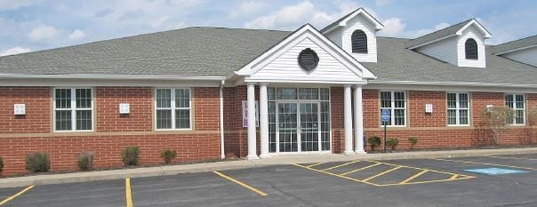
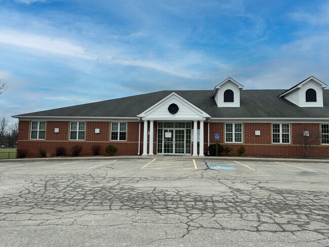
Property Record
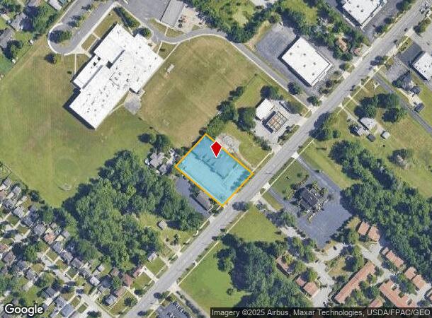
7340 Pearl Rd, Cleveland, OH 44130

NEARBY LISTINGS FOR SALE OR LEASE
Property Detail
7340 Pearl Rd
Cleveland-Elyria, OH
Add
373-26-043
PCL A VOL 335 PG 39 FF 184.50 D 254.80 1.078AC OL 18 ADDITIONAL PARCEL 37326073 AND 074 2005S/R
Officebuilding
Cuyahoga
X
Ohio
39035C0281E
18
2024
1.08 AC
2024
Southwest
173107
Cleveland
13,356 SF
DEMOGRAPHICS near 7340 Pearl Rd
1 Mile
3 Mile
5 Mile
2024 Total Population
7,485
70,966
178,925
2029 Population
7,255
68,965
173,963
Pop Growth 2024-2029
(3.07%)
(2.82%)
(2.77%)
Average Age
44
44
43
2024 Total Households
3,229
30,597
77,493
HH Growth 2024-2029
(3.31%)
(3.02%)
(2.98%)
Median Household Inc
$70,333
$66,325
$66,033
Avg Household Size
2.20
2.20
2.20
2024 Avg HH Vehicles
2.00
2.00
2.00
Median Home Value
$182,284
$168,629
$170,391
Median Year Built
1964
1964
1964
Nearby Places
Map Layers
Map Styles
 Street
 Aerial
- Restaurants
- Banks
- Shops
- Fitness
- Groceries
PUBLIC TRANSPORTATION
AIRPORT
Cleveland-Hopkins International
DRIVE
WALK
Distance
Cleveland-Hopkins International
16 min
7.1 mi
Akron-Canton Regional
DRIVE
WALK
Distance
Akron-Canton Regional
62 min
48.2 mi
SALE & LEASE HISTORY
LISTING DATE
SALE/LEASE

Sep 25, 2016
For Lease
Feb 23, 2021
For Lease
Feb 05, 2025
For Lease
Nearby Properties
Address
Land Use
TOTAL SIZE
Lot Size
Zoning
Address
Land Use
TOTAL SIZE
Lot Size
Zoning
1,490,538 SF
19.29 AC
PF
Address
Land Use
TOTAL SIZE
Lot Size
Zoning
237,144 SF
2.12 AC
PG
Address
Land Use
TOTAL SIZE
Lot Size
Zoning
668,882 SF
41.27 AC
SC
Address
Land Use
TOTAL SIZE
Lot Size
Zoning
1,514 SF
23.65 AC
RSF-B
Address
Land Use
TOTAL SIZE
Lot Size
Zoning
208.22 AC
U5-A
Address
Land Use
TOTAL SIZE
Lot Size
Zoning
725,585 SF
76.92 AC
SF-A
Address
Land Use
TOTAL SIZE
Lot Size
Zoning
289,215 SF
20.56 AC
RSF-B
Address
Land Use
TOTAL SIZE
Lot Size
Zoning
768,485 SF
14.53 AC
R1-A
Address
Land Use
TOTAL SIZE
Lot Size
Zoning
168,729 SF
11.56 AC
GB
Address
Land Use
TOTAL SIZE
Lot Size
Zoning
88.28 AC
U5-A
Address
Land Use
TOTAL SIZE
Lot Size
Zoning
244,717 SF
23.97 AC
RMF-1
Address
Land Use
TOTAL SIZE
Lot Size
Zoning
505,418 SF
33.99 AC
SC
Address
Land Use
TOTAL SIZE
Lot Size
Zoning
299,114 SF
23.65 AC
RSF-B
Address
Land Use
TOTAL SIZE
Lot Size
Zoning
126,000 SF
3.02 AC
PG
Address
Land Use
TOTAL SIZE
Lot Size
Zoning
309,231 SF
34.28 AC
Address
Land Use
TOTAL SIZE
Lot Size
Zoning
364,000 SF
33.27 AC
U5-A
Address
Land Use
TOTAL SIZE
Lot Size
Zoning
174.94 AC
U5-A
Address
Land Use
TOTAL SIZE
Lot Size
Zoning
300,120 SF
20.18 AC
GI
Address
Land Use
TOTAL SIZE
Lot Size
Zoning
263,867 SF
59.28 AC
PF
Address
Land Use
TOTAL SIZE
Lot Size
Zoning
426.60 AC
PF
Address
Land Use
TOTAL SIZE
Lot Size
Zoning
166,104 SF
4.70 AC
CC
Address
Land Use
TOTAL SIZE
Lot Size
Zoning
107,427 SF
30 AC
SF-A
Address
Land Use
TOTAL SIZE
Lot Size
Zoning
334,360 SF
8.22 AC
MF-HD
Address
Land Use
TOTAL SIZE
Lot Size
Zoning
263,926 SF
95.55 AC
GI
Address
Land Use
TOTAL SIZE
Lot Size
Zoning
78,000 SF
5.78 AC
OB
Address
Land Use
TOTAL SIZE
Lot Size
Zoning
275,274 SF
16.91 AC
RMF-1
Address
Land Use
TOTAL SIZE
Lot Size
Zoning
110,648 SF
10.79 AC
SR/LC
Address
Land Use
TOTAL SIZE
Lot Size
Zoning
315,434 SF
3.48 AC
A
Address
Land Use
TOTAL SIZE
Lot Size
Zoning
113,100 SF
7.80 AC
GB
Address
Land Use
TOTAL SIZE
Lot Size
Zoning
59,296 SF
7.08 AC
CC
The World's #1 Commercial Real Estate Marketplace
Connect with us
© 2025 CoStar Group
The information above has been obtained from sources believed reliable. While we do not doubt its accuracy we have not verified it and make no guarantee, warranty or representation about it. It is your responsibility to independently confirm its accuracy and completeness. Any projections, opinions, assumptions, or estimates used are for example only and do not represent the current or future performance of the property. The value of this transaction to you depends on tax and other factors which should be evaluated by your tax, financial, and legal advisors. You and your advisors should conduct a careful, independent investigation of the property to determine to your satisfaction the suitability of the property for your needs.