Property Record
735 Baldwin Ave, Pontiac, MI 48340
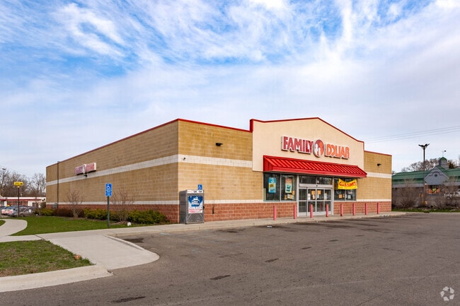
Property Detail
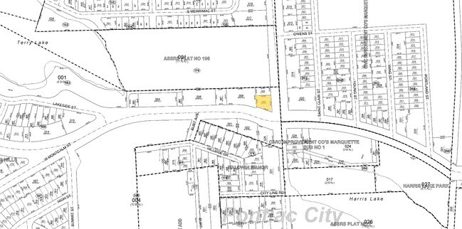
735 Baldwin Ave
14-20-176-008
T3N, R10E, SEC 20 BALDWIN-DIXIE HILLS LOTS 581, 582 & 583, ALSO E 1/2 OF VAC ALLEY ADJ TO SAME
Storebuilding
Oakland
BV
Michigan
B and X Area of moderate flood hazard, usually the area between the limits of the 100-year and 500-year floods.
581-583
2025
0.62 AC
2025
Pontiac
141400
Detroit
8,320 SF
Detroit-Warren-Dearborn, MI
NEARBY LISTINGS FOR SALE OR LEASE
DEMOGRAPHICS near 735 Baldwin Ave
1 mile
3 mile
5 mile
2025 Total Population
10,936
80,779
170,880
2030 Population
11,227
83,945
176,588
Pop Growth 2025-2030
+ 2.66%
+ 3.92%
+ 3.34%
Average Age
37
39
40
2025 Total Households
3,850
32,782
70,904
HH Growth 2025-2030
+ 2.75%
+ 3.94%
+ 3.40%
Median Household Inc
$52,710
$48,255
$64,625
Avg Household Size
2.60
2.30
2.30
2025 Avg HH Vehicles
2.00
2.00
2.00
Median Home Value
$82,445
$143,867
$226,084
Median Year Built
1954
1962
1970
Nearby Places
Map Layers
Map Styles
 Street
 Aerial
Layers
 Traffic
 Biking
Places
Listings with unknown addresses are not visible on the map
- Restaurants
- Banks
- Shops
- Fitness
- Groceries
PUBLIC TRANSPORTATION
COMMUTER RAIL
Pontiac Amtrak Station (Wolverine - Amtrak)
Drive
Walk
Distance
Pontiac Amtrak Station (Wolverine - Amtrak)
5 min
2.0 mi
Freight Ports
Port of Toledo
Drive
Walk
Distance
Port of Toledo
111 min
83.8 mi
Nearby Properties
Address
Land Use
TOTAL SIZE
Lot Size
Zoning
Address
Land Use
TOTAL SIZE
Lot Size
Zoning
2,734,739 SF
80.39 AC
Address
Land Use
TOTAL SIZE
Lot Size
Zoning
715,400 SF
Address
Land Use
TOTAL SIZE
Lot Size
Zoning
1,771,589 SF
96.73 AC
Address
Land Use
TOTAL SIZE
Lot Size
Zoning
426,034 SF
24.99 AC
AI
Address
Land Use
TOTAL SIZE
Lot Size
Zoning
144,349 SF
12.42 AC
SP
Address
Land Use
TOTAL SIZE
Lot Size
Zoning
199,125 SF
47.43 AC
Address
Land Use
TOTAL SIZE
Lot Size
Zoning
205,703 SF
21.63 AC
B2
Address
Land Use
TOTAL SIZE
Lot Size
Zoning
186,197 SF
12.11 AC
TR
Address
Land Use
TOTAL SIZE
Lot Size
Zoning
102,379 SF
28.20 AC
Address
Land Use
TOTAL SIZE
Lot Size
Zoning
79,263 SF
22.27 AC
Address
Land Use
TOTAL SIZE
Lot Size
Zoning
174,265 SF
13.50 AC
TR
Address
Land Use
TOTAL SIZE
Lot Size
Zoning
157,589 SF
5.21 AC
Address
Land Use
TOTAL SIZE
Lot Size
Zoning
71,140 SF
Address
Land Use
TOTAL SIZE
Lot Size
Zoning
109,556 SF
7.21 AC
Address
Land Use
TOTAL SIZE
Lot Size
Zoning
1,870,974 SF
61.73 AC
Address
Land Use
TOTAL SIZE
Lot Size
Zoning
100,169 SF
9.74 AC
TR
Address
Land Use
TOTAL SIZE
Lot Size
Zoning
88,734 SF
16 AC
TR
Address
Land Use
TOTAL SIZE
Lot Size
Zoning
337,677 SF
16.70 AC
AI
Address
Land Use
TOTAL SIZE
Lot Size
Zoning
150,090 SF
11.74 AC
I1
Address
Land Use
TOTAL SIZE
Lot Size
Zoning
136,544 SF
13.32 AC
I1
Address
Land Use
TOTAL SIZE
Lot Size
Zoning
142,997 SF
7.69 AC
I1
Address
Land Use
TOTAL SIZE
Lot Size
Zoning
94,184 SF
12 AC
TR
Address
Land Use
TOTAL SIZE
Lot Size
Zoning
128,010 SF
9.56 AC
TR
Address
Land Use
TOTAL SIZE
Lot Size
Zoning
143,701 SF
9.85 AC
AI
Address
Land Use
TOTAL SIZE
Lot Size
Zoning
69,980 SF
3.97 AC
Address
Land Use
TOTAL SIZE
Lot Size
Zoning
93,555 SF
3.15 AC
AI
Address
Land Use
TOTAL SIZE
Lot Size
Zoning
137,256 SF
14.97 AC
BI
Address
Land Use
TOTAL SIZE
Lot Size
Zoning
107,464 SF
11.49 AC
B2
Address
Land Use
TOTAL SIZE
Lot Size
Zoning
1,332,530 SF
95.81 AC
Address
Land Use
TOTAL SIZE
Lot Size
Zoning
147,264 SF
11.32 AC
TR
The World's #1 Commercial Real Estate Marketplace
Connect with us
© 2026 CoStar Group
The information above has been obtained from sources believed reliable. While we do not doubt its accuracy we have not verified it and make no guarantee, warranty or representation about it. It is your responsibility to independently confirm its accuracy and completeness. Any projections, opinions, assumptions, or estimates used are for example only and do not represent the current or future performance of the property. The value of this transaction to you depends on tax and other factors which should be evaluated by your tax, financial, and legal advisors. You and your advisors should conduct a careful, independent investigation of the property to determine to your satisfaction the suitability of the property for your needs.