Property Record
735 Upper St, Arlington, IA 50606
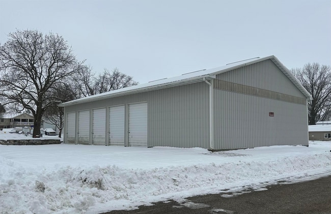

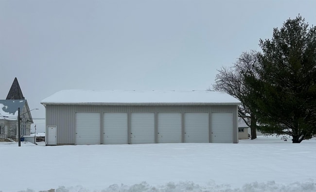
This Property Is For Sale
NEARBY LISTINGS FOR SALE OR LEASE
-
-
View all Arlington listings for sale on LoopNet.com
Property Detail
735 Upper St
16-28-454-009
Arlington
Publicstorage
LOT 70 BLK 4 ARLINGTON ADD.
X
Fayette
19065C0475E
Iowa
2024
70
2025
0.29 AC
080200
Iowa Northeast Area
3,360 SF
Other Market Areas
DEMOGRAPHICS near 735 Upper St
1 Mile
3 Mile
5 Mile
2024 Total Population
453
586
844
2029 Population
454
586
840
Pop Growth 2024-2029
+ 0.22%
0.00%
(0.47%)
Average Age
44
45
45
2024 Total Households
199
257
369
HH Growth 2024-2029
0.00%
(0.39%)
(0.54%)
Median Household Inc
$46,875
$48,249
$51,042
Avg Household Size
2.30
2.30
2.30
2024 Avg HH Vehicles
2.00
2.00
2.00
Median Home Value
$139,230
$144,805
$158,415
Median Year Built
1958
1954
1952
Nearby Places
Map Layers
Map Styles
 Street
 Aerial
- Restaurants
- Banks
- Shops
- Fitness
- Groceries
Nearby Properties
Address
Land Use
TOTAL SIZE
Lot Size
Zoning
Address
Land Use
TOTAL SIZE
Lot Size
Zoning
8,246 SF
1.85 AC
Address
Land Use
TOTAL SIZE
Lot Size
Zoning
153.83 AC
Address
Land Use
TOTAL SIZE
Lot Size
Zoning
157.57 AC
Address
Land Use
TOTAL SIZE
Lot Size
Zoning
4,800 SF
16.29 AC
Address
Land Use
TOTAL SIZE
Lot Size
Zoning
153.74 AC
Address
Land Use
TOTAL SIZE
Lot Size
Zoning
5,056 SF
0.90 AC
Address
Land Use
TOTAL SIZE
Lot Size
Zoning
152.81 AC
Address
Land Use
TOTAL SIZE
Lot Size
Zoning
151.22 AC
Address
Land Use
TOTAL SIZE
Lot Size
Zoning
147.50 AC
Address
Land Use
TOTAL SIZE
Lot Size
Zoning
149.22 AC
Address
Land Use
TOTAL SIZE
Lot Size
Zoning
3.60 AC
Address
Land Use
TOTAL SIZE
Lot Size
Zoning
165.01 AC
Address
Land Use
TOTAL SIZE
Lot Size
Zoning
153.13 AC
Address
Land Use
TOTAL SIZE
Lot Size
Zoning
117.67 AC
Address
Land Use
TOTAL SIZE
Lot Size
Zoning
600 SF
116.30 AC
Address
Land Use
TOTAL SIZE
Lot Size
Zoning
115.97 AC
Address
Land Use
TOTAL SIZE
Lot Size
Zoning
108.50 AC
Address
Land Use
TOTAL SIZE
Lot Size
Zoning
111.57 AC
Address
Land Use
TOTAL SIZE
Lot Size
Zoning
4.36 AC
Address
Land Use
TOTAL SIZE
Lot Size
Zoning
81.91 AC
Address
Land Use
TOTAL SIZE
Lot Size
Zoning
137.51 AC
Address
Land Use
TOTAL SIZE
Lot Size
Zoning
113.40 AC
Address
Land Use
TOTAL SIZE
Lot Size
Zoning
76.34 AC
Address
Land Use
TOTAL SIZE
Lot Size
Zoning
77.87 AC
Address
Land Use
TOTAL SIZE
Lot Size
Zoning
76.58 AC
Address
Land Use
TOTAL SIZE
Lot Size
Zoning
74.54 AC
Address
Land Use
TOTAL SIZE
Lot Size
Zoning
82.26 AC
Address
Land Use
TOTAL SIZE
Lot Size
Zoning
3,358 SF
0.27 AC
Address
Land Use
TOTAL SIZE
Lot Size
Zoning
78.83 AC
Address
Land Use
TOTAL SIZE
Lot Size
Zoning
7,320 SF
2.69 AC
The World's #1 Commercial Real Estate Marketplace
Connect with us
© 2026 CoStar Group
The information above has been obtained from sources believed reliable. While we do not doubt its accuracy we have not verified it and make no guarantee, warranty or representation about it. It is your responsibility to independently confirm its accuracy and completeness. Any projections, opinions, assumptions, or estimates used are for example only and do not represent the current or future performance of the property. The value of this transaction to you depends on tax and other factors which should be evaluated by your tax, financial, and legal advisors. You and your advisors should conduct a careful, independent investigation of the property to determine to your satisfaction the suitability of the property for your needs.