Property Record
7350 Fm 112, Thrall, TX 76578

Property Detail
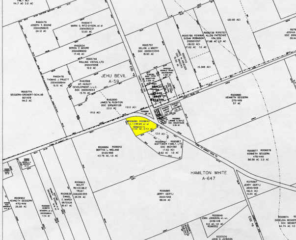
7350 Fm 112
R475110
AW0647 AW0647 - WHITE, H. SUR., ACRES 3.19
Taxexempt
WILLIAMSON
B and X Area of moderate flood hazard, usually the area between the limits of the 100-year and 500-year floods.
Texas
2023
3.19 AC
2025
Round Rock
020900
Austin
1,626 SF
Austin-Round Rock-San Marcos, TX
NEARBY LISTINGS FOR SALE OR LEASE
-
-
View all Thrall listings for sale on LoopNet.com
DEMOGRAPHICS near 7350 Fm 112
1 mile
3 mile
5 mile
2024 Total Population
115
1,436
2,380
2029 Population
128
1,607
2,678
Pop Growth 2024-2029
+ 11.30%
+ 11.91%
+ 12.52%
Average Age
44
41
42
2024 Total Households
44
535
888
HH Growth 2024-2029
+ 11.36%
+ 12.34%
+ 12.84%
Median Household Inc
$130,769
$89,843
$99,863
Avg Household Size
2.60
2.70
2.70
2024 Avg HH Vehicles
3.00
2.00
2.00
Median Home Value
$487,499
$302,841
$359,828
Median Year Built
1988
1986
1988
Nearby Places
Map Layers
Map Styles
 Street
 Aerial
Transit
 Traffic
 Biking
Places
Listings with unknown addresses are not visible on the map
- Restaurants
- Banks
- Shops
- Fitness
- Groceries
PUBLIC TRANSPORTATION
COMMUTER RAIL
Drive
Walk
Distance
12 min
7.6 mi
AIRPORT
Austin-Bergstrom International
Drive
Walk
Distance
Austin-Bergstrom International
63 min
49.0 mi
Nearby Properties
Address
Land Use
TOTAL SIZE
Lot Size
Zoning
Address
Land Use
TOTAL SIZE
Lot Size
Zoning
79,600 SF
24.72 AC
Address
Land Use
TOTAL SIZE
Lot Size
Zoning
1,006 SF
644.10 AC
Address
Land Use
TOTAL SIZE
Lot Size
Zoning
21.90 AC
Address
Land Use
TOTAL SIZE
Lot Size
Zoning
7,200 SF
52.87 AC
Address
Land Use
TOTAL SIZE
Lot Size
Zoning
10,560 SF
1.15 AC
Address
Land Use
TOTAL SIZE
Lot Size
Zoning
5,000 SF
0.68 AC
Address
Land Use
TOTAL SIZE
Lot Size
Zoning
13.82 AC
Address
Land Use
TOTAL SIZE
Lot Size
Zoning
11,243 SF
0.84 AC
Address
Land Use
TOTAL SIZE
Lot Size
Zoning
12,000 SF
1.54 AC
Address
Land Use
TOTAL SIZE
Lot Size
Zoning
2,766 SF
169.37 AC
Address
Land Use
TOTAL SIZE
Lot Size
Zoning
164.24 AC
Address
Land Use
TOTAL SIZE
Lot Size
Zoning
84.77 AC
Address
Land Use
TOTAL SIZE
Lot Size
Zoning
9,993 SF
10.10 AC
Address
Land Use
TOTAL SIZE
Lot Size
Zoning
158 AC
Address
Land Use
TOTAL SIZE
Lot Size
Zoning
3,120 SF
0.99 AC
Address
Land Use
TOTAL SIZE
Lot Size
Zoning
125.70 AC
Address
Land Use
TOTAL SIZE
Lot Size
Zoning
124.33 AC
Address
Land Use
TOTAL SIZE
Lot Size
Zoning
32,864 SF
1.57 AC
Address
Land Use
TOTAL SIZE
Lot Size
Zoning
2,650 SF
92.01 AC
Address
Land Use
TOTAL SIZE
Lot Size
Zoning
5,390 SF
12 AC
Address
Land Use
TOTAL SIZE
Lot Size
Zoning
98.81 AC
Address
Land Use
TOTAL SIZE
Lot Size
Zoning
100.96 AC
Address
Land Use
TOTAL SIZE
Lot Size
Zoning
38.76 AC
Address
Land Use
TOTAL SIZE
Lot Size
Zoning
Address
Land Use
TOTAL SIZE
Lot Size
Zoning
5,074 SF
15.15 AC
Address
Land Use
TOTAL SIZE
Lot Size
Zoning
3,729 SF
10.10 AC
Address
Land Use
TOTAL SIZE
Lot Size
Zoning
4,745 SF
7.05 AC
Address
Land Use
TOTAL SIZE
Lot Size
Zoning
7,000 SF
1.64 AC
Address
Land Use
TOTAL SIZE
Lot Size
Zoning
4,498 SF
13.13 AC
Address
Land Use
TOTAL SIZE
Lot Size
Zoning
9,272 SF
15.27 AC
The World's #1 Commercial Real Estate Marketplace
Connect with us
© 2026 CoStar Group
The information above has been obtained from sources believed reliable. While we do not doubt its accuracy we have not verified it and make no guarantee, warranty or representation about it. It is your responsibility to independently confirm its accuracy and completeness. Any projections, opinions, assumptions, or estimates used are for example only and do not represent the current or future performance of the property. The value of this transaction to you depends on tax and other factors which should be evaluated by your tax, financial, and legal advisors. You and your advisors should conduct a careful, independent investigation of the property to determine to your satisfaction the suitability of the property for your needs.