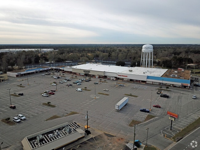
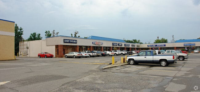
Property Record
7351 Theodore Dawes Rd, Theodore, AL 36582

Property Detail
7351 Theodore Dawes Rd
33-09-31-4-000-086.05
COM AT SW COR OF W 1/2 OF SE 1/4 OF SEC 31 T5S R2W RUN N 00 DEG 04 MIN 45 SEC ALG W/L OF SD W 1/2 OF SE 1/4 OF SD SEC 31 DIS
Storesoffices
MOBILE
B and X Area of moderate flood hazard, usually the area between the limits of the 100-year and 500-year floods.
Alabama
2025
10.64 AC
2025
Outlying Mobile County
006904
Mobile
77,250 SF
Mobile, AL
NEARBY LISTINGS FOR SALE OR LEASE
-
-
View all Theodore listings for lease on LoopNet.com
DEMOGRAPHICS near 7351 Theodore Dawes Rd
1 mile
3 mile
5 mile
2025 Total Population
3,482
22,752
48,926
2030 Population
3,473
22,475
48,342
Pop Growth 2025-2030
(0.26%)
(1.22%)
(1.19%)
Average Age
38
40
40
2025 Total Households
1,412
8,748
18,967
HH Growth 2025-2030
(0.28%)
(1.27%)
(1.20%)
Median Household Inc
$34,616
$55,817
$66,244
Avg Household Size
2.40
2.50
2.50
2025 Avg HH Vehicles
1.00
2.00
2.00
Median Home Value
$140,304
$160,824
$191,150
Median Year Built
1986
1985
1988
Nearby Places
Map Layers
Map Styles
 Street
 Aerial
Transit
 Traffic
 Biking
Places
Listings with unknown addresses are not visible on the map
- Restaurants
- Banks
- Shops
- Fitness
- Groceries
PUBLIC TRANSPORTATION
AIRPORT
Mobile Regional
Drive
Walk
Distance
Mobile Regional
24 min
10.9 mi
Mobile International
Drive
Walk
Distance
Mobile International
17 min
11.7 mi
Freight Ports
Port of Mobile
Drive
Walk
Distance
Port of Mobile
20 min
15.1 mi
SALE & LEASE HISTORY
LISTING DATE
SALE/LEASE

Sep 25, 2016
For Lease
Nearby Properties
Address
Land Use
TOTAL SIZE
Lot Size
Zoning
Address
Land Use
TOTAL SIZE
Lot Size
Zoning
2,503,800 SF
400.86 AC
Address
Land Use
TOTAL SIZE
Lot Size
Zoning
362,880 SF
32.55 AC
Address
Land Use
TOTAL SIZE
Lot Size
Zoning
202,866 SF
8.52 AC
Address
Land Use
TOTAL SIZE
Lot Size
Zoning
155,320 SF
21.48 AC
Address
Land Use
TOTAL SIZE
Lot Size
Zoning
342,598 SF
11.94 AC
Address
Land Use
TOTAL SIZE
Lot Size
Zoning
167,968 SF
12.40 AC
Address
Land Use
TOTAL SIZE
Lot Size
Zoning
86,168 SF
42 AC
Address
Land Use
TOTAL SIZE
Lot Size
Zoning
193,452 SF
17.61 AC
Address
Land Use
TOTAL SIZE
Lot Size
Zoning
12,071 SF
6.87 AC
Address
Land Use
TOTAL SIZE
Lot Size
Zoning
70,838 SF
181.63 AC
Address
Land Use
TOTAL SIZE
Lot Size
Zoning
86,820 SF
4.50 AC
Address
Land Use
TOTAL SIZE
Lot Size
Zoning
58,306 SF
3.11 AC
Address
Land Use
TOTAL SIZE
Lot Size
Zoning
79,503 SF
17.97 AC
Address
Land Use
TOTAL SIZE
Lot Size
Zoning
13,550 SF
14.99 AC
Address
Land Use
TOTAL SIZE
Lot Size
Zoning
73,199 SF
6.90 AC
Address
Land Use
TOTAL SIZE
Lot Size
Zoning
26,460 SF
24.70 AC
Address
Land Use
TOTAL SIZE
Lot Size
Zoning
41,333 SF
6.35 AC
Address
Land Use
TOTAL SIZE
Lot Size
Zoning
107,156 SF
42.22 AC
Address
Land Use
TOTAL SIZE
Lot Size
Zoning
84,497 SF
3.05 AC
Address
Land Use
TOTAL SIZE
Lot Size
Zoning
25,000 SF
10.10 AC
Address
Land Use
TOTAL SIZE
Lot Size
Zoning
66,756 SF
22 AC
Address
Land Use
TOTAL SIZE
Lot Size
Zoning
66,608 SF
6.24 AC
Address
Land Use
TOTAL SIZE
Lot Size
Zoning
29,522 SF
5.32 AC
Address
Land Use
TOTAL SIZE
Lot Size
Zoning
9,900 SF
5.20 AC
Address
Land Use
TOTAL SIZE
Lot Size
Zoning
60,000 SF
6.15 AC
Address
Land Use
TOTAL SIZE
Lot Size
Zoning
12,596 SF
4.30 AC
Address
Land Use
TOTAL SIZE
Lot Size
Zoning
5,357 SF
95 AC
Address
Land Use
TOTAL SIZE
Lot Size
Zoning
8,244 SF
6.67 AC
Address
Land Use
TOTAL SIZE
Lot Size
Zoning
10,244 SF
1.76 AC
The World's #1 Commercial Real Estate Marketplace
Connect with us
© 2026 CoStar Group
The information above has been obtained from sources believed reliable. While we do not doubt its accuracy we have not verified it and make no guarantee, warranty or representation about it. It is your responsibility to independently confirm its accuracy and completeness. Any projections, opinions, assumptions, or estimates used are for example only and do not represent the current or future performance of the property. The value of this transaction to you depends on tax and other factors which should be evaluated by your tax, financial, and legal advisors. You and your advisors should conduct a careful, independent investigation of the property to determine to your satisfaction the suitability of the property for your needs.