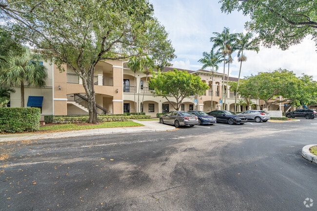
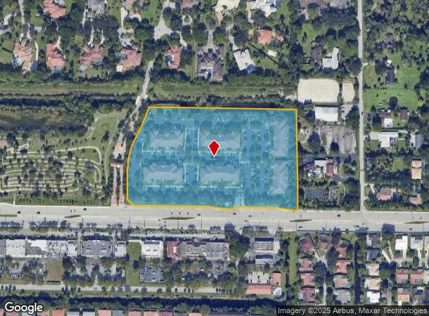
Property Record
7551 Wiles Rd, Coral Springs, FL 33067


Current Lease Availabilities
NEARBY LISTINGS FOR SALE OR LEASE
Property Detail
7551 Wiles Rd
48-41-11-AA-0010
Whispering Woods Center
Officebuilding
WHISPERING WOODS CENTER COMM CONDO UNIT 1-101 BLDG 1 PER AMCDO BK/PG: 44839/895
AE
Broward
12099C1175F
Florida
2024
9.29 AC
2025
NW Broward/Coral Springs
010605
South Florida
1,800 SF
Fort Lauderdale-Pompano Beach-Deerfield Beach, FL
DEMOGRAPHICS near 7551 Wiles Rd
1 Mile
3 Mile
5 Mile
2024 Total Population
13,420
129,276
330,956
2029 Population
13,092
127,134
328,289
Pop Growth 2024-2029
(2.44%)
(1.66%)
(0.81%)
Average Age
37
39
40
2024 Total Households
4,159
46,266
117,658
HH Growth 2024-2029
(3.13%)
(2.23%)
(1.20%)
Median Household Inc
$98,968
$79,563
$74,876
Avg Household Size
3.00
2.70
2.70
2024 Avg HH Vehicles
2.00
2.00
2.00
Median Home Value
$448,008
$380,908
$358,980
Median Year Built
1985
1987
1985
Nearby Places
Map Layers
Map Styles
 Street
 Aerial
- Restaurants
- Banks
- Shops
- Fitness
- Groceries
PUBLIC TRANSPORTATION
AIRPORT
Fort Lauderdale/Hollywood International
DRIVE
WALK
Distance
Fort Lauderdale/Hollywood International
21 min
11.6 mi
Palm Beach International
DRIVE
WALK
Distance
Palm Beach International
40 min
37.1 mi
Nearby Properties
Address
Land Use
TOTAL SIZE
Lot Size
Zoning
Address
Land Use
TOTAL SIZE
Lot Size
Zoning
447,756 SF
45.30 AC
BCRM-5
Address
Land Use
TOTAL SIZE
Lot Size
Zoning
421,779 SF
23.07 AC
PUD
Address
Land Use
TOTAL SIZE
Lot Size
Zoning
457,406 SF
21.26 AC
MC
Address
Land Use
TOTAL SIZE
Lot Size
Zoning
640,399 SF
2.41 AC
Address
Land Use
TOTAL SIZE
Lot Size
Zoning
641,010 SF
29.99 AC
RM-20
Address
Land Use
TOTAL SIZE
Lot Size
Zoning
405,715 SF
20.11 AC
PUD
Address
Land Use
TOTAL SIZE
Lot Size
Zoning
399,296 SF
20.23 AC
RM-40
Address
Land Use
TOTAL SIZE
Lot Size
Zoning
451,337 SF
33.01 AC
R-3A
Address
Land Use
TOTAL SIZE
Lot Size
Zoning
356,704 SF
11.84 AC
PCD
Address
Land Use
TOTAL SIZE
Lot Size
Zoning
294,865 SF
14.49 AC
PUD
Address
Land Use
TOTAL SIZE
Lot Size
Zoning
500,974 SF
16.20 AC
CF-1
Address
Land Use
TOTAL SIZE
Lot Size
Zoning
276,412 SF
10.40 AC
TOC-G
Address
Land Use
TOTAL SIZE
Lot Size
Zoning
390,795 SF
16.83 AC
PUD
Address
Land Use
TOTAL SIZE
Lot Size
Zoning
278,336 SF
15.85 AC
RM-20
Address
Land Use
TOTAL SIZE
Lot Size
Zoning
354,535 SF
33.95 AC
RM-15
Address
Land Use
TOTAL SIZE
Lot Size
Zoning
311,680 SF
15.84 AC
PUD
Address
Land Use
TOTAL SIZE
Lot Size
Zoning
345,189 SF
9.66 AC
RM-30
Address
Land Use
TOTAL SIZE
Lot Size
Zoning
421,001 SF
44.62 AC
CF
Address
Land Use
TOTAL SIZE
Lot Size
Zoning
293,096 SF
11.84 AC
RM-20
Address
Land Use
TOTAL SIZE
Lot Size
Zoning
325,343 SF
21.10 AC
PUD
Address
Land Use
TOTAL SIZE
Lot Size
Zoning
384,131 SF
17.84 AC
PMDD
Address
Land Use
TOTAL SIZE
Lot Size
Zoning
311,836 SF
13.92 AC
RM-30
Address
Land Use
TOTAL SIZE
Lot Size
Zoning
275,724 SF
26.67 AC
TOC-G
Address
Land Use
TOTAL SIZE
Lot Size
Zoning
349,250 SF
19.90 AC
CF
Address
Land Use
TOTAL SIZE
Lot Size
Zoning
269,508 SF
38.46 AC
A-1
Address
Land Use
TOTAL SIZE
Lot Size
Zoning
254,235 SF
25.40 AC
RM-10
Address
Land Use
TOTAL SIZE
Lot Size
Zoning
935,349 SF
20.20 AC
PMDD
Address
Land Use
TOTAL SIZE
Lot Size
Zoning
202,587 SF
11.01 AC
R-3A
Address
Land Use
TOTAL SIZE
Lot Size
Zoning
353,516 SF
33.96 AC
CF-E
Address
Land Use
TOTAL SIZE
Lot Size
Zoning
214,164 SF
11.31 AC
PUD
The World's #1 Commercial Real Estate Marketplace
Connect with us
© 2025 CoStar Group
The information above has been obtained from sources believed reliable. While we do not doubt its accuracy we have not verified it and make no guarantee, warranty or representation about it. It is your responsibility to independently confirm its accuracy and completeness. Any projections, opinions, assumptions, or estimates used are for example only and do not represent the current or future performance of the property. The value of this transaction to you depends on tax and other factors which should be evaluated by your tax, financial, and legal advisors. You and your advisors should conduct a careful, independent investigation of the property to determine to your satisfaction the suitability of the property for your needs.