Property Record
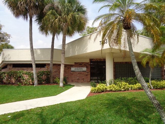
7353 Nw 4Th St, Plantation, FL 33317


NEARBY LISTINGS FOR SALE OR LEASE
Property Detail
7353 Nw 4Th St
50-41-03-50-0010
Rogoff Plat 95-22 B
Officebuilding
ROGOFF PLAT 95-22 B PARCEL 21
AH
Broward
12011C0363J
Florida
2024
0.50 AC
2025
Plantation
060606
South Florida
5,135 SF
Fort Lauderdale-Pompano Beach-Deerfield Beach, FL
DEMOGRAPHICS near 7353 Nw 4Th St
1 Mile
3 Mile
5 Mile
2024 Total Population
14,910
167,491
423,107
2029 Population
15,028
166,920
422,279
Pop Growth 2024-2029
+ 0.79%
(0.34%)
(0.20%)
Average Age
40
40
40
2024 Total Households
5,955
64,536
157,659
HH Growth 2024-2029
+ 0.60%
(0.66%)
(0.44%)
Median Household Inc
$87,947
$57,790
$58,413
Avg Household Size
2.30
2.50
2.60
2024 Avg HH Vehicles
2.00
2.00
2.00
Median Home Value
$328,931
$292,813
$291,400
Median Year Built
1980
1977
1978
Nearby Places
Map Layers
Map Styles
 Street
 Aerial
- Restaurants
- Banks
- Shops
- Fitness
- Groceries
PUBLIC TRANSPORTATION
COMMUTER RAIL
Fort Lauderdale (Tri-County Commuter - South Florida Regional Transportation Authority (Tri-Rail))
DRIVE
WALK
Distance
Fort Lauderdale (Tri-County Commuter - South Florida Regional Transportation Authority (Tri-Rail))
13 min
5.5 mi
Fort Lauderdale/Hollywood International Airport (Tri-County Commuter - South Florida Regional Transportation Authority (Tri-Rail))
DRIVE
WALK
Distance
Fort Lauderdale/Hollywood International Airport (Tri-County Commuter - South Florida Regional Transportation Authority (Tri-Rail))
16 min
9.8 mi
AIRPORT
Fort Lauderdale/Hollywood International
DRIVE
WALK
Distance
Fort Lauderdale/Hollywood International
20 min
10.6 mi
Miami International
DRIVE
WALK
Distance
Miami International
49 min
35.8 mi
Freight Ports
Port Everglades
DRIVE
WALK
Distance
Port Everglades
1 min
7.7 mi
SALE & LEASE HISTORY
LISTING DATE
SALE/LEASE

Mar 14, 2025
For Sale
Dec 07, 2017
For Sale
Nearby Properties
Address
Land Use
TOTAL SIZE
Lot Size
Zoning
Address
Land Use
TOTAL SIZE
Lot Size
Zoning
663,255 SF
3.15 AC
RAC-CC
Address
Land Use
TOTAL SIZE
Lot Size
Zoning
458,854 SF
30.97 AC
PRD-15Q **
Address
Land Use
TOTAL SIZE
Lot Size
Zoning
627,368 SF
4.33 AC
PRD-21Q
Address
Land Use
TOTAL SIZE
Lot Size
Zoning
507,890 SF
39.49 AC
M-PM
Address
Land Use
TOTAL SIZE
Lot Size
Zoning
475,897 SF
14.91 AC
RAC-RTE
Address
Land Use
TOTAL SIZE
Lot Size
Zoning
413,123 SF
63.50 AC
B-3
Address
Land Use
TOTAL SIZE
Lot Size
Zoning
438,123 SF
47.44 AC
RM-22
Address
Land Use
TOTAL SIZE
Lot Size
Zoning
409,340 SF
15.49 AC
RAC-RTE
Address
Land Use
TOTAL SIZE
Lot Size
Zoning
613,363 SF
6.24 AC
B-7Q
Address
Land Use
TOTAL SIZE
Lot Size
Zoning
517,961 SF
3.92 AC
M-PM
Address
Land Use
TOTAL SIZE
Lot Size
Zoning
497,004 SF
4.46 AC
M-PM
Address
Land Use
TOTAL SIZE
Lot Size
Zoning
524,015 SF
6.43 AC
B-7Q
Address
Land Use
TOTAL SIZE
Lot Size
Zoning
471,109 SF
5.57 AC
M-PM
Address
Land Use
TOTAL SIZE
Lot Size
Zoning
527,086 SF
2.34 AC
M-PM
Address
Land Use
TOTAL SIZE
Lot Size
Zoning
346,662 SF
26.47 AC
RM-18
Address
Land Use
TOTAL SIZE
Lot Size
Zoning
320,919 SF
27.70 AC
M-PM
Address
Land Use
TOTAL SIZE
Lot Size
Zoning
439,908 SF
13.54 AC
OP-P
Address
Land Use
TOTAL SIZE
Lot Size
Zoning
256,568 SF
22.61 AC
PRD-12.15Q
Address
Land Use
TOTAL SIZE
Lot Size
Zoning
312,067 SF
20.94 AC
PRD-15Q
Address
Land Use
TOTAL SIZE
Lot Size
Zoning
289,523 SF
9.44 AC
B-HCS
Address
Land Use
TOTAL SIZE
Lot Size
Zoning
321,240 SF
2.16 AC
M-PM
Address
Land Use
TOTAL SIZE
Lot Size
Zoning
296,166 SF
18.40 AC
RM-18
Address
Land Use
TOTAL SIZE
Lot Size
Zoning
277,664 SF
21.35 AC
PRD-12.15Q
Address
Land Use
TOTAL SIZE
Lot Size
Zoning
445,798 SF
11.80 AC
OP-P
Address
Land Use
TOTAL SIZE
Lot Size
Zoning
300,359 SF
11.76 AC
PRD-15.7Q
Address
Land Use
TOTAL SIZE
Lot Size
Zoning
234,496 SF
3.07 AC
M-PM
Address
Land Use
TOTAL SIZE
Lot Size
Zoning
231,498 SF
19.56 AC
PRD-12.15Q
Address
Land Use
TOTAL SIZE
Lot Size
Zoning
157,841 SF
3.03 AC
I-L2P
Address
Land Use
TOTAL SIZE
Lot Size
Zoning
405,695 SF
10.08 AC
M-PM
Address
Land Use
TOTAL SIZE
Lot Size
Zoning
248,539 SF
0.13 AC
M-PM
The World's #1 Commercial Real Estate Marketplace
Connect with us
© 2026 CoStar Group
The information above has been obtained from sources believed reliable. While we do not doubt its accuracy we have not verified it and make no guarantee, warranty or representation about it. It is your responsibility to independently confirm its accuracy and completeness. Any projections, opinions, assumptions, or estimates used are for example only and do not represent the current or future performance of the property. The value of this transaction to you depends on tax and other factors which should be evaluated by your tax, financial, and legal advisors. You and your advisors should conduct a careful, independent investigation of the property to determine to your satisfaction the suitability of the property for your needs.