Property Record
7359 Thomaston Rd, Macon, GA 31220
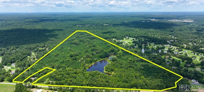

This Property Is For Sale
Property Detail
7359 Thomaston Rd
Warehouse
BIBB
A
Georgia
A Areas with a 1% annual chance of flooding and a 26% chance of flooding over the life of a 30-year mortgage.
158.97 AC
2025
Outlying Bibb County
2025
Atlanta
013605
Macon-Bibb County, GA
1,452 SF
G006-0004
NEARBY LISTINGS FOR SALE OR LEASE
DEMOGRAPHICS near 7359 Thomaston Rd
1 mile
3 mile
5 mile
2025 Total Population
952
14,044
29,576
2030 Population
942
13,937
29,582
Pop Growth 2025-2030
(1.05%)
(0.76%)
+ 0.02%
Average Age
43
41
42
2025 Total Households
383
5,554
11,831
HH Growth 2025-2030
(1.04%)
(0.67%)
+ 0.02%
Median Household Inc
$91,216
$85,525
$94,068
Avg Household Size
2.40
2.50
2.40
2025 Avg HH Vehicles
2.00
2.00
2.00
Median Home Value
$252,272
$260,821
$289,070
Median Year Built
1993
1995
1994
Nearby Places
Map Layers
Map Styles
 Street
 Aerial
Layers
 Traffic
 Biking
Places
Listings with unknown addresses are not visible on the map
- Restaurants
- Banks
- Shops
- Fitness
- Groceries
Nearby Properties
Address
Land Use
TOTAL SIZE
Lot Size
Zoning
Address
Land Use
TOTAL SIZE
Lot Size
Zoning
22,421 SF
13.60 AC
PDE
Address
Land Use
TOTAL SIZE
Lot Size
Zoning
98,912 SF
13.95 AC
PDE
Address
Land Use
TOTAL SIZE
Lot Size
Zoning
59,801 SF
28.03 AC
PDE
Address
Land Use
TOTAL SIZE
Lot Size
Zoning
5,270 SF
20 AC
Address
Land Use
TOTAL SIZE
Lot Size
Zoning
214,685 SF
18.69 AC
C-2
Address
Land Use
TOTAL SIZE
Lot Size
Zoning
20,544 SF
62.02 AC
A
Address
Land Use
TOTAL SIZE
Lot Size
Zoning
2,070 SF
24.17 AC
PDR
Address
Land Use
TOTAL SIZE
Lot Size
Zoning
3,025 SF
23.37 AC
R-3
Address
Land Use
TOTAL SIZE
Lot Size
Zoning
211,781 SF
22.45 AC
PDE
Address
Land Use
TOTAL SIZE
Lot Size
Zoning
29,277 SF
15.01 AC
PDE
Address
Land Use
TOTAL SIZE
Lot Size
Zoning
2,854 SF
14.08 AC
PDR
Address
Land Use
TOTAL SIZE
Lot Size
Zoning
135,820 SF
20 AC
PDE
Address
Land Use
TOTAL SIZE
Lot Size
Zoning
10,500 SF
11.21 AC
PDE
Address
Land Use
TOTAL SIZE
Lot Size
Zoning
67,883 SF
9.11 AC
PDE
Address
Land Use
TOTAL SIZE
Lot Size
Zoning
88,509 SF
10.61 AC
PDE
Address
Land Use
TOTAL SIZE
Lot Size
Zoning
62,676 SF
8.57 AC
PDE
Address
Land Use
TOTAL SIZE
Lot Size
Zoning
76,091 SF
36.14 AC
A
Address
Land Use
TOTAL SIZE
Lot Size
Zoning
54,465 SF
3.52 AC
PDE
Address
Land Use
TOTAL SIZE
Lot Size
Zoning
45,807 SF
6.50 AC
PDR
Address
Land Use
TOTAL SIZE
Lot Size
Zoning
15,040 SF
7.88 AC
PDE
Address
Land Use
TOTAL SIZE
Lot Size
Zoning
5,312 SF
10 AC
PDE
Address
Land Use
TOTAL SIZE
Lot Size
Zoning
66,528 SF
11.41 AC
PDR
Address
Land Use
TOTAL SIZE
Lot Size
Zoning
38,030 SF
5.27 AC
PDE
Address
Land Use
TOTAL SIZE
Lot Size
Zoning
18,532 SF
5.04 AC
PDR
Address
Land Use
TOTAL SIZE
Lot Size
Zoning
49,908 SF
3.05 AC
PDE
Address
Land Use
TOTAL SIZE
Lot Size
Zoning
63.99 AC
PDE
Address
Land Use
TOTAL SIZE
Lot Size
Zoning
35,437 SF
2.08 AC
PDE
Address
Land Use
TOTAL SIZE
Lot Size
Zoning
26,600 SF
7 AC
PDE
Address
Land Use
TOTAL SIZE
Lot Size
Zoning
31,676 SF
8 AC
PDE
Address
Land Use
TOTAL SIZE
Lot Size
Zoning
38,400 SF
3.42 AC
PDE
The World's #1 Commercial Real Estate Marketplace
Connect with us
© 2026 CoStar Group
The information above has been obtained from sources believed reliable. While we do not doubt its accuracy we have not verified it and make no guarantee, warranty or representation about it. It is your responsibility to independently confirm its accuracy and completeness. Any projections, opinions, assumptions, or estimates used are for example only and do not represent the current or future performance of the property. The value of this transaction to you depends on tax and other factors which should be evaluated by your tax, financial, and legal advisors. You and your advisors should conduct a careful, independent investigation of the property to determine to your satisfaction the suitability of the property for your needs.