Property Record
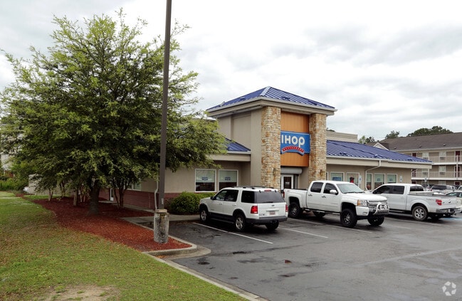
7361 Mazyck Rd, Charleston, SC 29406


NEARBY LISTINGS FOR SALE OR LEASE
Property Detail
7361 Mazyck Rd
478-02-00-078
Sanders
Restaurantbuilding
DESCRIPTION -TRACT B SUBDIVISION NAME -SANDERS SITE NAME -IHOP SUBDIVISION NAME -SANDERS DESCRIPTION -TRACT B
X
Charleston
45019C0295K
South Carolina
2025
0.99 AC
2024
North Charleston
003104
Charleston/N Charleston
5,009 SF
Charleston-North Charleston, SC
DEMOGRAPHICS near 7361 Mazyck Rd
1 Mile
3 Mile
5 Mile
2024 Total Population
7,331
56,823
145,984
2029 Population
7,721
62,283
161,047
Pop Growth 2024-2029
+ 5.32%
+ 9.61%
+ 10.32%
Average Age
35
36
37
2024 Total Households
2,845
22,067
56,224
HH Growth 2024-2029
+ 5.10%
+ 9.43%
+ 10.13%
Median Household Inc
$35,029
$58,166
$61,116
Avg Household Size
2.50
2.50
2.50
2024 Avg HH Vehicles
1.00
2.00
2.00
Median Home Value
$165,870
$229,536
$232,138
Median Year Built
1983
1990
1992
Nearby Places
Map Layers
Map Styles
 Street
 Aerial
- Restaurants
- Banks
- Shops
- Fitness
- Groceries
PUBLIC TRANSPORTATION
COMMUTER RAIL
Charleston Amtrak Station (Palmetto - Amtrak, Silver Meteor - Amtrak)
DRIVE
WALK
Distance
Charleston Amtrak Station (Palmetto - Amtrak, Silver Meteor - Amtrak)
11 min
6.3 mi
AIRPORT
Charleston AFB/International
DRIVE
WALK
Distance
Charleston AFB/International
15 min
4.7 mi
Freight Ports
North Charleston Terminal
DRIVE
WALK
Distance
North Charleston Terminal
11 min
6.0 mi
SALE & LEASE HISTORY
LISTING DATE
SALE/LEASE

Mar 04, 2022
For Sale
Nearby Properties
Address
Land Use
TOTAL SIZE
Lot Size
Zoning
Address
Land Use
TOTAL SIZE
Lot Size
Zoning
313,920 SF
23.09 AC
HANAHAN -
Address
Land Use
TOTAL SIZE
Lot Size
Zoning
2,917 SF
11.76 AC
HANAHAN -
Address
Land Use
TOTAL SIZE
Lot Size
Zoning
247,000 SF
19.55 AC
HANAHAN -
Address
Land Use
TOTAL SIZE
Lot Size
Zoning
Address
Land Use
TOTAL SIZE
Lot Size
Zoning
10,172 SF
12.76 AC
Address
Land Use
TOTAL SIZE
Lot Size
Zoning
7,200 SF
8.73 AC
Address
Land Use
TOTAL SIZE
Lot Size
Zoning
302,400 SF
18.71 AC
HANAHAN -
Address
Land Use
TOTAL SIZE
Lot Size
Zoning
302,400 SF
23.70 AC
HANAHAN -
Address
Land Use
TOTAL SIZE
Lot Size
Zoning
350,760 SF
25.65 AC
HANAHAN -
Address
Land Use
TOTAL SIZE
Lot Size
Zoning
64,584 SF
10.92 AC
HANAHAN -
Address
Land Use
TOTAL SIZE
Lot Size
Zoning
137,576 SF
5 AC
HANAHAN -
Address
Land Use
TOTAL SIZE
Lot Size
Zoning
4,320 SF
8.14 AC
HANAHAN -
Address
Land Use
TOTAL SIZE
Lot Size
Zoning
36,882 SF
5.80 AC
HANAHAN -
Address
Land Use
TOTAL SIZE
Lot Size
Zoning
390,180 SF
20.76 AC
HANAHAN -
Address
Land Use
TOTAL SIZE
Lot Size
Zoning
36,912 SF
6.19 AC
HANAHAN -
Address
Land Use
TOTAL SIZE
Lot Size
Zoning
123,750 SF
10.12 AC
HANAHAN -
Address
Land Use
TOTAL SIZE
Lot Size
Zoning
21,364 SF
7.71 AC
Address
Land Use
TOTAL SIZE
Lot Size
Zoning
92,800 SF
15.24 AC
HANAHAN -
Address
Land Use
TOTAL SIZE
Lot Size
Zoning
7,176 SF
3.55 AC
HANAHAN -
Address
Land Use
TOTAL SIZE
Lot Size
Zoning
101,011 SF
6.58 AC
Address
Land Use
TOTAL SIZE
Lot Size
Zoning
54,449 SF
10.56 AC
HANAHAN -
Address
Land Use
TOTAL SIZE
Lot Size
Zoning
199,300 SF
13.28 AC
Address
Land Use
TOTAL SIZE
Lot Size
Zoning
48,885 SF
5.02 AC
Address
Land Use
TOTAL SIZE
Lot Size
Zoning
126,385 SF
13.45 AC
Address
Land Use
TOTAL SIZE
Lot Size
Zoning
14,725 SF
3.55 AC
Address
Land Use
TOTAL SIZE
Lot Size
Zoning
Address
Land Use
TOTAL SIZE
Lot Size
Zoning
133.75 AC
MUC_DC
Address
Land Use
TOTAL SIZE
Lot Size
Zoning
14,775 SF
1.52 AC
HANAHAN -
Address
Land Use
TOTAL SIZE
Lot Size
Zoning
48,400 SF
5.76 AC
Address
Land Use
TOTAL SIZE
Lot Size
Zoning
167,100 SF
8 AC
The World's #1 Commercial Real Estate Marketplace
Connect with us
© 2025 CoStar Group
The information above has been obtained from sources believed reliable. While we do not doubt its accuracy we have not verified it and make no guarantee, warranty or representation about it. It is your responsibility to independently confirm its accuracy and completeness. Any projections, opinions, assumptions, or estimates used are for example only and do not represent the current or future performance of the property. The value of this transaction to you depends on tax and other factors which should be evaluated by your tax, financial, and legal advisors. You and your advisors should conduct a careful, independent investigation of the property to determine to your satisfaction the suitability of the property for your needs.