Property Record
7364 Main St, Greenville, NC 27834

Save to a Folder
{{folder.Name}}
{{folder.ListingIds.length}} Properties
{{folder.ListingIds.length}} Property
Create a New Folder
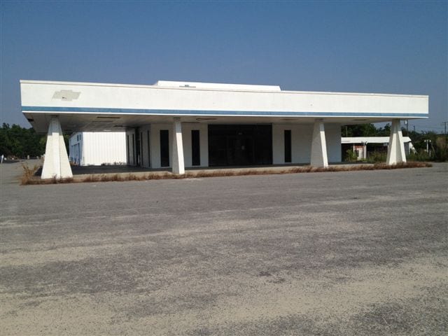
Property Detail
7364 Main St
013417
CEDAR RUN CAPITAL LLC
Commercialnec
PITT
CB
North Carolina
B and X Area of moderate flood hazard, usually the area between the limits of the 100-year and 500-year floods.
1.41 AC
2025
North Carolina Northeast Area
2025
Other Market Areas
9,180 SF
Greenville, NC
NEARBY LISTINGS FOR SALE OR LEASE
-
-
View all Greenville listings for sale on LoopNet.com
DEMOGRAPHICS near 7364 Main St
1 mile
3 mile
5 mile
2025 Total Population
828
1,326
2,212
2030 Population
776
1,252
2,125
Pop Growth 2025-2030
(6.28%)
(5.58%)
(3.93%)
Average Age
43
43
43
2025 Total Households
353
562
931
HH Growth 2025-2030
(6.80%)
(5.87%)
(4.30%)
Median Household Inc
$54,270
$53,466
$53,778
Avg Household Size
2.40
2.40
2.40
2025 Avg HH Vehicles
2.00
2.00
2.00
Median Home Value
$155,555
$149,479
$149,397
Median Year Built
1967
1968
1971
Nearby Places
Map Layers
Map Styles
 Street
 Aerial
Layers
 Traffic
 Biking
Places
Listings with unknown addresses are not visible on the map
- Restaurants
- Banks
- Shops
- Fitness
- Groceries
PUBLIC TRANSPORTATION
AIRPORT
Pitt-Greenville
Drive
Walk
Distance
Pitt-Greenville
19 min
13.7 mi
Freight Ports
Port of Morehead City
Drive
Walk
Distance
Port of Morehead City
146 min
103.0 mi
SALE & LEASE HISTORY
LISTING DATE
SALE/LEASE

Sep 24, 2016
For Sale
Oct 06, 2016
For Sale
Mar 24, 2017
For Sale
Nearby Properties
Address
Land Use
TOTAL SIZE
Lot Size
Zoning
Address
Land Use
TOTAL SIZE
Lot Size
Zoning
76,368 SF
4.38 AC
HB
Address
Land Use
TOTAL SIZE
Lot Size
Zoning
90,426 SF
5.33 AC
NB
Address
Land Use
TOTAL SIZE
Lot Size
Zoning
97,630 SF
48.64 AC
RR
Address
Land Use
TOTAL SIZE
Lot Size
Zoning
242.50 AC
RA20
Address
Land Use
TOTAL SIZE
Lot Size
Zoning
380 SF
5.04 AC
R6
Address
Land Use
TOTAL SIZE
Lot Size
Zoning
15,337 SF
1.37 AC
CB
Address
Land Use
TOTAL SIZE
Lot Size
Zoning
7,704 SF
3 AC
MHZ
Address
Land Use
TOTAL SIZE
Lot Size
Zoning
6,534 SF
4.34 AC
NB
Address
Land Use
TOTAL SIZE
Lot Size
Zoning
15,776 SF
1.03 AC
CB
Address
Land Use
TOTAL SIZE
Lot Size
Zoning
9,226 SF
0.90 AC
R15
Address
Land Use
TOTAL SIZE
Lot Size
Zoning
3,597 SF
9.54 AC
I
Address
Land Use
TOTAL SIZE
Lot Size
Zoning
372.27 AC
Address
Land Use
TOTAL SIZE
Lot Size
Zoning
2,011 SF
179.99 AC
RA
Address
Land Use
TOTAL SIZE
Lot Size
Zoning
14.68 AC
RA20
Address
Land Use
TOTAL SIZE
Lot Size
Zoning
27,639 SF
2.15 AC
HB
Address
Land Use
TOTAL SIZE
Lot Size
Zoning
185.20 AC
Address
Land Use
TOTAL SIZE
Lot Size
Zoning
8,125 SF
1.02 AC
NB
Address
Land Use
TOTAL SIZE
Lot Size
Zoning
142.22 AC
RA
Address
Land Use
TOTAL SIZE
Lot Size
Zoning
127.53 AC
RA20
Address
Land Use
TOTAL SIZE
Lot Size
Zoning
1,776 SF
220.40 AC
Address
Land Use
TOTAL SIZE
Lot Size
Zoning
5,424 SF
2.47 AC
MFR
Address
Land Use
TOTAL SIZE
Lot Size
Zoning
8,700 SF
2.08 AC
NB
Address
Land Use
TOTAL SIZE
Lot Size
Zoning
226.69 AC
I
Address
Land Use
TOTAL SIZE
Lot Size
Zoning
13.95 AC
RA20
Address
Land Use
TOTAL SIZE
Lot Size
Zoning
257.85 AC
RA
Address
Land Use
TOTAL SIZE
Lot Size
Zoning
164 AC
Address
Land Use
TOTAL SIZE
Lot Size
Zoning
171.44 AC
RA20
Address
Land Use
TOTAL SIZE
Lot Size
Zoning
74.74 AC
RA20
Address
Land Use
TOTAL SIZE
Lot Size
Zoning
20,405 SF
5.16 AC
I
The World's #1 Commercial Real Estate Marketplace
Connect with us
© 2026 CoStar Group
The information above has been obtained from sources believed reliable. While we do not doubt its accuracy we have not verified it and make no guarantee, warranty or representation about it. It is your responsibility to independently confirm its accuracy and completeness. Any projections, opinions, assumptions, or estimates used are for example only and do not represent the current or future performance of the property. The value of this transaction to you depends on tax and other factors which should be evaluated by your tax, financial, and legal advisors. You and your advisors should conduct a careful, independent investigation of the property to determine to your satisfaction the suitability of the property for your needs.