Property Record
7365 Up River Rd, Corpus Christi, TX 78409
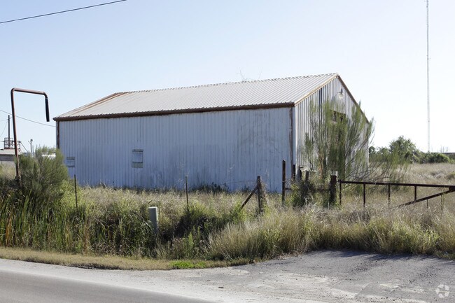

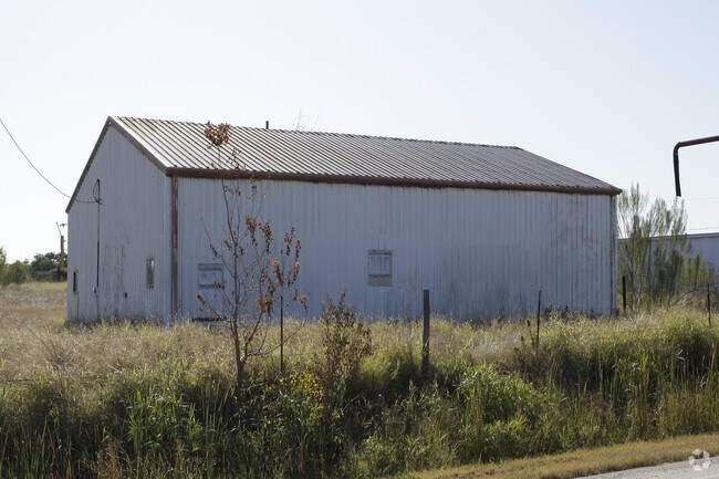
Property Detail
7365 Up River Rd
Corpus Christi, TX
KINNEY SECTIONIZED LANDS 35.99 ACS OUT OF LT 1 BLK A
250698
NUECES
Industrialgeneral
Texas
AE The base floodplain where base flood elevations are provided. AE Zones are now used on new format FIRMs instead of A1-A30 Zones.
1
2024
35.99 AC
2025
Northwest
003500
Corpus Christi
29,400 SF
NEARBY LISTINGS FOR SALE OR LEASE
DEMOGRAPHICS near 7365 Up River Rd
1 mile
3 mile
5 mile
2025 Total Population
409
8,915
25,748
2030 Population
407
8,925
25,660
Pop Growth 2025-2030
(0.49%)
+ 0.11%
(0.34%)
Average Age
39
38
38
2025 Total Households
144
3,231
9,172
HH Growth 2025-2030
(0.69%)
(0.15%)
(0.59%)
Median Household Inc
$72,655
$58,753
$58,217
Avg Household Size
2.80
2.70
2.70
2025 Avg HH Vehicles
2.00
2.00
2.00
Median Home Value
$153,124
$129,700
$155,703
Median Year Built
1977
1986
1981
Nearby Places
Map Layers
Map Styles
 Street
 Aerial
Layers
 Traffic
 Biking
Places
Listings with unknown addresses are not visible on the map
- Restaurants
- Banks
- Shops
- Fitness
- Groceries
PUBLIC TRANSPORTATION
AIRPORT
Corpus Christi International
Drive
Walk
Distance
Corpus Christi International
13 min
7.1 mi
Freight Ports
Port of Corpus Christi
Drive
Walk
Distance
Port of Corpus Christi
11 min
7.8 mi
Nearby Properties
Address
Land Use
TOTAL SIZE
Lot Size
Zoning
Address
Land Use
TOTAL SIZE
Lot Size
Zoning
174,650 SF
1.95 AC
I3
Address
Land Use
TOTAL SIZE
Lot Size
Zoning
233,436 SF
Address
Land Use
TOTAL SIZE
Lot Size
Zoning
126,708 SF
18.17 AC
R1B
Address
Land Use
TOTAL SIZE
Lot Size
Zoning
368.71 AC
OCL
Address
Land Use
TOTAL SIZE
Lot Size
Zoning
67,009 SF
6.99 AC
R1B
Address
Land Use
TOTAL SIZE
Lot Size
Zoning
600.26 AC
Address
Land Use
TOTAL SIZE
Lot Size
Zoning
Address
Land Use
TOTAL SIZE
Lot Size
Zoning
72.29 AC
OCL
Address
Land Use
TOTAL SIZE
Lot Size
Zoning
234.07 AC
OCL
Address
Land Use
TOTAL SIZE
Lot Size
Zoning
141,800 SF
6 AC
Address
Land Use
TOTAL SIZE
Lot Size
Zoning
139.72 AC
OCL
Address
Land Use
TOTAL SIZE
Lot Size
Zoning
50.32 AC
OCL
Address
Land Use
TOTAL SIZE
Lot Size
Zoning
71,839 SF
30.18 AC
Address
Land Use
TOTAL SIZE
Lot Size
Zoning
26,200 SF
4.86 AC
I-2
Address
Land Use
TOTAL SIZE
Lot Size
Zoning
151,918 SF
10 AC
I-3
Address
Land Use
TOTAL SIZE
Lot Size
Zoning
108,360 SF
8.12 AC
B4
Address
Land Use
TOTAL SIZE
Lot Size
Zoning
119.40 AC
OCL
Address
Land Use
TOTAL SIZE
Lot Size
Zoning
20,744 SF
23.64 AC
Address
Land Use
TOTAL SIZE
Lot Size
Zoning
56,431 SF
21.27 AC
Address
Land Use
TOTAL SIZE
Lot Size
Zoning
50,348 SF
11.17 AC
Address
Land Use
TOTAL SIZE
Lot Size
Zoning
96.23 AC
OCL
Address
Land Use
TOTAL SIZE
Lot Size
Zoning
167.06 AC
Address
Land Use
TOTAL SIZE
Lot Size
Zoning
66,052 SF
23.95 AC
I2SP08
Address
Land Use
TOTAL SIZE
Lot Size
Zoning
7,400 SF
43.16 AC
OCL
Address
Land Use
TOTAL SIZE
Lot Size
Zoning
52,096 SF
1.88 AC
B-4
Address
Land Use
TOTAL SIZE
Lot Size
Zoning
36.26 AC
OCL
Address
Land Use
TOTAL SIZE
Lot Size
Zoning
81.50 AC
OCL
Address
Land Use
TOTAL SIZE
Lot Size
Zoning
39,858 SF
29 AC
Address
Land Use
TOTAL SIZE
Lot Size
Zoning
76.13 AC
OCL
The World's #1 Commercial Real Estate Marketplace
Connect with us
© 2026 CoStar Group
The information above has been obtained from sources believed reliable. While we do not doubt its accuracy we have not verified it and make no guarantee, warranty or representation about it. It is your responsibility to independently confirm its accuracy and completeness. Any projections, opinions, assumptions, or estimates used are for example only and do not represent the current or future performance of the property. The value of this transaction to you depends on tax and other factors which should be evaluated by your tax, financial, and legal advisors. You and your advisors should conduct a careful, independent investigation of the property to determine to your satisfaction the suitability of the property for your needs.