Property Record
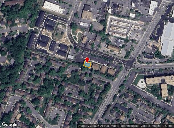
7369 Mcwhorter Pl, Annandale, VA 22003
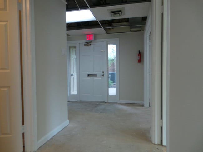
This Property Is For Sale
NEARBY LISTINGS FOR SALE OR LEASE
Property Detail
7369 Mcwhorter Pl
Washington-Arlington-Alexandria, DC-VA-MD-WV
Merrison Square Office Condo
0711-36-0400
MERRISON SQUARE OFFICE CONDO UN 400
Officecondo
Fairfax
X
Virginia
5100540050D
400
2024
0.08 AC
2025
Annandale
452200
Washington, DC
1,082 SF
DEMOGRAPHICS near 7369 Mcwhorter Pl
1 Mile
3 Mile
5 Mile
2024 Total Population
22,386
119,951
437,792
2029 Population
22,077
118,092
431,424
Pop Growth 2024-2029
(1.38%)
(1.55%)
(1.45%)
Average Age
39
40
39
2024 Total Households
7,224
39,281
161,338
HH Growth 2024-2029
(1.55%)
(1.71%)
(1.57%)
Median Household Inc
$90,066
$123,754
$114,865
Avg Household Size
2.90
2.90
2.60
2024 Avg HH Vehicles
2.00
2.00
2.00
Median Home Value
$573,266
$662,008
$646,286
Median Year Built
1968
1966
1973
Nearby Places
Map Layers
Map Styles
 Street
 Aerial
- Restaurants
- Banks
- Shops
- Fitness
- Groceries
PUBLIC TRANSPORTATION
COMMUTER RAIL
Backlick Road (Manassas Line - Virginia Railway Express)
DRIVE
WALK
Distance
Backlick Road (Manassas Line - Virginia Railway Express)
7 min
2.9 mi
Rolling Road (Manassas Line - Virginia Railway Express)
DRIVE
WALK
Distance
Rolling Road (Manassas Line - Virginia Railway Express)
11 min
5.6 mi
AIRPORT
Ronald Reagan Washington Ntl
DRIVE
WALK
Distance
Ronald Reagan Washington Ntl
19 min
10.5 mi
Washington Dulles International
DRIVE
WALK
Distance
Washington Dulles International
37 min
22.8 mi
Freight Ports
Port of Baltimore
DRIVE
WALK
Distance
Port of Baltimore
74 min
54.5 mi
Nearby Properties
Address
Land Use
TOTAL SIZE
Lot Size
Zoning
Address
Land Use
TOTAL SIZE
Lot Size
Zoning
1,434,346 SF
29.59 AC
430
Address
Land Use
TOTAL SIZE
Lot Size
Zoning
829,629 SF
21.30 AC
430
Address
Land Use
TOTAL SIZE
Lot Size
Zoning
1,464,969 SF
39.52 AC
403
Address
Land Use
TOTAL SIZE
Lot Size
Zoning
613,844 SF
499
Address
Land Use
TOTAL SIZE
Lot Size
Zoning
1,031,040 SF
36.16 AC
220
Address
Land Use
TOTAL SIZE
Lot Size
Zoning
429,735 SF
20 AC
560
Address
Land Use
TOTAL SIZE
Lot Size
Zoning
440,979 SF
20 AC
530
Address
Land Use
TOTAL SIZE
Lot Size
Zoning
431,097 SF
16.45 AC
220
Address
Land Use
TOTAL SIZE
Lot Size
Zoning
452,682 SF
20.74 AC
220
Address
Land Use
TOTAL SIZE
Lot Size
Zoning
415,368 SF
21.06 AC
220
Address
Land Use
TOTAL SIZE
Lot Size
Zoning
401,218 SF
13.78 AC
403
Address
Land Use
TOTAL SIZE
Lot Size
Zoning
358,898 SF
6.44 AC
403
Address
Land Use
TOTAL SIZE
Lot Size
Zoning
485,499 SF
19.11 AC
220
Address
Land Use
TOTAL SIZE
Lot Size
Zoning
12.46 AC
220
Address
Land Use
TOTAL SIZE
Lot Size
Zoning
14.97 AC
220
Address
Land Use
TOTAL SIZE
Lot Size
Zoning
264,495 SF
15.55 AC
403
Address
Land Use
TOTAL SIZE
Lot Size
Zoning
461,369 SF
11.10 AC
403
Address
Land Use
TOTAL SIZE
Lot Size
Zoning
253,647 SF
5.99 AC
220
Address
Land Use
TOTAL SIZE
Lot Size
Zoning
308,062 SF
5.15 AC
403
Address
Land Use
TOTAL SIZE
Lot Size
Zoning
726,520 SF
12.37 AC
220
Address
Land Use
TOTAL SIZE
Lot Size
Zoning
339,028 SF
75.81 AC
120
Address
Land Use
TOTAL SIZE
Lot Size
Zoning
Address
Land Use
TOTAL SIZE
Lot Size
Zoning
398,419 SF
18.54 AC
560
Address
Land Use
TOTAL SIZE
Lot Size
Zoning
124,351 SF
14.60 AC
460
Address
Land Use
TOTAL SIZE
Lot Size
Zoning
153,341 SF
11.96 AC
460
Address
Land Use
TOTAL SIZE
Lot Size
Zoning
253,648 SF
10.72 AC
550
Address
Land Use
TOTAL SIZE
Lot Size
Zoning
139,582 SF
10.14 AC
400
Address
Land Use
TOTAL SIZE
Lot Size
Zoning
272,340 SF
7.70 AC
403
Address
Land Use
TOTAL SIZE
Lot Size
Zoning
311,342 SF
4.24 AC
496
Address
Land Use
TOTAL SIZE
Lot Size
Zoning
197,000 SF
4.86 AC
430
The World's #1 Commercial Real Estate Marketplace
Connect with us
© 2025 CoStar Group
The information above has been obtained from sources believed reliable. While we do not doubt its accuracy we have not verified it and make no guarantee, warranty or representation about it. It is your responsibility to independently confirm its accuracy and completeness. Any projections, opinions, assumptions, or estimates used are for example only and do not represent the current or future performance of the property. The value of this transaction to you depends on tax and other factors which should be evaluated by your tax, financial, and legal advisors. You and your advisors should conduct a careful, independent investigation of the property to determine to your satisfaction the suitability of the property for your needs.