Property Record
737 2Nd St, Oakland, CA 94607
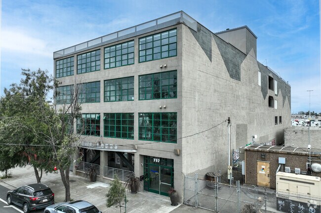


Property Detail
737 2Nd St
Oakland-Fremont-Berkeley, CA
TR: 7168 LOT: BLDG: UNIT:101
001-0117-008-00
ALAMEDA
Commercialcondominium
California
C and X Area of minimal flood hazard, usually depicted on FIRMs as above the 500-year flood level.
1
2024
0.40 AC
2025
Jack London Square
982000
East Bay/Oakland
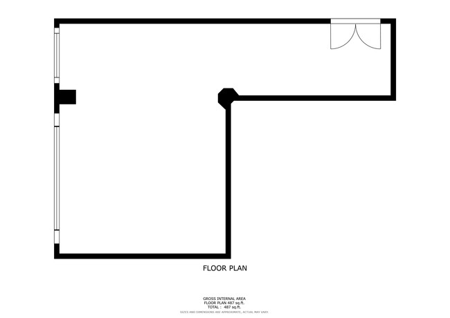
3,441 SF
NEARBY LISTINGS FOR SALE OR LEASE
DEMOGRAPHICS near 737 2Nd St
1 mile
3 mile
5 mile
2025 Total Population
31,474
221,754
463,888
2030 Population
32,318
223,964
465,305
Pop Growth 2025-2030
+ 2.68%
+ 1.00%
+ 0.31%
Average Age
42
41
41
2025 Total Households
14,254
97,801
189,213
HH Growth 2025-2030
+ 2.88%
+ 1.10%
+ 0.40%
Median Household Inc
$78,332
$99,562
$103,667
Avg Household Size
2.00
2.10
2.30
2025 Avg HH Vehicles
1.00
1.00
1.00
Median Home Value
$818,181
$958,557
$1,042,084
Median Year Built
1992
1962
1956
Nearby Places
Map Layers
Map Styles
 Street
 Aerial
Layers
 Traffic
 Biking
Places
Listings with unknown addresses are not visible on the map
- Restaurants
- Banks
- Shops
- Fitness
- Groceries
PUBLIC TRANSPORTATION
TRANSIT/SUBWAY
12Th Street / Oakland City Center (Antioch to SFIA/Millbrae - Bay Area Rapid Transit (BART), Berryessa/North San Jose to Richmond - Bay Area Rapid Transit (BART), Millbrae/SFIA to Antioch - Bay Area Rapid Transit (BART), Millbrae/SFO to Richmond - Bay Area Rapid Transit (BART), Richmond to SFO/Millbrae - Bay Area Rapid Transit (BART))
Drive
Walk
Distance
12Th Street / Oakland City Center (Antioch to SFIA/Millbrae - Bay Area Rapid Transit (BART), Berryessa/North San Jose to Richmond - Bay Area Rapid Transit (BART), Millbrae/SFIA to Antioch - Bay Area Rapid Transit (BART), Millbrae/SFO to Richmond - Bay Area Rapid Transit (BART), Richmond to SFO/Millbrae - Bay Area Rapid Transit (BART))
2 min
18 min
0.9 mi
West Oakland (Antioch to SFIA/Millbrae - Bay Area Rapid Transit (BART), Berryessa/North San Jose to Daly City - Bay Area Rapid Transit (BART), Daly City to Berryessa/North San Jose - Bay Area Rapid Transit (BART), Millbrae/SFIA to Antioch - Bay Area Rapid Transit (BART), Millbrae/SFO to Richmond - Bay Area Rapid Transit (BART))
Drive
Walk
Distance
West Oakland (Antioch to SFIA/Millbrae - Bay Area Rapid Transit (BART), Berryessa/North San Jose to Daly City - Bay Area Rapid Transit (BART), Daly City to Berryessa/North San Jose - Bay Area Rapid Transit (BART), Millbrae/SFIA to Antioch - Bay Area Rapid Transit (BART), Millbrae/SFO to Richmond - Bay Area Rapid Transit (BART))
3 min
18 min
1.0 mi
COMMUTER RAIL
Oakland (Capitol Corridor - Amtrak, Coast Starlight - Amtrak, San Joaquins - Amtrak)
Drive
Walk
Distance
Oakland (Capitol Corridor - Amtrak, Coast Starlight - Amtrak, San Joaquins - Amtrak)
2 min
13 min
0.7 mi
Emeryville (Capitol Corridor - Capitol Corridor Joint Powers Authority)
Drive
Walk
Distance
Emeryville (Capitol Corridor - Capitol Corridor Joint Powers Authority)
9 min
4.7 mi
AIRPORT
Metro Oakland International
Drive
Walk
Distance
Metro Oakland International
15 min
9.4 mi
San Francisco International
Drive
Walk
Distance
San Francisco International
35 min
22.9 mi
Freight Ports
Port of Oakland
Drive
Walk
Distance
Port of Oakland
1 min
0.4 mi
SALE & LEASE HISTORY
LISTING DATE
SALE/LEASE

May 28, 2025
For Sale
Jul 17, 2025
For Lease
Jul 15, 2024
For Sale
Jan 28, 2025
For Sale
Dec 02, 2022
For Lease
Nearby Properties
Address
Land Use
TOTAL SIZE
Lot Size
Zoning
Address
Land Use
TOTAL SIZE
Lot Size
Zoning
409,266 SF
1.76 AC
Address
Land Use
TOTAL SIZE
Lot Size
Zoning
1,028,501 SF
2.74 AC
Address
Land Use
TOTAL SIZE
Lot Size
Zoning
652,524 SF
1.38 AC
Address
Land Use
TOTAL SIZE
Lot Size
Zoning
617,980 SF
1.08 AC
Address
Land Use
TOTAL SIZE
Lot Size
Zoning
568,722 SF
0.99 AC
Address
Land Use
TOTAL SIZE
Lot Size
Zoning
767,791 SF
1.38 AC
Address
Land Use
TOTAL SIZE
Lot Size
Zoning
373,594 SF
16.16 AC
Address
Land Use
TOTAL SIZE
Lot Size
Zoning
488,781 SF
0.63 AC
Address
Land Use
TOTAL SIZE
Lot Size
Zoning
490,000 SF
1.44 AC
Address
Land Use
TOTAL SIZE
Lot Size
Zoning
432,352 SF
Address
Land Use
TOTAL SIZE
Lot Size
Zoning
525,866 SF
1.38 AC
Address
Land Use
TOTAL SIZE
Lot Size
Zoning
354,263 SF
4.06 AC
Address
Land Use
TOTAL SIZE
Lot Size
Zoning
546,164 SF
6.02 AC
Address
Land Use
TOTAL SIZE
Lot Size
Zoning
328,427 SF
0.52 AC
Address
Land Use
TOTAL SIZE
Lot Size
Zoning
423,577 SF
1.04 AC
Address
Land Use
TOTAL SIZE
Lot Size
Zoning
405,462 SF
11.67 AC
Address
Land Use
TOTAL SIZE
Lot Size
Zoning
621,432 SF
1.31 AC
C
Address
Land Use
TOTAL SIZE
Lot Size
Zoning
288,796 SF
0.52 AC
Address
Land Use
TOTAL SIZE
Lot Size
Zoning
2.05 AC
Address
Land Use
TOTAL SIZE
Lot Size
Zoning
371,504 SF
4.08 AC
Address
Land Use
TOTAL SIZE
Lot Size
Zoning
788,983 SF
1.63 AC
Address
Land Use
TOTAL SIZE
Lot Size
Zoning
0.73 AC
Address
Land Use
TOTAL SIZE
Lot Size
Zoning
703,758 SF
3.44 AC
Address
Land Use
TOTAL SIZE
Lot Size
Zoning
371,322 SF
1.62 AC
Address
Land Use
TOTAL SIZE
Lot Size
Zoning
350,741 SF
1.08 AC
Address
Land Use
TOTAL SIZE
Lot Size
Zoning
344,273 SF
0.51 AC
Address
Land Use
TOTAL SIZE
Lot Size
Zoning
273,623 SF
1.44 AC
Address
Land Use
TOTAL SIZE
Lot Size
Zoning
245,717 SF
0.65 AC
Address
Land Use
TOTAL SIZE
Lot Size
Zoning
303,063 SF
1.27 AC
Address
Land Use
TOTAL SIZE
Lot Size
Zoning
297,617 SF
1.54 AC
The World's #1 Commercial Real Estate Marketplace
Connect with us
© 2026 CoStar Group
The information above has been obtained from sources believed reliable. While we do not doubt its accuracy we have not verified it and make no guarantee, warranty or representation about it. It is your responsibility to independently confirm its accuracy and completeness. Any projections, opinions, assumptions, or estimates used are for example only and do not represent the current or future performance of the property. The value of this transaction to you depends on tax and other factors which should be evaluated by your tax, financial, and legal advisors. You and your advisors should conduct a careful, independent investigation of the property to determine to your satisfaction the suitability of the property for your needs.