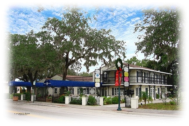
Property Record
737 Main St, Safety Harbor, FL 34695

NEARBY LISTINGS FOR SALE OR LEASE
Property Detail
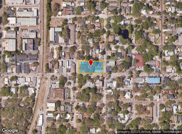
737 Main St
Tampa-St. Petersburg-Clearwater, FL
West Green Springs
03-29-16-96498-027-0080
WEST GREEN SPRINGS BLK 27, LOTS 6 THRU 10 LESS ST & LOT 11
Officebuilding
Pinellas
X
Florida
12103C0127H
11
2024
0.94 AC
2025
North Pinellas
026816
Tampa/St Petersburg
9,027 SF
DEMOGRAPHICS near 737 Main St
1 Mile
3 Mile
5 Mile
2024 Total Population
6,595
53,173
165,523
2029 Population
6,563
53,182
166,365
Pop Growth 2024-2029
(0.49%)
+ 0.02%
+ 0.51%
Average Age
45
47
46
2024 Total Households
2,854
24,620
75,304
HH Growth 2024-2029
(0.74%)
(0.11%)
+ 0.40%
Median Household Inc
$100,380
$62,169
$61,551
Avg Household Size
2.20
2.10
2.10
2024 Avg HH Vehicles
2.00
2.00
2.00
Median Home Value
$401,526
$287,206
$266,263
Median Year Built
1983
1980
1980
Nearby Places
Map Layers
Map Styles
 Street
 Aerial
- Restaurants
- Banks
- Shops
- Fitness
- Groceries
PUBLIC TRANSPORTATION
AIRPORT
St Pete-Clearwater International
DRIVE
WALK
Distance
St Pete-Clearwater International
23 min
11.2 mi
Tampa International
DRIVE
WALK
Distance
Tampa International
26 min
15.4 mi
SALE & LEASE HISTORY
LISTING DATE
SALE/LEASE

Nov 02, 2016
For Sale
May 16, 2018
For Lease
Mar 17, 2017
For Lease
Jan 27, 2017
For Lease
Feb 18, 2025
For Lease
Aug 07, 2018
For Sale
Apr 12, 2017
For Lease
Nearby Properties
Address
Land Use
TOTAL SIZE
Lot Size
Zoning
Address
Land Use
TOTAL SIZE
Lot Size
Zoning
470,181 SF
29.93 AC
Address
Land Use
TOTAL SIZE
Lot Size
Zoning
563,328 SF
27.34 AC
Address
Land Use
TOTAL SIZE
Lot Size
Zoning
435,202 SF
9.80 AC
R3
Address
Land Use
TOTAL SIZE
Lot Size
Zoning
452,179 SF
5.75 AC
R4
Address
Land Use
TOTAL SIZE
Lot Size
Zoning
288,467 SF
43.51 AC
Address
Land Use
TOTAL SIZE
Lot Size
Zoning
305,970 SF
39.74 AC
Address
Land Use
TOTAL SIZE
Lot Size
Zoning
352,647 SF
14.88 AC
Address
Land Use
TOTAL SIZE
Lot Size
Zoning
356,262 SF
15.48 AC
Address
Land Use
TOTAL SIZE
Lot Size
Zoning
171,150 SF
17.58 AC
Address
Land Use
TOTAL SIZE
Lot Size
Zoning
326,008 SF
53.12 AC
Address
Land Use
TOTAL SIZE
Lot Size
Zoning
284,609 SF
15.57 AC
Address
Land Use
TOTAL SIZE
Lot Size
Zoning
662,010 SF
33.76 AC
Address
Land Use
TOTAL SIZE
Lot Size
Zoning
236,972 SF
19.07 AC
Address
Land Use
TOTAL SIZE
Lot Size
Zoning
492,747 SF
19.89 AC
Address
Land Use
TOTAL SIZE
Lot Size
Zoning
321,395 SF
25.22 AC
Address
Land Use
TOTAL SIZE
Lot Size
Zoning
223,944 SF
12.13 AC
Address
Land Use
TOTAL SIZE
Lot Size
Zoning
239,340 SF
17.27 AC
Address
Land Use
TOTAL SIZE
Lot Size
Zoning
258,472 SF
18.23 AC
Address
Land Use
TOTAL SIZE
Lot Size
Zoning
251,016 SF
10.10 AC
AE
Address
Land Use
TOTAL SIZE
Lot Size
Zoning
226,562 SF
11.08 AC
Address
Land Use
TOTAL SIZE
Lot Size
Zoning
215,081 SF
16.60 AC
Address
Land Use
TOTAL SIZE
Lot Size
Zoning
208,637 SF
16.83 AC
M1
Address
Land Use
TOTAL SIZE
Lot Size
Zoning
160,827 SF
20.22 AC
AE
Address
Land Use
TOTAL SIZE
Lot Size
Zoning
176,724 SF
10.92 AC
Address
Land Use
TOTAL SIZE
Lot Size
Zoning
181,169 SF
21.90 AC
AE
Address
Land Use
TOTAL SIZE
Lot Size
Zoning
53,208 SF
38.71 AC
Address
Land Use
TOTAL SIZE
Lot Size
Zoning
131,291 SF
4.24 AC
Address
Land Use
TOTAL SIZE
Lot Size
Zoning
256,181 SF
12.71 AC
Address
Land Use
TOTAL SIZE
Lot Size
Zoning
186,967 SF
16.86 AC
Address
Land Use
TOTAL SIZE
Lot Size
Zoning
244,337 SF
12.97 AC
UZ
The World's #1 Commercial Real Estate Marketplace
Connect with us
© 2025 CoStar Group
The information above has been obtained from sources believed reliable. While we do not doubt its accuracy we have not verified it and make no guarantee, warranty or representation about it. It is your responsibility to independently confirm its accuracy and completeness. Any projections, opinions, assumptions, or estimates used are for example only and do not represent the current or future performance of the property. The value of this transaction to you depends on tax and other factors which should be evaluated by your tax, financial, and legal advisors. You and your advisors should conduct a careful, independent investigation of the property to determine to your satisfaction the suitability of the property for your needs.