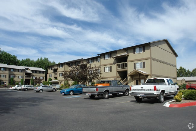
Property Record
737 N Stilson Rd, Boise, ID 83703
NEARBY LISTINGS FOR SALE OR LEASE
Property Detail
737 N Stilson Rd
S0632438513
PAR #8513 OF W2SE4 SEC 32 4N 2E #438510 B
Commercialbuilding
Ada
AE
Idaho
16001C0188J
3.58 AC
2024
Veterans Park
2025
Boise City/Nampa
000402
Boise City, ID
63,476 SF
DEMOGRAPHICS near 737 N Stilson Rd
1 Mile
3 Mile
5 Mile
2024 Total Population
11,568
100,842
208,942
2029 Population
13,075
114,096
236,466
Pop Growth 2024-2029
+ 13.03%
+ 13.14%
+ 13.17%
Average Age
39
40
40
2024 Total Households
4,980
44,513
89,424
HH Growth 2024-2029
+ 13.27%
+ 13.57%
+ 13.58%
Median Household Inc
$59,351
$60,941
$64,946
Avg Household Size
2.20
2.10
2.20
2024 Avg HH Vehicles
2.00
2.00
2.00
Median Home Value
$434,059
$450,666
$441,449
Median Year Built
1980
1980
1984
Nearby Places
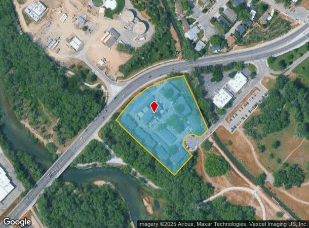
Map Layers
Map Styles
 Street
 Aerial
- Restaurants
- Banks
- Shops
- Fitness
- Groceries
PUBLIC TRANSPORTATION
AIRPORT
Boise Air Trml/Gowen Field
DRIVE
WALK
Distance
Boise Air Trml/Gowen Field
19 min
7.8 mi
Nearby Properties
Address
Land Use
TOTAL SIZE
Lot Size
Zoning
Address
Land Use
TOTAL SIZE
Lot Size
Zoning
369,584 SF
1 AC
ZC-259
Address
Land Use
TOTAL SIZE
Lot Size
Zoning
646,787 SF
27.37 AC
ZC-243
Address
Land Use
TOTAL SIZE
Lot Size
Zoning
434,370 SF
0.56 AC
ZC-259
Address
Land Use
TOTAL SIZE
Lot Size
Zoning
129,663 SF
0.92 AC
ZC-259
Address
Land Use
TOTAL SIZE
Lot Size
Zoning
13.90 AC
R-2
Address
Land Use
TOTAL SIZE
Lot Size
Zoning
4.02 AC
C-2/DA
Address
Land Use
TOTAL SIZE
Lot Size
Zoning
279,694 SF
2.09 AC
ZC-264
Address
Land Use
TOTAL SIZE
Lot Size
Zoning
402,504 SF
5.78 AC
ZC-259
Address
Land Use
TOTAL SIZE
Lot Size
Zoning
334,334 SF
3.21 AC
ZC-259
Address
Land Use
TOTAL SIZE
Lot Size
Zoning
156,000 SF
4.57 AC
ZC-241
Address
Land Use
TOTAL SIZE
Lot Size
Zoning
207,033 SF
10.67 AC
ZC-243
Address
Land Use
TOTAL SIZE
Lot Size
Zoning
204,396 SF
0.82 AC
ZC-261
Address
Land Use
TOTAL SIZE
Lot Size
Zoning
366,126 SF
0.82 AC
ZC-259
Address
Land Use
TOTAL SIZE
Lot Size
Zoning
223,171 SF
0.85 AC
ZC-264
Address
Land Use
TOTAL SIZE
Lot Size
Zoning
225,032 SF
12.75 AC
R-3
Address
Land Use
TOTAL SIZE
Lot Size
Zoning
359,820 SF
1.79 AC
ZC-259
Address
Land Use
TOTAL SIZE
Lot Size
Zoning
459,218 SF
1.79 AC
ZC-241
Address
Land Use
TOTAL SIZE
Lot Size
Zoning
159,859 SF
0.80 AC
ZC-264
Address
Land Use
TOTAL SIZE
Lot Size
Zoning
249,800 SF
12.99 AC
ZC-243
Address
Land Use
TOTAL SIZE
Lot Size
Zoning
245,000 SF
12.28 AC
R-2
Address
Land Use
TOTAL SIZE
Lot Size
Zoning
205,522 SF
0.82 AC
ZC-259
Address
Land Use
TOTAL SIZE
Lot Size
Zoning
276,099 SF
8.70 AC
ZC-261
Address
Land Use
TOTAL SIZE
Lot Size
Zoning
216,371 SF
0.78 AC
ZC-261
Address
Land Use
TOTAL SIZE
Lot Size
Zoning
151,285 SF
9.54 AC
R-1C
Address
Land Use
TOTAL SIZE
Lot Size
Zoning
189,100 SF
0.60 AC
ZC-259
Address
Land Use
TOTAL SIZE
Lot Size
Zoning
222,379 SF
1.37 AC
M
Address
Land Use
TOTAL SIZE
Lot Size
Zoning
150,584 SF
6.77 AC
M
Address
Land Use
TOTAL SIZE
Lot Size
Zoning
182,950 SF
0.41 AC
ZC-259
Address
Land Use
TOTAL SIZE
Lot Size
Zoning
96,969 SF
2 AC
ZC-261
Address
Land Use
TOTAL SIZE
Lot Size
Zoning
211,039 SF
12.21 AC
ZC-243
The World's #1 Commercial Real Estate Marketplace
Connect with us
© 2026 CoStar Group
The information above has been obtained from sources believed reliable. While we do not doubt its accuracy we have not verified it and make no guarantee, warranty or representation about it. It is your responsibility to independently confirm its accuracy and completeness. Any projections, opinions, assumptions, or estimates used are for example only and do not represent the current or future performance of the property. The value of this transaction to you depends on tax and other factors which should be evaluated by your tax, financial, and legal advisors. You and your advisors should conduct a careful, independent investigation of the property to determine to your satisfaction the suitability of the property for your needs.