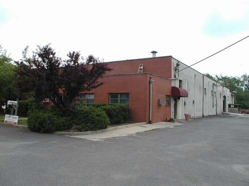
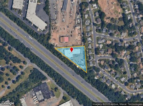
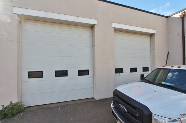
Property Record
737 New Durham Rd, Edison, NJ 08817

NEARBY LISTINGS FOR SALE OR LEASE
Property Detail
737 New Durham Rd
New York-Jersey City-White Plains, NY-NJ
1.50 AC
05-00049-0000-00009
Middlesex
Industrialgeneral
New Jersey
X
9
34023C0042F
1.50 AC
2024
Exit 10
2025
Northern New Jersey
001504
DEMOGRAPHICS near 737 New Durham Rd
1 Mile
3 Mile
5 Mile
2024 Total Population
12,015
112,536
300,141
2029 Population
11,828
111,796
298,908
Pop Growth 2024-2029
(1.56%)
(0.66%)
(0.41%)
Average Age
38
40
39
2024 Total Households
4,300
39,087
101,230
HH Growth 2024-2029
(1.60%)
(0.78%)
(0.40%)
Median Household Inc
$123,922
$116,283
$106,198
Avg Household Size
2.70
2.80
2.80
2024 Avg HH Vehicles
2.00
2.00
2.00
Median Home Value
$438,821
$442,160
$410,826
Median Year Built
1973
1970
1969
Nearby Places
Map Layers
Map Styles
 Street
 Aerial
- Restaurants
- Banks
- Shops
- Fitness
- Groceries
PUBLIC TRANSPORTATION
COMMUTER RAIL
Metuchen (Northeast Corridor Line - NJ Transit Commuter Rail (NJ Transit))
DRIVE
WALK
Distance
Metuchen (Northeast Corridor Line - NJ Transit Commuter Rail (NJ Transit))
10 min
5.5 mi
Edison (Northeast Corridor Line - NJ Transit Commuter Rail (NJ Transit))
DRIVE
WALK
Distance
Edison (Northeast Corridor Line - NJ Transit Commuter Rail (NJ Transit))
11 min
6.0 mi
AIRPORT
Newark Liberty International
DRIVE
WALK
Distance
Newark Liberty International
35 min
27.7 mi
Trenton Mercer
DRIVE
WALK
Distance
Trenton Mercer
53 min
38.6 mi
LaGuardia
DRIVE
WALK
Distance
LaGuardia
66 min
44.2 mi
Freight Ports
New York Container Terminal
DRIVE
WALK
Distance
New York Container Terminal
29 min
22.0 mi
SALE & LEASE HISTORY
LISTING DATE
SALE/LEASE

Sep 24, 2018
For Lease
Oct 18, 2024
For Lease
Jan 31, 2020
For Lease
Nearby Properties
Address
Land Use
TOTAL SIZE
Lot Size
Zoning
Address
Land Use
TOTAL SIZE
Lot Size
Zoning
37.46 AC
EI
Address
Land Use
TOTAL SIZE
Lot Size
Zoning
65.84 AC
PB
Address
Land Use
TOTAL SIZE
Lot Size
Zoning
138,550 SF
104.63 AC
E
Address
Land Use
TOTAL SIZE
Lot Size
Zoning
23,140 SF
107.63 AC
E
Address
Land Use
TOTAL SIZE
Lot Size
Zoning
165.43 AC
EI
Address
Land Use
TOTAL SIZE
Lot Size
Zoning
147.45 AC
RRRD
Address
Land Use
TOTAL SIZE
Lot Size
Zoning
137.89 AC
RAA
Address
Land Use
TOTAL SIZE
Lot Size
Zoning
49.83 AC
LI
Address
Land Use
TOTAL SIZE
Lot Size
Zoning
103,973 SF
51.10 AC
LI1
Address
Land Use
TOTAL SIZE
Lot Size
Zoning
55.57 AC
LI
Address
Land Use
TOTAL SIZE
Lot Size
Zoning
40.78 AC
RRRD
Address
Land Use
TOTAL SIZE
Lot Size
Zoning
50.50 AC
LI
Address
Land Use
TOTAL SIZE
Lot Size
Zoning
0.21 AC
LR
Address
Land Use
TOTAL SIZE
Lot Size
Zoning
35.98 AC
LI
Address
Land Use
TOTAL SIZE
Lot Size
Zoning
16,734 SF
9.37 AC
RM
Address
Land Use
TOTAL SIZE
Lot Size
Zoning
34.14 AC
LR
Address
Land Use
TOTAL SIZE
Lot Size
Zoning
3.18 AC
Address
Land Use
TOTAL SIZE
Lot Size
Zoning
162.66 AC
LI
Address
Land Use
TOTAL SIZE
Lot Size
Zoning
95,652 SF
38.24 AC
R20
Address
Land Use
TOTAL SIZE
Lot Size
Zoning
164.79 AC
LI
Address
Land Use
TOTAL SIZE
Lot Size
Zoning
23.32 AC
RBTH
Address
Land Use
TOTAL SIZE
Lot Size
Zoning
107,800 SF
6.24 AC
LI1
Address
Land Use
TOTAL SIZE
Lot Size
Zoning
4.85 AC
TV
Address
Land Use
TOTAL SIZE
Lot Size
Zoning
5.18 AC
Address
Land Use
TOTAL SIZE
Lot Size
Zoning
25 AC
LR
Address
Land Use
TOTAL SIZE
Lot Size
Zoning
26.07 AC
LR
Address
Land Use
TOTAL SIZE
Lot Size
Zoning
19.50 AC
LR
Address
Land Use
TOTAL SIZE
Lot Size
Zoning
50 AC
LI
Address
Land Use
TOTAL SIZE
Lot Size
Zoning
10.50 AC
LI
Address
Land Use
TOTAL SIZE
Lot Size
Zoning
22.50 AC
LR
The World's #1 Commercial Real Estate Marketplace
Connect with us
© 2025 CoStar Group
The information above has been obtained from sources believed reliable. While we do not doubt its accuracy we have not verified it and make no guarantee, warranty or representation about it. It is your responsibility to independently confirm its accuracy and completeness. Any projections, opinions, assumptions, or estimates used are for example only and do not represent the current or future performance of the property. The value of this transaction to you depends on tax and other factors which should be evaluated by your tax, financial, and legal advisors. You and your advisors should conduct a careful, independent investigation of the property to determine to your satisfaction the suitability of the property for your needs.