Property Record
707 W Cleveland Ave, Milwaukee, WI 53215
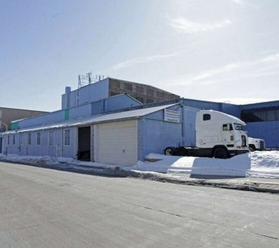

This Property Is For Sale
Current Lease Availabilities
NEARBY LISTINGS FOR SALE OR LEASE
Property Detail
707 W Cleveland Ave
Milwaukee-Waukesha, WI
Certified Surv Map 5360
507-1341-000-1
CERTIFIED SURVEY MAP NO 5360 IN SW 1/4 SEC 8-6-22 PARCEL 1
Warehouse
Milwaukee
X
Wisconsin
55079C0156E
1
2024
1.77 AC
2024
Milwaukee Near SW
018600
Milwaukee/Madison
127,970 SF
DEMOGRAPHICS near 707 W Cleveland Ave
1 Mile
3 Mile
5 Mile
2024 Total Population
31,647
161,260
371,870
2029 Population
30,814
157,317
363,994
Pop Growth 2024-2029
(2.63%)
(2.45%)
(2.12%)
Average Age
33
36
37
2024 Total Households
11,016
62,618
159,865
HH Growth 2024-2029
(2.73%)
(2.43%)
(2.07%)
Median Household Inc
$47,619
$51,402
$52,977
Avg Household Size
2.80
2.50
2.20
2024 Avg HH Vehicles
2.00
2.00
1.00
Median Home Value
$143,769
$170,221
$181,746
Median Year Built
1946
1947
1951
Nearby Places
Map Layers
Map Styles
 Street
 Aerial
- Restaurants
- Banks
- Shops
- Fitness
- Groceries
PUBLIC TRANSPORTATION
COMMUTER RAIL
DRIVE
WALK
Distance
10 min
4.0 mi
DRIVE
WALK
Distance
12 min
4.2 mi
AIRPORT
General Mitchell International
DRIVE
WALK
Distance
General Mitchell International
12 min
4.3 mi
Freight Ports
Port Milwaukee
DRIVE
WALK
Distance
Port Milwaukee
5 min
1.4 mi
Nearby Properties
Address
Land Use
TOTAL SIZE
Lot Size
Zoning
Address
Land Use
TOTAL SIZE
Lot Size
Zoning
41.05 AC
IO2
Address
Land Use
TOTAL SIZE
Lot Size
Zoning
523,726 SF
0.79 AC
C9B(B)
Address
Land Use
TOTAL SIZE
Lot Size
Zoning
607,577 SF
1.67 AC
PD
Address
Land Use
TOTAL SIZE
Lot Size
Zoning
370,160 SF
2.93 AC
C9F(A)
Address
Land Use
TOTAL SIZE
Lot Size
Zoning
414,410 SF
2.16 AC
C9F(A)
Address
Land Use
TOTAL SIZE
Lot Size
Zoning
173,610 SF
1.70 AC
IM
Address
Land Use
TOTAL SIZE
Lot Size
Zoning
491,759 SF
3 AC
C9F(A)
Address
Land Use
TOTAL SIZE
Lot Size
Zoning
319,559 SF
6.29 AC
PD
Address
Land Use
TOTAL SIZE
Lot Size
Zoning
179 AC
IH
Address
Land Use
TOTAL SIZE
Lot Size
Zoning
204,809 SF
1.04 AC
IM
Address
Land Use
TOTAL SIZE
Lot Size
Zoning
245,485 SF
6.30 AC
IM
Address
Land Use
TOTAL SIZE
Lot Size
Zoning
166,554 SF
0.66 AC
C9F(A)
Address
Land Use
TOTAL SIZE
Lot Size
Zoning
1,709,128 SF
9.32 AC
PD
Address
Land Use
TOTAL SIZE
Lot Size
Zoning
12.02 AC
IO2
Address
Land Use
TOTAL SIZE
Lot Size
Zoning
236,218 SF
1.47 AC
C9F(A)
Address
Land Use
TOTAL SIZE
Lot Size
Zoning
15.43 AC
PD
Address
Land Use
TOTAL SIZE
Lot Size
Zoning
48.34 AC
IO1
Address
Land Use
TOTAL SIZE
Lot Size
Zoning
122,695 SF
0.39 AC
C9G
Address
Land Use
TOTAL SIZE
Lot Size
Zoning
2.85 AC
C9G
Address
Land Use
TOTAL SIZE
Lot Size
Zoning
110,000 SF
7.59 AC
TL
Address
Land Use
TOTAL SIZE
Lot Size
Zoning
2,610 SF
1.04 AC
IM
Address
Land Use
TOTAL SIZE
Lot Size
Zoning
86.13 AC
IH
Address
Land Use
TOTAL SIZE
Lot Size
Zoning
11.38 AC
TL
Address
Land Use
TOTAL SIZE
Lot Size
Zoning
120,000 SF
1.10 AC
IM
Address
Land Use
TOTAL SIZE
Lot Size
Zoning
222,100 SF
1.29 AC
PD
Address
Land Use
TOTAL SIZE
Lot Size
Zoning
197,354 SF
18 AC
CS
Address
Land Use
TOTAL SIZE
Lot Size
Zoning
0.43 AC
RT3
Address
Land Use
TOTAL SIZE
Lot Size
Zoning
183,291 SF
11.48 AC
IM
Address
Land Use
TOTAL SIZE
Lot Size
Zoning
95,788 SF
1.04 AC
IM
Address
Land Use
TOTAL SIZE
Lot Size
Zoning
112,438 SF
0.59 AC
C9F(A)
The World's #1 Commercial Real Estate Marketplace
Connect with us
© 2026 CoStar Group
The information above has been obtained from sources believed reliable. While we do not doubt its accuracy we have not verified it and make no guarantee, warranty or representation about it. It is your responsibility to independently confirm its accuracy and completeness. Any projections, opinions, assumptions, or estimates used are for example only and do not represent the current or future performance of the property. The value of this transaction to you depends on tax and other factors which should be evaluated by your tax, financial, and legal advisors. You and your advisors should conduct a careful, independent investigation of the property to determine to your satisfaction the suitability of the property for your needs.