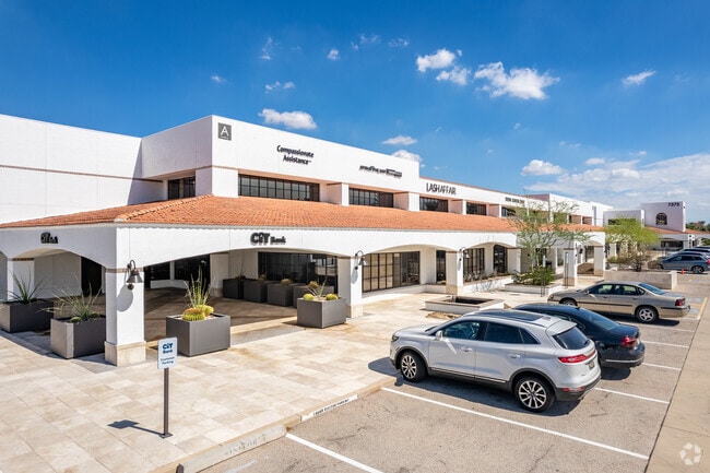
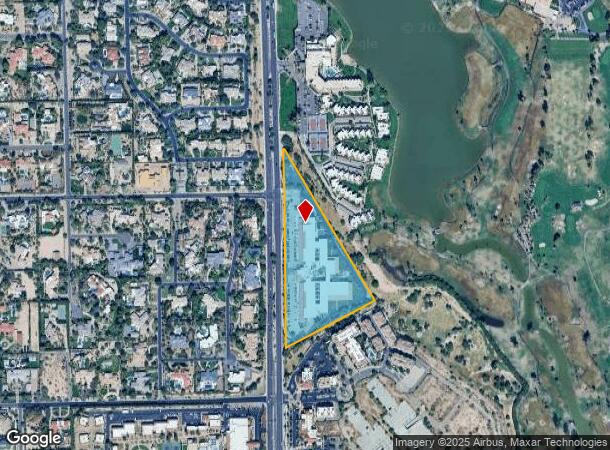
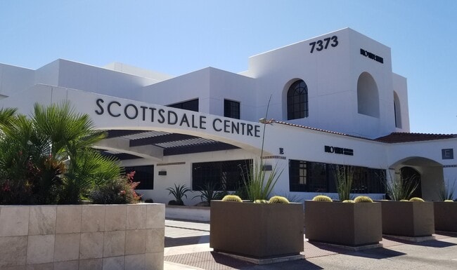
Property Record
7373 N Scottsdale Rd, Paradise Valley, AZ 85253

Current Lease Availabilities
NEARBY LISTINGS FOR SALE OR LEASE
Property Detail
7373 N Scottsdale Rd
Phoenix-Mesa-Scottsdale, AZ
TH PT SEC 2 DAF BEG W4 COR SEC 2 TH N 01D 13M W 316.72F TO NW COR S2 SW4 SW4 NW4 TH S 88D 52M E 73.06F TH S 30D 25M E 1150.43F TO SE COR NW4 NW4 SW4 SD SEC TH S 62D 41M W 685.37F TO PT ON S LN N2 SW4 NW4 SW4 SD SEC TH N 88D 32M W 40.01F TH N 990.39F
174-23-002N
Maricopa
Officebuilding
Arizona
2025
8.71 AC
2025
Central Scottsdale
216835
Phoenix
328,282 SF
DEMOGRAPHICS near 7373 N Scottsdale Rd
1 Mile
3 Mile
5 Mile
2024 Total Population
6,955
64,744
177,832
2029 Population
7,854
71,632
195,567
Pop Growth 2024-2029
+ 12.93%
+ 10.64%
+ 9.97%
Average Age
51
48
45
2024 Total Households
3,422
31,962
84,665
HH Growth 2024-2029
+ 13.15%
+ 10.88%
+ 10.31%
Median Household Inc
$116,024
$104,679
$98,847
Avg Household Size
2.00
2.00
2.00
2024 Avg HH Vehicles
2.00
2.00
2.00
Median Home Value
$805,708
$720,701
$699,222
Median Year Built
1992
1982
1981
Nearby Places
Map Layers
Map Styles
 Street
 Aerial
- Restaurants
- Banks
- Shops
- Fitness
- Groceries
PUBLIC TRANSPORTATION
AIRPORT
Phoenix Sky Harbor International
DRIVE
WALK
Distance
Phoenix Sky Harbor International
23 min
12.1 mi
Phoenix-Mesa Gateway
DRIVE
WALK
Distance
Phoenix-Mesa Gateway
46 min
32.0 mi
Freight Ports
Port of San Diego
DRIVE
WALK
Distance
Port of San Diego
416 min
368.7 mi
Nearby Properties
Address
Land Use
TOTAL SIZE
Lot Size
Zoning
Address
Land Use
TOTAL SIZE
Lot Size
Zoning
2,636,740 SF
21.88 AC
C-DT
Address
Land Use
TOTAL SIZE
Lot Size
Zoning
33,483 SF
7.82 AC
PF
Address
Land Use
TOTAL SIZE
Lot Size
Zoning
981,325 SF
8.31 AC
Address
Land Use
TOTAL SIZE
Lot Size
Zoning
367,367 SF
37.89 AC
R-43
Address
Land Use
TOTAL SIZE
Lot Size
Zoning
623,263 SF
27.34 AC
M-H
Address
Land Use
TOTAL SIZE
Lot Size
Zoning
440,573 SF
19.10 AC
SUPR
Address
Land Use
TOTAL SIZE
Lot Size
Zoning
517,502 SF
21.26 AC
SUPR
Address
Land Use
TOTAL SIZE
Lot Size
Zoning
457,979 SF
9.26 AC
CO
Address
Land Use
TOTAL SIZE
Lot Size
Zoning
734,506 SF
7.75 AC
C-T
Address
Land Use
TOTAL SIZE
Lot Size
Zoning
22,630 SF
1.06 AC
SUPP
Address
Land Use
TOTAL SIZE
Lot Size
Zoning
515,127 SF
7.57 AC
C-T
Address
Land Use
TOTAL SIZE
Lot Size
Zoning
289,633 SF
9.11 AC
R-10
Address
Land Use
TOTAL SIZE
Lot Size
Zoning
590,903 SF
9.41 AC
C-DT
Address
Land Use
TOTAL SIZE
Lot Size
Zoning
245,175 SF
6.94 AC
DDRU2
Address
Land Use
TOTAL SIZE
Lot Size
Zoning
250,415 SF
21 AC
I-P
Address
Land Use
TOTAL SIZE
Lot Size
Zoning
355,399 SF
7.13 AC
C-C
Address
Land Use
TOTAL SIZE
Lot Size
Zoning
163,075 SF
17.77 AC
C-R
Address
Land Use
TOTAL SIZE
Lot Size
Zoning
121,740 SF
22.13 AC
SUPR
Address
Land Use
TOTAL SIZE
Lot Size
Zoning
158,895 SF
6.83 AC
R-43
Address
Land Use
TOTAL SIZE
Lot Size
Zoning
345,713 SF
18.25 AC
M-H
Address
Land Use
TOTAL SIZE
Lot Size
Zoning
138,984 SF
14.30 AC
C-C
Address
Land Use
TOTAL SIZE
Lot Size
Zoning
194,044 SF
4.93 AC
C-2
Address
Land Use
TOTAL SIZE
Lot Size
Zoning
145,146 SF
8.21 AC
M-H
Address
Land Use
TOTAL SIZE
Lot Size
Zoning
358,139 SF
5.31 AC
PUD
Address
Land Use
TOTAL SIZE
Lot Size
Zoning
270,059 SF
10.61 AC
M-H
Address
Land Use
TOTAL SIZE
Lot Size
Zoning
132,764 SF
3.97 AC
DDRU2
Address
Land Use
TOTAL SIZE
Lot Size
Zoning
359,568 SF
19 AC
RT
Address
Land Use
TOTAL SIZE
Lot Size
Zoning
352,440 SF
17.51 AC
R-5
Address
Land Use
TOTAL SIZE
Lot Size
Zoning
240,248 SF
4.67 AC
C-T
Address
Land Use
TOTAL SIZE
Lot Size
Zoning
369,186 SF
12.45 AC
The World's #1 Commercial Real Estate Marketplace
Connect with us
© 2026 CoStar Group
The information above has been obtained from sources believed reliable. While we do not doubt its accuracy we have not verified it and make no guarantee, warranty or representation about it. It is your responsibility to independently confirm its accuracy and completeness. Any projections, opinions, assumptions, or estimates used are for example only and do not represent the current or future performance of the property. The value of this transaction to you depends on tax and other factors which should be evaluated by your tax, financial, and legal advisors. You and your advisors should conduct a careful, independent investigation of the property to determine to your satisfaction the suitability of the property for your needs.