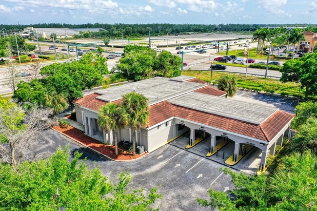
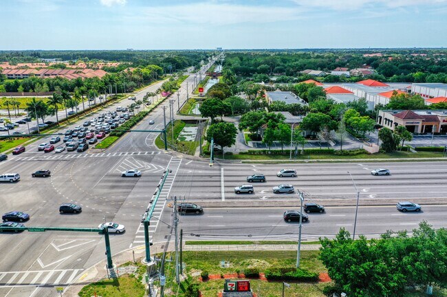
Property Record
7379 Davis Blvd, Naples, FL 34104


Current Lease Availabilities
NEARBY LISTINGS FOR SALE OR LEASE
Property Detail
7379 Davis Blvd
Naples-Marco Island, FL
Countryside Berkshire Lk 1
28430280100
COUNTRYSIDE AT BERKSHIRE LAKES SEC 1 S 240 FT OF E 176 FT OF TRACT 10
Financialbuilding
Collier
AE
Florida
12021C0413J
10.1
2024
0.97 AC
2025
East Naples
010520
Southwest Florida
3,348 SF
DEMOGRAPHICS near 7379 Davis Blvd
1 Mile
3 Mile
5 Mile
2024 Total Population
8,637
63,667
136,477
2029 Population
9,972
72,606
155,053
Pop Growth 2024-2029
+ 15.46%
+ 14.04%
+ 13.61%
Average Age
55
51
48
2024 Total Households
4,106
28,550
57,798
HH Growth 2024-2029
+ 15.12%
+ 14.05%
+ 13.75%
Median Household Inc
$70,213
$64,244
$66,678
Avg Household Size
2.00
2.10
2.20
2024 Avg HH Vehicles
1.00
2.00
2.00
Median Home Value
$303,782
$288,498
$343,718
Median Year Built
1996
1993
1994
Nearby Places
Map Layers
Map Styles
 Street
 Aerial
- Restaurants
- Banks
- Shops
- Fitness
- Groceries
PUBLIC TRANSPORTATION
AIRPORT
Southwest Florida International
DRIVE
WALK
Distance
Southwest Florida International
44 min
33.2 mi
Freight Ports
Port Everglades
DRIVE
WALK
Distance
Port Everglades
116 min
102.3 mi
Nearby Properties
Address
Land Use
TOTAL SIZE
Lot Size
Zoning
Address
Land Use
TOTAL SIZE
Lot Size
Zoning
1,429,641 SF
45.28 AC
P
Address
Land Use
TOTAL SIZE
Lot Size
Zoning
325,841 SF
39.86 AC
PUD
Address
Land Use
TOTAL SIZE
Lot Size
Zoning
359,711 SF
14.89 AC
Address
Land Use
TOTAL SIZE
Lot Size
Zoning
362,032 SF
15.97 AC
PUD
Address
Land Use
TOTAL SIZE
Lot Size
Zoning
363,413 SF
33.78 AC
Address
Land Use
TOTAL SIZE
Lot Size
Zoning
378,021 SF
18.99 AC
PUD
Address
Land Use
TOTAL SIZE
Lot Size
Zoning
340,436 SF
18.10 AC
PUD
Address
Land Use
TOTAL SIZE
Lot Size
Zoning
368,668 SF
36.96 AC
PUD
Address
Land Use
TOTAL SIZE
Lot Size
Zoning
279,871 SF
11.52 AC
Address
Land Use
TOTAL SIZE
Lot Size
Zoning
371,884 SF
22.64 AC
MPUD
Address
Land Use
TOTAL SIZE
Lot Size
Zoning
344,520 SF
21.91 AC
PUD
Address
Land Use
TOTAL SIZE
Lot Size
Zoning
170,126 SF
50 AC
PUD
Address
Land Use
TOTAL SIZE
Lot Size
Zoning
185,464 SF
68.94 AC
A
Address
Land Use
TOTAL SIZE
Lot Size
Zoning
58,639 SF
20 AC
PUD
Address
Land Use
TOTAL SIZE
Lot Size
Zoning
70,944 SF
9.51 AC
P
Address
Land Use
TOTAL SIZE
Lot Size
Zoning
168,247 SF
25.60 AC
RMF-6
Address
Land Use
TOTAL SIZE
Lot Size
Zoning
240,746 SF
30.45 AC
PUD
Address
Land Use
TOTAL SIZE
Lot Size
Zoning
194,882 SF
17.30 AC
PUD
Address
Land Use
TOTAL SIZE
Lot Size
Zoning
93,756 SF
11.53 AC
PUD
Address
Land Use
TOTAL SIZE
Lot Size
Zoning
200,272 SF
7.40 AC
PUD
Address
Land Use
TOTAL SIZE
Lot Size
Zoning
122,929 SF
17.58 AC
PUD
Address
Land Use
TOTAL SIZE
Lot Size
Zoning
98,859 SF
22 AC
PUD
Address
Land Use
TOTAL SIZE
Lot Size
Zoning
263,863 SF
20.32 AC
PUD
Address
Land Use
TOTAL SIZE
Lot Size
Zoning
106,904 SF
24.56 AC
PUD
Address
Land Use
TOTAL SIZE
Lot Size
Zoning
100,697 SF
8.84 AC
PUD
Address
Land Use
TOTAL SIZE
Lot Size
Zoning
277,227 SF
12.05 AC
PUD
Address
Land Use
TOTAL SIZE
Lot Size
Zoning
141,042 SF
17.69 AC
RMF-6
Address
Land Use
TOTAL SIZE
Lot Size
Zoning
104,183 SF
17.87 AC
PUD
Address
Land Use
TOTAL SIZE
Lot Size
Zoning
122,611 SF
6.15 AC
PUD
Address
Land Use
TOTAL SIZE
Lot Size
Zoning
191,660 SF
18.87 AC
PUD
The World's #1 Commercial Real Estate Marketplace
Connect with us
© 2026 CoStar Group
The information above has been obtained from sources believed reliable. While we do not doubt its accuracy we have not verified it and make no guarantee, warranty or representation about it. It is your responsibility to independently confirm its accuracy and completeness. Any projections, opinions, assumptions, or estimates used are for example only and do not represent the current or future performance of the property. The value of this transaction to you depends on tax and other factors which should be evaluated by your tax, financial, and legal advisors. You and your advisors should conduct a careful, independent investigation of the property to determine to your satisfaction the suitability of the property for your needs.