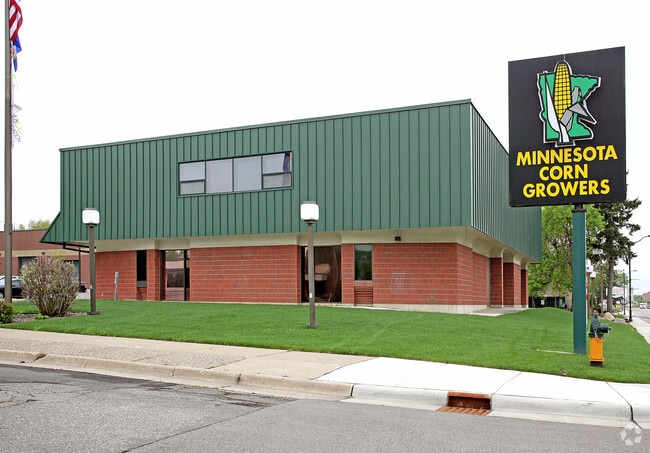
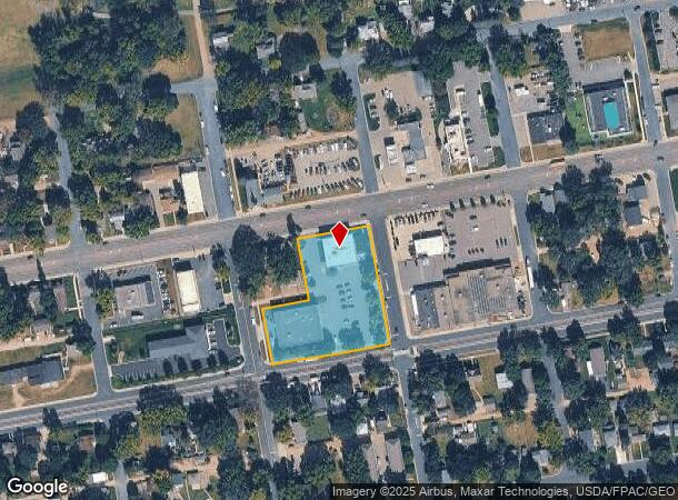
Property Record
738 1St Ave E, Shakopee, MN 55379


NEARBY LISTINGS FOR SALE OR LEASE
Property Detail
738 1St Ave E
Minneapolis/St Paul
Minnesota Corn Growers
Minneapolis-St. Paul-Bloomington, MN-WI
MINNESOTA CORN GROWERS LOT 001 BLOCK 001
27-409-001-0
Scott
Charitableorganization
Minnesota
0
1
2025
1.63 AC
080400
Scott County Outlying
14,425 SF
DEMOGRAPHICS near 738 1St Ave E
1 Mile
3 Mile
5 Mile
2024 Total Population
9,050
45,607
107,338
2029 Population
9,677
48,339
112,581
Pop Growth 2024-2029
+ 6.93%
+ 5.99%
+ 4.88%
Average Age
39
37
39
2024 Total Households
3,525
15,869
39,275
HH Growth 2024-2029
+ 7.46%
+ 6.38%
+ 5.03%
Median Household Inc
$56,140
$97,024
$100,883
Avg Household Size
2.40
2.80
2.70
2024 Avg HH Vehicles
2.00
2.00
2.00
Median Home Value
$255,618
$326,707
$370,448
Median Year Built
1979
1997
1994
Nearby Places
Map Layers
Map Styles
 Street
 Aerial
- Restaurants
- Banks
- Shops
- Fitness
- Groceries
PUBLIC TRANSPORTATION
AIRPORT
Minneapolis-St Paul International/Wold-Chamberlain
DRIVE
WALK
Distance
Minneapolis-St Paul International/Wold-Chamberlain
30 min
20.9 mi
Freight Ports
Port Milwaukee
DRIVE
WALK
Distance
Port Milwaukee
399 min
358.1 mi
SALE & LEASE HISTORY
LISTING DATE
SALE/LEASE

Apr 05, 2021
For Sale
Nearby Properties
Address
Land Use
TOTAL SIZE
Lot Size
Zoning
Address
Land Use
TOTAL SIZE
Lot Size
Zoning
625,426 SF
40.47 AC
Address
Land Use
TOTAL SIZE
Lot Size
Zoning
66.08 AC
Address
Land Use
TOTAL SIZE
Lot Size
Zoning
475,471 SF
12.90 AC
Address
Land Use
TOTAL SIZE
Lot Size
Zoning
10.02 AC
Address
Land Use
TOTAL SIZE
Lot Size
Zoning
151,074 SF
17.27 AC
Address
Land Use
TOTAL SIZE
Lot Size
Zoning
1,008,768 SF
93.90 AC
Address
Land Use
TOTAL SIZE
Lot Size
Zoning
33.02 AC
Address
Land Use
TOTAL SIZE
Lot Size
Zoning
Address
Land Use
TOTAL SIZE
Lot Size
Zoning
600,000 SF
31.21 AC
Address
Land Use
TOTAL SIZE
Lot Size
Zoning
397,347 SF
28.62 AC
Address
Land Use
TOTAL SIZE
Lot Size
Zoning
374,700 SF
24.09 AC
Address
Land Use
TOTAL SIZE
Lot Size
Zoning
16.08 AC
Address
Land Use
TOTAL SIZE
Lot Size
Zoning
Address
Land Use
TOTAL SIZE
Lot Size
Zoning
51,272 SF
2.11 AC
Address
Land Use
TOTAL SIZE
Lot Size
Zoning
1.80 AC
Address
Land Use
TOTAL SIZE
Lot Size
Zoning
164,809 SF
7.28 AC
Address
Land Use
TOTAL SIZE
Lot Size
Zoning
198,754 SF
27.50 AC
Address
Land Use
TOTAL SIZE
Lot Size
Zoning
52,280 SF
12.15 AC
Address
Land Use
TOTAL SIZE
Lot Size
Zoning
302,500 SF
23.79 AC
Address
Land Use
TOTAL SIZE
Lot Size
Zoning
Address
Land Use
TOTAL SIZE
Lot Size
Zoning
191,395 SF
5.16 AC
Address
Land Use
TOTAL SIZE
Lot Size
Zoning
299,600 SF
16.48 AC
Address
Land Use
TOTAL SIZE
Lot Size
Zoning
109,720 SF
10.65 AC
Address
Land Use
TOTAL SIZE
Lot Size
Zoning
242,004 SF
16.54 AC
Address
Land Use
TOTAL SIZE
Lot Size
Zoning
231,842 SF
21.61 AC
Address
Land Use
TOTAL SIZE
Lot Size
Zoning
138,865 SF
12.55 AC
Address
Land Use
TOTAL SIZE
Lot Size
Zoning
131,154 SF
21.76 AC
Address
Land Use
TOTAL SIZE
Lot Size
Zoning
136,637 SF
11 AC
Address
Land Use
TOTAL SIZE
Lot Size
Zoning
203,280 SF
12.40 AC
Address
Land Use
TOTAL SIZE
Lot Size
Zoning
188,841 SF
12.09 AC
The World's #1 Commercial Real Estate Marketplace
Connect with us
© 2026 CoStar Group
The information above has been obtained from sources believed reliable. While we do not doubt its accuracy we have not verified it and make no guarantee, warranty or representation about it. It is your responsibility to independently confirm its accuracy and completeness. Any projections, opinions, assumptions, or estimates used are for example only and do not represent the current or future performance of the property. The value of this transaction to you depends on tax and other factors which should be evaluated by your tax, financial, and legal advisors. You and your advisors should conduct a careful, independent investigation of the property to determine to your satisfaction the suitability of the property for your needs.