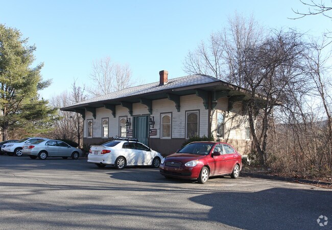
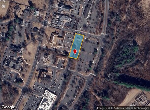
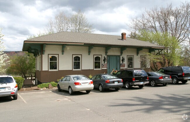
Property Record
738 Hopmeadow St, Simsbury, CT 06070
NEARBY LISTINGS FOR SALE OR LEASE
Property Detail
738 Hopmeadow St
SIMS-000010H-000227-000003
Hartford
Officebuilding
Connecticut
X
3
09003C0331F
0.34 AC
2025
Simsbury
2025
Hartford
466300
Hartford-West Hartford-East Hartford, CT
1,050 SF
DEMOGRAPHICS near 738 Hopmeadow St
1 Mile
3 Mile
5 Mile
2024 Total Population
2,551
17,646
44,719
2029 Population
2,541
17,628
44,695
Pop Growth 2024-2029
(0.39%)
(0.10%)
(0.05%)
Average Age
45
44
44
2024 Total Households
1,062
7,130
18,445
HH Growth 2024-2029
(0.56%)
(0.14%)
(0.08%)
Median Household Inc
$105,271
$130,032
$120,443
Avg Household Size
2.30
2.40
2.40
2024 Avg HH Vehicles
2.00
2.00
2.00
Median Home Value
$338,958
$360,477
$344,399
Median Year Built
1969
1973
1974
Nearby Places
Map Layers
Map Styles
 Street
 Aerial
- Restaurants
- Banks
- Shops
- Fitness
- Groceries
PUBLIC TRANSPORTATION
AIRPORT
Bradley International
DRIVE
WALK
Distance
Bradley International
31 min
13.4 mi
Freight Ports
Port of New Haven
DRIVE
WALK
Distance
Port of New Haven
69 min
43.8 mi
SALE & LEASE HISTORY
LISTING DATE
SALE/LEASE

Jan 11, 2017
For Lease
Nearby Properties
Address
Land Use
TOTAL SIZE
Lot Size
Zoning
Address
Land Use
TOTAL SIZE
Lot Size
Zoning
35.44 AC
HSFBC
Address
Land Use
TOTAL SIZE
Lot Size
Zoning
46.20 AC
R-40
Address
Land Use
TOTAL SIZE
Lot Size
Zoning
9,882 SF
181.60 AC
R-40
Address
Land Use
TOTAL SIZE
Lot Size
Zoning
139,125 SF
35 AC
R-15
Address
Land Use
TOTAL SIZE
Lot Size
Zoning
10.26 AC
PAD
Address
Land Use
TOTAL SIZE
Lot Size
Zoning
13,375 SF
25.15 AC
R-40
Address
Land Use
TOTAL SIZE
Lot Size
Zoning
49,881 SF
18 AC
R-40
Address
Land Use
TOTAL SIZE
Lot Size
Zoning
5,640 SF
106.10 AC
R-40
Address
Land Use
TOTAL SIZE
Lot Size
Zoning
121,561 SF
4.56 AC
HSFBC
Address
Land Use
TOTAL SIZE
Lot Size
Zoning
89,800 SF
20.20 AC
R-40
Address
Land Use
TOTAL SIZE
Lot Size
Zoning
8.51 AC
PAD
Address
Land Use
TOTAL SIZE
Lot Size
Zoning
101,000 SF
R-40
Address
Land Use
TOTAL SIZE
Lot Size
Zoning
15.06 AC
PAD
Address
Land Use
TOTAL SIZE
Lot Size
Zoning
4,820 SF
40.46 AC
I-2
Address
Land Use
TOTAL SIZE
Lot Size
Zoning
112,351 SF
27.57 AC
RD
Address
Land Use
TOTAL SIZE
Lot Size
Zoning
110.71 AC
R-40
Address
Land Use
TOTAL SIZE
Lot Size
Zoning
26,941 SF
3.58 AC
SCZ
Address
Land Use
TOTAL SIZE
Lot Size
Zoning
49,484 SF
14 AC
R-15
Address
Land Use
TOTAL SIZE
Lot Size
Zoning
35,039 SF
3.97 AC
SCZ
Address
Land Use
TOTAL SIZE
Lot Size
Zoning
70,317 SF
17.08 AC
I-1
Address
Land Use
TOTAL SIZE
Lot Size
Zoning
49,808 SF
7.19 AC
B-2
Address
Land Use
TOTAL SIZE
Lot Size
Zoning
1,225 SF
0.92 AC
R-40
Address
Land Use
TOTAL SIZE
Lot Size
Zoning
126,889 SF
13.73 AC
I-1
Address
Land Use
TOTAL SIZE
Lot Size
Zoning
118,570 SF
13.73 AC
I-1
Address
Land Use
TOTAL SIZE
Lot Size
Zoning
26,596 SF
14.81 AC
R-40
Address
Land Use
TOTAL SIZE
Lot Size
Zoning
30,413 SF
6.13 AC
R-40
Address
Land Use
TOTAL SIZE
Lot Size
Zoning
235.54 AC
R-40
Address
Land Use
TOTAL SIZE
Lot Size
Zoning
16 AC
RD
Address
Land Use
TOTAL SIZE
Lot Size
Zoning
235.81 AC
I-1
Address
Land Use
TOTAL SIZE
Lot Size
Zoning
124.64 AC
HSFBC
The World's #1 Commercial Real Estate Marketplace
Connect with us
© 2025 CoStar Group
The information above has been obtained from sources believed reliable. While we do not doubt its accuracy we have not verified it and make no guarantee, warranty or representation about it. It is your responsibility to independently confirm its accuracy and completeness. Any projections, opinions, assumptions, or estimates used are for example only and do not represent the current or future performance of the property. The value of this transaction to you depends on tax and other factors which should be evaluated by your tax, financial, and legal advisors. You and your advisors should conduct a careful, independent investigation of the property to determine to your satisfaction the suitability of the property for your needs.