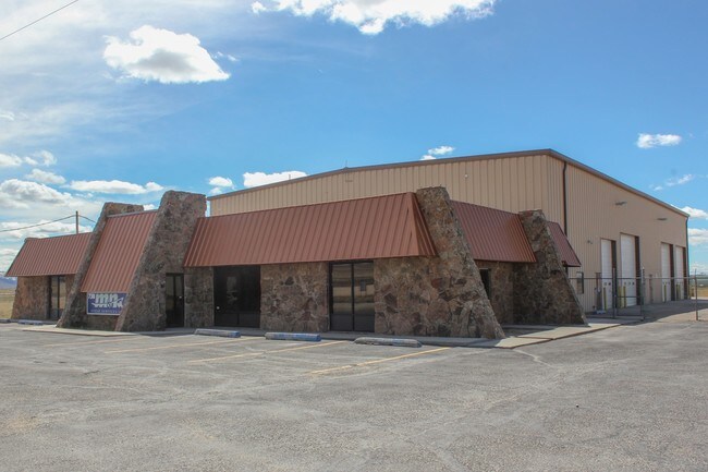
Property Record
738 N Robertson Rd, Casper, WY 82604


NEARBY LISTINGS FOR SALE OR LEASE
Property Detail
738 N Robertson Rd
Casper, WY
Zero Road Ind Pk
33-80-03-1-0-200600
ZERO ROAD IND PK LOT 6 COMMERCIAL
Officebuilding
Natrona
X
Wyoming
56025C1985E
6
2024
5.04 AC
2025
I-25 Corridor/Casper
001700
Other Market Areas
5,120 SF
DEMOGRAPHICS near 738 N Robertson Rd
1 Mile
3 Mile
5 Mile
2024 Total Population
163
11,835
33,326
2029 Population
165
11,880
33,786
Pop Growth 2024-2029
+ 1.23%
+ 0.38%
+ 1.38%
Average Age
46
40
41
2024 Total Households
66
4,625
13,765
HH Growth 2024-2029
+ 1.52%
+ 0.30%
+ 1.41%
Median Household Inc
$96,874
$67,030
$61,835
Avg Household Size
2.40
2.50
2.40
2024 Avg HH Vehicles
3.00
2.00
2.00
Median Home Value
$384,374
$218,594
$220,075
Median Year Built
1977
1979
1972
Nearby Places
Map Layers
Map Styles
 Street
 Aerial
- Restaurants
- Banks
- Shops
- Fitness
- Groceries
PUBLIC TRANSPORTATION
AIRPORT
Casper/Natrona County International
DRIVE
WALK
Distance
Casper/Natrona County International
23 min
10.8 mi
Freight Ports
Tulsa Port Of Catoosa
DRIVE
WALK
Distance
Tulsa Port Of Catoosa
999 min
983.1 mi
SALE & LEASE HISTORY
LISTING DATE
SALE/LEASE

Oct 30, 2017
For Lease
Nearby Properties
Address
Land Use
TOTAL SIZE
Lot Size
Zoning
Address
Land Use
TOTAL SIZE
Lot Size
Zoning
73,903 SF
31.44 AC
Address
Land Use
TOTAL SIZE
Lot Size
Zoning
89,887 SF
5.46 AC
Address
Land Use
TOTAL SIZE
Lot Size
Zoning
88,739 SF
13.39 AC
Address
Land Use
TOTAL SIZE
Lot Size
Zoning
24,240 SF
16.47 AC
Address
Land Use
TOTAL SIZE
Lot Size
Zoning
66,679 SF
5.50 AC
Address
Land Use
TOTAL SIZE
Lot Size
Zoning
25,200 SF
9.68 AC
Address
Land Use
TOTAL SIZE
Lot Size
Zoning
7,500 SF
6.15 AC
Address
Land Use
TOTAL SIZE
Lot Size
Zoning
4,000 SF
12.65 AC
Address
Land Use
TOTAL SIZE
Lot Size
Zoning
59,690 SF
14.68 AC
Address
Land Use
TOTAL SIZE
Lot Size
Zoning
36,000 SF
2.62 AC
Address
Land Use
TOTAL SIZE
Lot Size
Zoning
13,423 SF
28.24 AC
Address
Land Use
TOTAL SIZE
Lot Size
Zoning
800 SF
6.95 AC
Address
Land Use
TOTAL SIZE
Lot Size
Zoning
66,872 SF
9.89 AC
Address
Land Use
TOTAL SIZE
Lot Size
Zoning
28,219 SF
13.96 AC
Address
Land Use
TOTAL SIZE
Lot Size
Zoning
37,635 SF
1.78 AC
Address
Land Use
TOTAL SIZE
Lot Size
Zoning
5,880 SF
25 AC
Address
Land Use
TOTAL SIZE
Lot Size
Zoning
20,600 SF
4.38 AC
Address
Land Use
TOTAL SIZE
Lot Size
Zoning
9,700 SF
120.35 AC
Address
Land Use
TOTAL SIZE
Lot Size
Zoning
49,626 SF
8.43 AC
Address
Land Use
TOTAL SIZE
Lot Size
Zoning
16,000 SF
1.39 AC
Address
Land Use
TOTAL SIZE
Lot Size
Zoning
54,696 SF
9.50 AC
Address
Land Use
TOTAL SIZE
Lot Size
Zoning
9,000 SF
13.59 AC
Address
Land Use
TOTAL SIZE
Lot Size
Zoning
5,028 SF
5.36 AC
Address
Land Use
TOTAL SIZE
Lot Size
Zoning
40,272 SF
10.17 AC
Address
Land Use
TOTAL SIZE
Lot Size
Zoning
14,000 SF
3.21 AC
Address
Land Use
TOTAL SIZE
Lot Size
Zoning
15,090 SF
3.25 AC
Address
Land Use
TOTAL SIZE
Lot Size
Zoning
30,320 SF
3.25 AC
Address
Land Use
TOTAL SIZE
Lot Size
Zoning
28,000 SF
2.50 AC
Address
Land Use
TOTAL SIZE
Lot Size
Zoning
27,922 SF
4.52 AC
Address
Land Use
TOTAL SIZE
Lot Size
Zoning
24,765 SF
2.76 AC
The World's #1 Commercial Real Estate Marketplace
Connect with us
© 2025 CoStar Group
The information above has been obtained from sources believed reliable. While we do not doubt its accuracy we have not verified it and make no guarantee, warranty or representation about it. It is your responsibility to independently confirm its accuracy and completeness. Any projections, opinions, assumptions, or estimates used are for example only and do not represent the current or future performance of the property. The value of this transaction to you depends on tax and other factors which should be evaluated by your tax, financial, and legal advisors. You and your advisors should conduct a careful, independent investigation of the property to determine to your satisfaction the suitability of the property for your needs.