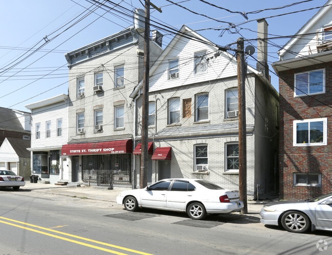
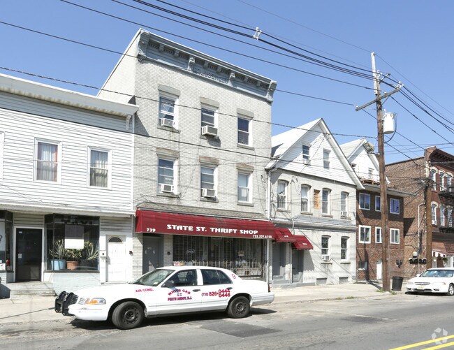
Property Record
739 State St, Perth Amboy, NJ 08861


NEARBY LISTINGS FOR SALE OR LEASE
Property Detail
739 State St
Lakewood-New Brunswick, NJ
Map Of Lands Belonging To Jane E Arnold
16-00360-0000-00015
50X100 16
Retailwithmorethanonenonretailuse
Middlesex
X
New Jersey
34023C0069F
15
2024
0.12 AC
2025
South Edison
004501
Northern New Jersey
6,000 SF
DEMOGRAPHICS near 739 State St
1 Mile
3 Mile
5 Mile
2024 Total Population
29,379
114,624
285,092
2029 Population
28,329
112,153
280,742
Pop Growth 2024-2029
(3.57%)
(2.16%)
(1.53%)
Average Age
36
39
40
2024 Total Households
8,989
39,395
100,300
HH Growth 2024-2029
(3.59%)
(2.07%)
(1.53%)
Median Household Inc
$48,653
$77,555
$89,856
Avg Household Size
3.20
2.80
2.80
2024 Avg HH Vehicles
1.00
2.00
2.00
Median Home Value
$274,119
$405,908
$419,397
Median Year Built
1955
1968
1971
Nearby Places
Map Layers
Map Styles
 Street
 Aerial
- Restaurants
- Banks
- Shops
- Fitness
- Groceries
PUBLIC TRANSPORTATION
COMMUTER RAIL
Perth Amboy (North Jersey Coast Line - NJ Transit Commuter Rail (NJ Transit))
DRIVE
WALK
Distance
Perth Amboy (North Jersey Coast Line - NJ Transit Commuter Rail (NJ Transit))
4 min
1.4 mi
Richmond Valley (Staten Island Railway - New York MTA Subway (The Subway))
DRIVE
WALK
Distance
Richmond Valley (Staten Island Railway - New York MTA Subway (The Subway))
8 min
4.1 mi
AIRPORT
Newark Liberty International
DRIVE
WALK
Distance
Newark Liberty International
32 min
19.5 mi
LaGuardia
DRIVE
WALK
Distance
LaGuardia
60 min
37.1 mi
John F Kennedy International
DRIVE
WALK
Distance
John F Kennedy International
63 min
39.6 mi
Freight Ports
New York Container Terminal
DRIVE
WALK
Distance
New York Container Terminal
21 min
13.0 mi
SALE & LEASE HISTORY
LISTING DATE
SALE/LEASE

Jun 08, 2018
For Lease
Nearby Properties
Address
Land Use
TOTAL SIZE
Lot Size
Zoning
Address
Land Use
TOTAL SIZE
Lot Size
Zoning
37.32 AC
S-3B
Address
Land Use
TOTAL SIZE
Lot Size
Zoning
Address
Land Use
TOTAL SIZE
Lot Size
Zoning
53.04 AC
S-1F
Address
Land Use
TOTAL SIZE
Lot Size
Zoning
11.63 AC
S-3D
Address
Land Use
TOTAL SIZE
Lot Size
Zoning
10.69 AC
R-MM
Address
Land Use
TOTAL SIZE
Lot Size
Zoning
15.15 AC
RMMF
Address
Land Use
TOTAL SIZE
Lot Size
Zoning
71.66 AC
M-3
Address
Land Use
TOTAL SIZE
Lot Size
Zoning
2.51 AC
H
Address
Land Use
TOTAL SIZE
Lot Size
Zoning
28.90 AC
S-3B
Address
Land Use
TOTAL SIZE
Lot Size
Zoning
52.97 AC
M-3
Address
Land Use
TOTAL SIZE
Lot Size
Zoning
64.66 AC
S-3A
Address
Land Use
TOTAL SIZE
Lot Size
Zoning
6.79 AC
R-50
Address
Land Use
TOTAL SIZE
Lot Size
Zoning
38.58 AC
PARK
Address
Land Use
TOTAL SIZE
Lot Size
Zoning
7.23 AC
S-2A
Address
Land Use
TOTAL SIZE
Lot Size
Zoning
27.36 AC
Address
Land Use
TOTAL SIZE
Lot Size
Zoning
6,822 SF
29.22 AC
S-2C
Address
Land Use
TOTAL SIZE
Lot Size
Zoning
39.14 AC
M-3
Address
Land Use
TOTAL SIZE
Lot Size
Zoning
276 SF
6.59 AC
S-2A
Address
Land Use
TOTAL SIZE
Lot Size
Zoning
23.01 AC
S-1F
Address
Land Use
TOTAL SIZE
Lot Size
Zoning
35.05 AC
M-3
Address
Land Use
TOTAL SIZE
Lot Size
Zoning
15,000 SF
16.63 AC
M1-1
Address
Land Use
TOTAL SIZE
Lot Size
Zoning
30.50 AC
Address
Land Use
TOTAL SIZE
Lot Size
Zoning
64.66 AC
S-3A
Address
Land Use
TOTAL SIZE
Lot Size
Zoning
9.72 AC
M-1
Address
Land Use
TOTAL SIZE
Lot Size
Zoning
135,000 SF
4.54 AC
R3X
Address
Land Use
TOTAL SIZE
Lot Size
Zoning
60.44 AC
S-3A
Address
Land Use
TOTAL SIZE
Lot Size
Zoning
317 SF
11.60 AC
R-MM
Address
Land Use
TOTAL SIZE
Lot Size
Zoning
15.55 AC
Address
Land Use
TOTAL SIZE
Lot Size
Zoning
109,000 SF
3.38 AC
R3X
Address
Land Use
TOTAL SIZE
Lot Size
Zoning
21.50 AC
S-3A
The World's #1 Commercial Real Estate Marketplace
Connect with us
© 2026 CoStar Group
The information above has been obtained from sources believed reliable. While we do not doubt its accuracy we have not verified it and make no guarantee, warranty or representation about it. It is your responsibility to independently confirm its accuracy and completeness. Any projections, opinions, assumptions, or estimates used are for example only and do not represent the current or future performance of the property. The value of this transaction to you depends on tax and other factors which should be evaluated by your tax, financial, and legal advisors. You and your advisors should conduct a careful, independent investigation of the property to determine to your satisfaction the suitability of the property for your needs.