Property Record
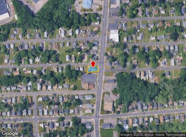
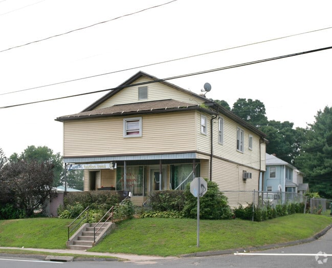
739 Blue Hills Ave, Bloomfield, CT 06002

NEARBY LISTINGS FOR SALE OR LEASE
Property Detail
739 Blue Hills Ave
BLOO-000561-000000-000130-000001
Hartford
Commercialbuilding
Connecticut
X
97
09003C0362F
0.18 AC
2024
Bloomfield
2025
Hartford
471200
Hartford-West Hartford-East Hartford, CT
2,349 SF
DEMOGRAPHICS near 739 Blue Hills Ave
1 Mile
3 Mile
5 Mile
2024 Total Population
10,159
89,296
216,481
2029 Population
10,057
89,166
215,613
Pop Growth 2024-2029
(1.00%)
(0.15%)
(0.40%)
Average Age
38
39
39
2024 Total Households
3,063
34,788
86,438
HH Growth 2024-2029
(1.04%)
(0.06%)
(0.33%)
Median Household Inc
$60,483
$52,708
$58,205
Avg Household Size
2.60
2.30
2.30
2024 Avg HH Vehicles
2.00
1.00
1.00
Median Home Value
$155,871
$230,803
$262,094
Median Year Built
1953
1958
1956
Nearby Places
Map Layers
Map Styles
 Street
 Aerial
- Restaurants
- Banks
- Shops
- Fitness
- Groceries
PUBLIC TRANSPORTATION
COMMUTER RAIL
DRIVE
WALK
Distance
9 min
3.5 mi
DRIVE
WALK
Distance
9 min
3.5 mi
AIRPORT
Bradley International
DRIVE
WALK
Distance
Bradley International
24 min
12.9 mi
Freight Ports
Port of New Haven
DRIVE
WALK
Distance
Port of New Haven
60 min
43.1 mi
Nearby Properties
Address
Land Use
TOTAL SIZE
Lot Size
Zoning
Address
Land Use
TOTAL SIZE
Lot Size
Zoning
88.48 AC
R-10
Address
Land Use
TOTAL SIZE
Lot Size
Zoning
482,566 SF
0.65 AC
DT-2
Address
Land Use
TOTAL SIZE
Lot Size
Zoning
4.13 AC
DT-1
Address
Land Use
TOTAL SIZE
Lot Size
Zoning
1.45 AC
CAMP
Address
Land Use
TOTAL SIZE
Lot Size
Zoning
213,017 SF
6.21 AC
DT-3
Address
Land Use
TOTAL SIZE
Lot Size
Zoning
2.90 AC
DT-2
Address
Land Use
TOTAL SIZE
Lot Size
Zoning
15,871 SF
42.80 AC
PO
Address
Land Use
TOTAL SIZE
Lot Size
Zoning
29.35 AC
CAMP
Address
Land Use
TOTAL SIZE
Lot Size
Zoning
584 AC
OS
Address
Land Use
TOTAL SIZE
Lot Size
Zoning
5.56 AC
CAMP
Address
Land Use
TOTAL SIZE
Lot Size
Zoning
28.02 AC
CAMP
Address
Land Use
TOTAL SIZE
Lot Size
Zoning
68.36 AC
Address
Land Use
TOTAL SIZE
Lot Size
Zoning
416,762 SF
20 AC
CAMP
Address
Land Use
TOTAL SIZE
Lot Size
Zoning
7.45 AC
CAMP
Address
Land Use
TOTAL SIZE
Lot Size
Zoning
227,898 SF
5.33 AC
BCD
Address
Land Use
TOTAL SIZE
Lot Size
Zoning
310,901 SF
28.75 AC
MX-2
Address
Land Use
TOTAL SIZE
Lot Size
Zoning
15.31 AC
DDZ
Address
Land Use
TOTAL SIZE
Lot Size
Zoning
197,704 SF
1.82 AC
CAMP
Address
Land Use
TOTAL SIZE
Lot Size
Zoning
211,308 SF
55.90 AC
R-13
Address
Land Use
TOTAL SIZE
Lot Size
Zoning
40,632 SF
1.10 AC
NX-1
Address
Land Use
TOTAL SIZE
Lot Size
Zoning
772,060 SF
17.90 AC
DDZ
Address
Land Use
TOTAL SIZE
Lot Size
Zoning
23.10 AC
R-20
Address
Land Use
TOTAL SIZE
Lot Size
Zoning
11.85 AC
MX-2
Address
Land Use
TOTAL SIZE
Lot Size
Zoning
172,026 SF
11.64 AC
MX-2
Address
Land Use
TOTAL SIZE
Lot Size
Zoning
10.74 AC
ID-1
Address
Land Use
TOTAL SIZE
Lot Size
Zoning
319,127 SF
2.51 AC
DT-3
Address
Land Use
TOTAL SIZE
Lot Size
Zoning
23.07 AC
CAMP
Address
Land Use
TOTAL SIZE
Lot Size
Zoning
15.39 AC
SDD/RM
Address
Land Use
TOTAL SIZE
Lot Size
Zoning
161,576 SF
4 AC
BCD
Address
Land Use
TOTAL SIZE
Lot Size
Zoning
19.66 AC
CAMP
The World's #1 Commercial Real Estate Marketplace
Connect with us
© 2025 CoStar Group
The information above has been obtained from sources believed reliable. While we do not doubt its accuracy we have not verified it and make no guarantee, warranty or representation about it. It is your responsibility to independently confirm its accuracy and completeness. Any projections, opinions, assumptions, or estimates used are for example only and do not represent the current or future performance of the property. The value of this transaction to you depends on tax and other factors which should be evaluated by your tax, financial, and legal advisors. You and your advisors should conduct a careful, independent investigation of the property to determine to your satisfaction the suitability of the property for your needs.