Property Record
739 County Road 1, South Point, OH 45680

Save to a Folder
{{folder.Name}}
{{folder.ListingIds.length}} Properties
{{folder.ListingIds.length}} Property
Create a New Folder
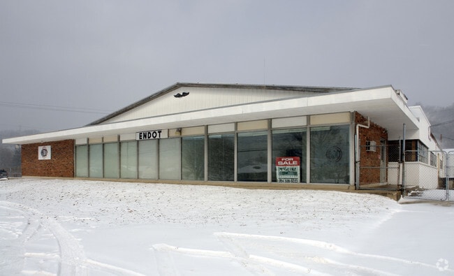
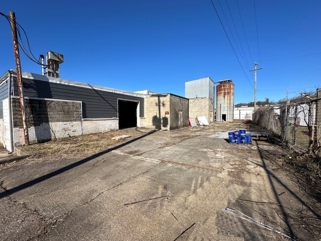
Property Detail
739 County Road 1
Huntington-Ashland, WV-KY-OH
17-02-19 20 2 PT IN W1/2 E OF RD. 0001.40A
15-100-1000-000
Lawrence
Commercialnec
Ohio
B and X Area of moderate flood hazard, usually the area between the limits of the 100-year and 500-year floods.
2
2024
1.40 AC
2025
Lawrence County
051002
Huntington/Ashland
17,456 SF
NEARBY LISTINGS FOR SALE OR LEASE
DEMOGRAPHICS near 739 County Road 1
1 mile
3 mile
5 mile
2025 Total Population
1,382
20,265
45,870
2030 Population
1,360
19,985
45,031
Pop Growth 2025-2030
(1.59%)
(1.38%)
(1.83%)
Average Age
38
41
42
2025 Total Households
579
8,506
19,085
HH Growth 2025-2030
(1.38%)
(1.29%)
(1.79%)
Median Household Inc
$38,293
$51,446
$53,762
Avg Household Size
2.30
2.30
2.30
2025 Avg HH Vehicles
1.00
2.00
2.00
Median Home Value
$132,568
$139,166
$137,428
Median Year Built
1985
1964
1966
Nearby Places
Map Layers
Map Styles
 Street
 Aerial
Layers
 Traffic
 Biking
Places
Listings with unknown addresses are not visible on the map
- Restaurants
- Banks
- Shops
- Fitness
- Groceries
PUBLIC TRANSPORTATION
COMMUTER RAIL
Ashland Amtrak Station (Cardinal - Amtrak)
Drive
Walk
Distance
Ashland Amtrak Station (Cardinal - Amtrak)
6 min
3.6 mi
AIRPORT
Tri-State/Milton J Ferguson Field
Drive
Walk
Distance
Tri-State/Milton J Ferguson Field
27 min
15.5 mi
Freight Ports
Port of Toledo
Drive
Walk
Distance
Port of Toledo
335 min
259.5 mi
SALE & LEASE HISTORY
LISTING DATE
SALE/LEASE

Feb 15, 2024
For Sale
Aug 14, 2023
For Sale
Nearby Properties
Address
Land Use
TOTAL SIZE
Lot Size
Zoning
Address
Land Use
TOTAL SIZE
Lot Size
Zoning
6.96 AC
Z02
Address
Land Use
TOTAL SIZE
Lot Size
Zoning
36.49 AC
OTHER
Address
Land Use
TOTAL SIZE
Lot Size
Zoning
0.99 AC
Z02
Address
Land Use
TOTAL SIZE
Lot Size
Zoning
16.29 AC
COMMERCIAL
Address
Land Use
TOTAL SIZE
Lot Size
Zoning
116,640 SF
0.97 AC
COMMERCIAL
Address
Land Use
TOTAL SIZE
Lot Size
Zoning
91,786 SF
2.93 AC
Address
Land Use
TOTAL SIZE
Lot Size
Zoning
123,920 SF
6.81 AC
Address
Land Use
TOTAL SIZE
Lot Size
Zoning
0.73 AC
Z02
Address
Land Use
TOTAL SIZE
Lot Size
Zoning
0.82 AC
COMMERCIAL
Address
Land Use
TOTAL SIZE
Lot Size
Zoning
1.67 AC
RESIDENTIA
Address
Land Use
TOTAL SIZE
Lot Size
Zoning
141 AC
COMMERCIAL
Address
Land Use
TOTAL SIZE
Lot Size
Zoning
47,107 SF
4.67 AC
Address
Land Use
TOTAL SIZE
Lot Size
Zoning
8,364 SF
3 AC
Z02
Address
Land Use
TOTAL SIZE
Lot Size
Zoning
1.46 AC
COMMERCIAL
Address
Land Use
TOTAL SIZE
Lot Size
Zoning
0.21 AC
Z02
Address
Land Use
TOTAL SIZE
Lot Size
Zoning
3.50 AC
Z02
Address
Land Use
TOTAL SIZE
Lot Size
Zoning
1,920 SF
33.30 AC
Z03
Address
Land Use
TOTAL SIZE
Lot Size
Zoning
0.57 AC
COMMERCIAL
Address
Land Use
TOTAL SIZE
Lot Size
Zoning
126,716 SF
10.60 AC
Address
Land Use
TOTAL SIZE
Lot Size
Zoning
16,632 SF
1.07 AC
COMMERCIAL
Address
Land Use
TOTAL SIZE
Lot Size
Zoning
1 AC
COMMERCIAL
Address
Land Use
TOTAL SIZE
Lot Size
Zoning
54.65 AC
Address
Land Use
TOTAL SIZE
Lot Size
Zoning
66,600 SF
1.35 AC
OTHER
Address
Land Use
TOTAL SIZE
Lot Size
Zoning
4 AC
Z01
Address
Land Use
TOTAL SIZE
Lot Size
Zoning
0.48 AC
COMMERCIAL
Address
Land Use
TOTAL SIZE
Lot Size
Zoning
96,405 SF
1.40 AC
COMMERCIAL
Address
Land Use
TOTAL SIZE
Lot Size
Zoning
1.60 AC
COMMERCIAL
Address
Land Use
TOTAL SIZE
Lot Size
Zoning
65,904 SF
6.10 AC
Address
Land Use
TOTAL SIZE
Lot Size
Zoning
27,084 SF
3.73 AC
Address
Land Use
TOTAL SIZE
Lot Size
Zoning
0.49 AC
COMMERCIAL
The World's #1 Commercial Real Estate Marketplace
Connect with us
© 2026 CoStar Group
The information above has been obtained from sources believed reliable. While we do not doubt its accuracy we have not verified it and make no guarantee, warranty or representation about it. It is your responsibility to independently confirm its accuracy and completeness. Any projections, opinions, assumptions, or estimates used are for example only and do not represent the current or future performance of the property. The value of this transaction to you depends on tax and other factors which should be evaluated by your tax, financial, and legal advisors. You and your advisors should conduct a careful, independent investigation of the property to determine to your satisfaction the suitability of the property for your needs.