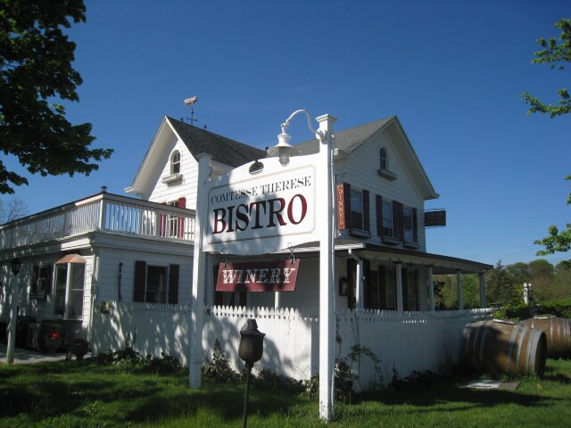
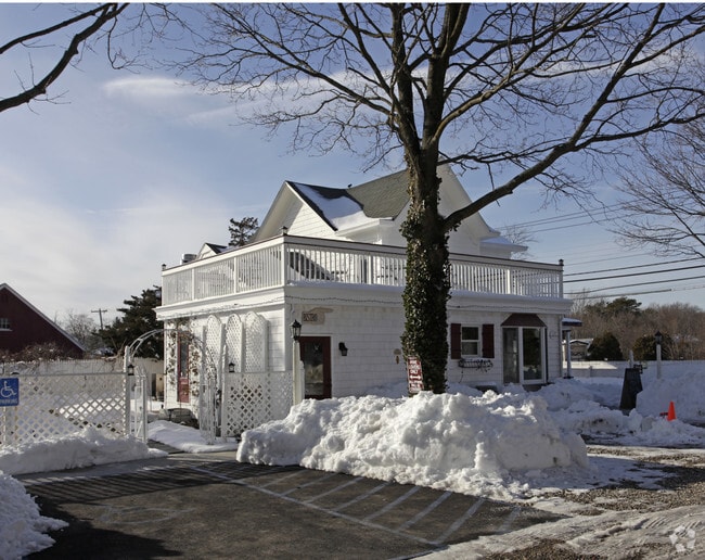
Property Record
739 E Main Rd, Laurel, NY 11948

Property Detail
739 E Main Rd
0600-067-00-02-00-027-000
N X MAIN RD E X SCHRIEFERS & W X BERTOLI
Restaurantbuilding
SUFFOLK
04
New York
B and X Area of moderate flood hazard, usually the area between the limits of the 100-year and 500-year floods.
27
2024
0.46 AC
2025
Eastern Suffolk
170003
Long Island (New York)
2,285 SF
Nassau County-Suffolk County, NY
NEARBY LISTINGS FOR SALE OR LEASE
DEMOGRAPHICS near 739 E Main Rd
1 mile
3 mile
5 mile
2025 Total Population
1,306
18,562
35,746
2030 Population
1,283
18,592
36,070
Pop Growth 2025-2030
(1.76%)
+ 0.16%
+ 0.91%
Average Age
45
42
43
2025 Total Households
483
6,558
12,937
HH Growth 2025-2030
(2.07%)
(0.29%)
+ 0.61%
Median Household Inc
$139,705
$94,121
$88,376
Avg Household Size
2.60
2.70
2.60
2025 Avg HH Vehicles
3.00
2.00
2.00
Median Home Value
$693,798
$553,706
$545,233
Median Year Built
1981
1982
1982
Nearby Places
Map Layers
Map Styles
 Street
 Aerial
Layers
 Traffic
 Biking
Places
Listings with unknown addresses are not visible on the map
- Restaurants
- Banks
- Shops
- Fitness
- Groceries
PUBLIC TRANSPORTATION
COMMUTER RAIL
Riverhead Station (Greenport Branch - Long Island Rail Road)
Drive
Walk
Distance
Riverhead Station (Greenport Branch - Long Island Rail Road)
8 min
3.6 mi
Mattituck Station (Greenport Branch - Long Island Rail Road)
Drive
Walk
Distance
Mattituck Station (Greenport Branch - Long Island Rail Road)
11 min
6.0 mi
AIRPORT
Long Island MacArthur
Drive
Walk
Distance
Long Island MacArthur
50 min
32.2 mi
Nearby Properties
Address
Land Use
TOTAL SIZE
Lot Size
Zoning
Address
Land Use
TOTAL SIZE
Lot Size
Zoning
51.70 AC
R15
Address
Land Use
TOTAL SIZE
Lot Size
Zoning
8,100 SF
4.31 AC
LI40
Address
Land Use
TOTAL SIZE
Lot Size
Zoning
222 AC
H2O
Address
Land Use
TOTAL SIZE
Lot Size
Zoning
151,290 SF
6.17 AC
08
Address
Land Use
TOTAL SIZE
Lot Size
Zoning
81.70 AC
R60
Address
Land Use
TOTAL SIZE
Lot Size
Zoning
16,699 SF
24.81 AC
03
Address
Land Use
TOTAL SIZE
Lot Size
Zoning
108,504 SF
31.20 AC
SC
Address
Land Use
TOTAL SIZE
Lot Size
Zoning
3,468 SF
17.70 AC
CR60
Address
Land Use
TOTAL SIZE
Lot Size
Zoning
113,634 SF
27.49 AC
04
Address
Land Use
TOTAL SIZE
Lot Size
Zoning
28.97 AC
R40
Address
Land Use
TOTAL SIZE
Lot Size
Zoning
73,651 SF
8.50 AC
3
Address
Land Use
TOTAL SIZE
Lot Size
Zoning
139,515 SF
12.30 AC
03
Address
Land Use
TOTAL SIZE
Lot Size
Zoning
14,520 SF
21.20 AC
04
Address
Land Use
TOTAL SIZE
Lot Size
Zoning
274.40 AC
05
Address
Land Use
TOTAL SIZE
Lot Size
Zoning
15.40 AC
RA40
Address
Land Use
TOTAL SIZE
Lot Size
Zoning
19,179 SF
0.74 AC
08
Address
Land Use
TOTAL SIZE
Lot Size
Zoning
3,676 SF
2 AC
VB
Address
Land Use
TOTAL SIZE
Lot Size
Zoning
4.20 AC
R10
Address
Land Use
TOTAL SIZE
Lot Size
Zoning
8,996 SF
1.70 AC
LI40
Address
Land Use
TOTAL SIZE
Lot Size
Zoning
5,406 SF
2.74 AC
LI40
Address
Land Use
TOTAL SIZE
Lot Size
Zoning
43,840 SF
1.87 AC
3
Address
Land Use
TOTAL SIZE
Lot Size
Zoning
23,108 SF
2.63 AC
3
Address
Land Use
TOTAL SIZE
Lot Size
Zoning
12,988 SF
1.01 AC
R15
Address
Land Use
TOTAL SIZE
Lot Size
Zoning
6.03 AC
SC
Address
Land Use
TOTAL SIZE
Lot Size
Zoning
13.47 AC
R40
Address
Land Use
TOTAL SIZE
Lot Size
Zoning
29.93 AC
RA80
Address
Land Use
TOTAL SIZE
Lot Size
Zoning
2,679 SF
0.78 AC
VB
Address
Land Use
TOTAL SIZE
Lot Size
Zoning
67,350 SF
6.80 AC
03
Address
Land Use
TOTAL SIZE
Lot Size
Zoning
21.30 AC
H2O
Address
Land Use
TOTAL SIZE
Lot Size
Zoning
3,906 SF
1.28 AC
4
The World's #1 Commercial Real Estate Marketplace
Connect with us
© 2026 CoStar Group
The information above has been obtained from sources believed reliable. While we do not doubt its accuracy we have not verified it and make no guarantee, warranty or representation about it. It is your responsibility to independently confirm its accuracy and completeness. Any projections, opinions, assumptions, or estimates used are for example only and do not represent the current or future performance of the property. The value of this transaction to you depends on tax and other factors which should be evaluated by your tax, financial, and legal advisors. You and your advisors should conduct a careful, independent investigation of the property to determine to your satisfaction the suitability of the property for your needs.