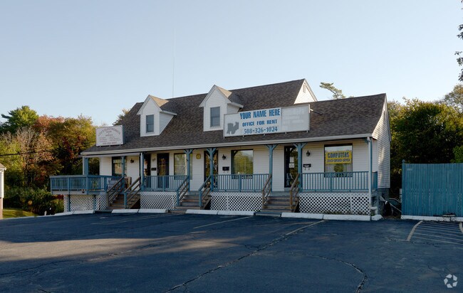
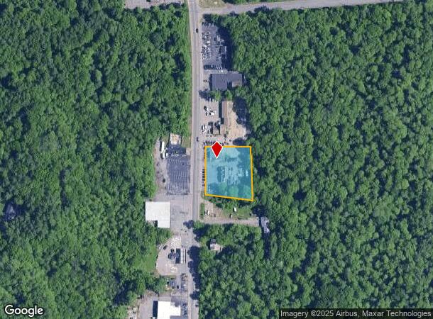
Property Record
739 N Main St, West Bridgewater, MA 02379

NEARBY LISTINGS FOR SALE OR LEASE
-
-
-
-
-
No Photo
-
-
View all West Bridgewater listings for sale on LoopNet.com
Property Detail
739 N Main St
WBRI-000018-000000-000114
Plymouth
Commercialnec
Massachusetts
X
114
25023C0167J
0.94 AC
2020
Route 3 South
2025
Boston
524102
Boston-Cambridge-Newton, MA-NH
728 SF
DEMOGRAPHICS near 739 N Main St
1 Mile
3 Mile
5 Mile
2024 Total Population
3,628
49,749
146,464
2029 Population
3,613
49,101
145,242
Pop Growth 2024-2029
(0.41%)
(1.30%)
(0.83%)
Average Age
43
39
39
2024 Total Households
1,354
16,365
50,227
HH Growth 2024-2029
(0.52%)
(1.34%)
(0.89%)
Median Household Inc
$109,342
$85,924
$83,428
Avg Household Size
2.60
2.90
2.70
2024 Avg HH Vehicles
2.00
2.00
2.00
Median Home Value
$422,817
$392,344
$394,923
Median Year Built
1960
1954
1962
Nearby Places
Map Layers
Map Styles
 Street
 Aerial
- Restaurants
- Banks
- Shops
- Fitness
- Groceries
PUBLIC TRANSPORTATION
COMMUTER RAIL
Campello (Middleborough/Lakeville Line - Massachusetts Bay Transportation Authority Commuter Rail (Purple Line))
DRIVE
WALK
Distance
Campello (Middleborough/Lakeville Line - Massachusetts Bay Transportation Authority Commuter Rail (Purple Line))
4 min
1.8 mi
Brockton (Middleborough/Lakeville Line - Massachusetts Bay Transportation Authority Commuter Rail (Purple Line))
DRIVE
WALK
Distance
Brockton (Middleborough/Lakeville Line - Massachusetts Bay Transportation Authority Commuter Rail (Purple Line))
6 min
3.4 mi
AIRPORT
General Edward Lawrence Logan International
DRIVE
WALK
Distance
General Edward Lawrence Logan International
44 min
29.1 mi
Freight Ports
Port of Boston
DRIVE
WALK
Distance
Port of Boston
42 min
26.9 mi
Nearby Properties
Address
Land Use
TOTAL SIZE
Lot Size
Zoning
Address
Land Use
TOTAL SIZE
Lot Size
Zoning
95.27 AC
R1C
Address
Land Use
TOTAL SIZE
Lot Size
Zoning
1,352 SF
66.81 AC
R1B
Address
Land Use
TOTAL SIZE
Lot Size
Zoning
47.64 AC
100
Address
Land Use
TOTAL SIZE
Lot Size
Zoning
412,500 SF
48.94 AC
100
Address
Land Use
TOTAL SIZE
Lot Size
Zoning
733 SF
16.41 AC
R1C
Address
Land Use
TOTAL SIZE
Lot Size
Zoning
3,088 SF
1.38 AC
C3
Address
Land Use
TOTAL SIZE
Lot Size
Zoning
3,438 SF
1.15 AC
C2
Address
Land Use
TOTAL SIZE
Lot Size
Zoning
223,200 SF
5.26 AC
C2
Address
Land Use
TOTAL SIZE
Lot Size
Zoning
21.12 AC
Address
Land Use
TOTAL SIZE
Lot Size
Zoning
88,957 SF
0.57 AC
R2
Address
Land Use
TOTAL SIZE
Lot Size
Zoning
4,074 SF
3.82 AC
R3
Address
Land Use
TOTAL SIZE
Lot Size
Zoning
130,640 SF
10.27 AC
R1C
Address
Land Use
TOTAL SIZE
Lot Size
Zoning
3,812 SF
0.64 AC
C3
Address
Land Use
TOTAL SIZE
Lot Size
Zoning
558,011 SF
82.11 AC
Address
Land Use
TOTAL SIZE
Lot Size
Zoning
67.01 AC
Address
Land Use
TOTAL SIZE
Lot Size
Zoning
2,884 SF
3.18 AC
R2
Address
Land Use
TOTAL SIZE
Lot Size
Zoning
1,217 SF
13.79 AC
R1C
Address
Land Use
TOTAL SIZE
Lot Size
Zoning
210,600 SF
19.86 AC
Address
Land Use
TOTAL SIZE
Lot Size
Zoning
463,305 SF
116.22 AC
100
Address
Land Use
TOTAL SIZE
Lot Size
Zoning
647 SF
53.67 AC
I3
Address
Land Use
TOTAL SIZE
Lot Size
Zoning
22.54 AC
C2
Address
Land Use
TOTAL SIZE
Lot Size
Zoning
312,000 SF
30.61 AC
Address
Land Use
TOTAL SIZE
Lot Size
Zoning
2,574 SF
7.96 AC
I1
Address
Land Use
TOTAL SIZE
Lot Size
Zoning
69,184 SF
7.90 AC
100
Address
Land Use
TOTAL SIZE
Lot Size
Zoning
Address
Land Use
TOTAL SIZE
Lot Size
Zoning
211,030 SF
19.27 AC
Address
Land Use
TOTAL SIZE
Lot Size
Zoning
207,654 SF
14.17 AC
R1C
Address
Land Use
TOTAL SIZE
Lot Size
Zoning
1,844 SF
14 AC
R1C
Address
Land Use
TOTAL SIZE
Lot Size
Zoning
80,429 SF
16.68 AC
Address
Land Use
TOTAL SIZE
Lot Size
Zoning
1,374 SF
7.82 AC
C2
The World's #1 Commercial Real Estate Marketplace
Connect with us
© 2025 CoStar Group
The information above has been obtained from sources believed reliable. While we do not doubt its accuracy we have not verified it and make no guarantee, warranty or representation about it. It is your responsibility to independently confirm its accuracy and completeness. Any projections, opinions, assumptions, or estimates used are for example only and do not represent the current or future performance of the property. The value of this transaction to you depends on tax and other factors which should be evaluated by your tax, financial, and legal advisors. You and your advisors should conduct a careful, independent investigation of the property to determine to your satisfaction the suitability of the property for your needs.