Property Record
739 Nevil Rd, Winlock, WA 98596

Save to a Folder
{{folder.Name}}
{{folder.ListingIds.length}} Properties
{{folder.ListingIds.length}} Property
Create a New Folder
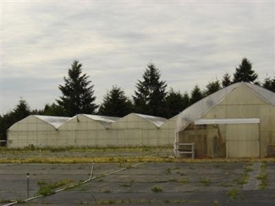
Property Detail
739 Nevil Rd
015391-006-002
SECTION 27 TOWNSHIP 12N RANGE 02W W 343 E 686 NW4 SE4 N RD
Wholesaleoutletdiscountstore
LEWIS
ARL
Washington
2024
4.96 AC
2025
Washington State Area
971501
Other Market Areas
67,200 SF
Centralia, WA
NEARBY LISTINGS FOR SALE OR LEASE
-
-
View all Winlock listings for sale on LoopNet.com
DEMOGRAPHICS near 739 Nevil Rd
1 mile
3 mile
5 mile
2025 Total Population
1,334
5,206
8,795
2030 Population
1,400
5,443
9,089
Pop Growth 2025-2030
+ 4.95%
+ 4.55%
+ 3.34%
Average Age
42
42
43
2025 Total Households
492
1,928
3,258
HH Growth 2025-2030
+ 4.88%
+ 4.51%
+ 3.28%
Median Household Inc
$73,219
$73,647
$73,832
Avg Household Size
2.70
2.70
2.70
2025 Avg HH Vehicles
3.00
3.00
3.00
Median Home Value
$388,349
$395,220
$415,391
Median Year Built
1986
1987
1986
Nearby Places
Map Layers
Map Styles
 Street
 Aerial
Layers
 Traffic
 Biking
Places
Listings with unknown addresses are not visible on the map
- Restaurants
- Banks
- Shops
- Fitness
- Groceries
Nearby Properties
Address
Land Use
TOTAL SIZE
Lot Size
Zoning
Address
Land Use
TOTAL SIZE
Lot Size
Zoning
1,976 SF
69.39 AC
LI
Address
Land Use
TOTAL SIZE
Lot Size
Zoning
Address
Land Use
TOTAL SIZE
Lot Size
Zoning
104.79 AC
Address
Land Use
TOTAL SIZE
Lot Size
Zoning
93.72 AC
LI
Address
Land Use
TOTAL SIZE
Lot Size
Zoning
Address
Land Use
TOTAL SIZE
Lot Size
Zoning
Address
Land Use
TOTAL SIZE
Lot Size
Zoning
1,260 SF
71 AC
LI
Address
Land Use
TOTAL SIZE
Lot Size
Zoning
Address
Land Use
TOTAL SIZE
Lot Size
Zoning
Address
Land Use
TOTAL SIZE
Lot Size
Zoning
Address
Land Use
TOTAL SIZE
Lot Size
Zoning
50,575 SF
40 AC
PF
Address
Land Use
TOTAL SIZE
Lot Size
Zoning
0.83 AC
RDD5
Address
Land Use
TOTAL SIZE
Lot Size
Zoning
Address
Land Use
TOTAL SIZE
Lot Size
Zoning
4,032 SF
4 AC
PF
Address
Land Use
TOTAL SIZE
Lot Size
Zoning
6,228 SF
125.03 AC
ARL
Address
Land Use
TOTAL SIZE
Lot Size
Zoning
Address
Land Use
TOTAL SIZE
Lot Size
Zoning
60,000 SF
3.77 AC
LI
Address
Land Use
TOTAL SIZE
Lot Size
Zoning
13,641 SF
4.99 AC
RDD20
Address
Land Use
TOTAL SIZE
Lot Size
Zoning
18,380 SF
1.08 AC
MDR
Address
Land Use
TOTAL SIZE
Lot Size
Zoning
2,040 SF
46.07 AC
ARL
Address
Land Use
TOTAL SIZE
Lot Size
Zoning
Address
Land Use
TOTAL SIZE
Lot Size
Zoning
9.22 AC
Address
Land Use
TOTAL SIZE
Lot Size
Zoning
3,713 SF
3.94 AC
C2
Address
Land Use
TOTAL SIZE
Lot Size
Zoning
Address
Land Use
TOTAL SIZE
Lot Size
Zoning
3,332 SF
301.39 AC
ARL
Address
Land Use
TOTAL SIZE
Lot Size
Zoning
2,372 SF
31.31 AC
Address
Land Use
TOTAL SIZE
Lot Size
Zoning
4,260 SF
32.21 AC
ARL
Address
Land Use
TOTAL SIZE
Lot Size
Zoning
Address
Land Use
TOTAL SIZE
Lot Size
Zoning
4,866 SF
20 AC
RDD5
The World's #1 Commercial Real Estate Marketplace
Connect with us
© 2026 CoStar Group
The information above has been obtained from sources believed reliable. While we do not doubt its accuracy we have not verified it and make no guarantee, warranty or representation about it. It is your responsibility to independently confirm its accuracy and completeness. Any projections, opinions, assumptions, or estimates used are for example only and do not represent the current or future performance of the property. The value of this transaction to you depends on tax and other factors which should be evaluated by your tax, financial, and legal advisors. You and your advisors should conduct a careful, independent investigation of the property to determine to your satisfaction the suitability of the property for your needs.