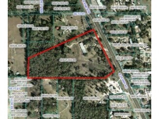
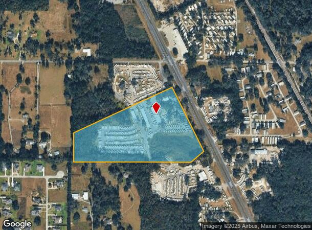
Property Record
7392 S Us Highway 441, Ocala, FL 34480
NEARBY LISTINGS FOR SALE OR LEASE
Property Detail
7392 S Us Highway 441
36547-002-00
SEC 10 TWP 16 RGE 22 BEGINNING AT SE COR OF N 1/2 OF SW 1/4 TH S 89-40-20-W 1571.56 FT TH N-0-3-20 W 401.48 FT TH N-65-17-50 E 1451.88 FT TO INTERSECTION SWLY RWY 441 BEING S 26-57-10 E 376.62 FT FROM N BDY & SWLY RWY TH S-26-57-10 E ALONG RWY LINE 9
Storebuilding
Marion
X
Florida
12083C0730D
26.63 AC
2024
Outlying Marion County
2024
Ocala
002302
Ocala, FL
15,844 SF
DEMOGRAPHICS near 7392 S Us Highway 441
1 Mile
3 Mile
5 Mile
2024 Total Population
1,542
19,660
72,321
2029 Population
1,745
22,254
81,722
Pop Growth 2024-2029
+ 13.16%
+ 13.19%
+ 13.00%
Average Age
42
40
41
2024 Total Households
603
7,448
27,691
HH Growth 2024-2029
+ 13.10%
+ 13.13%
+ 12.90%
Median Household Inc
$61,415
$70,543
$65,314
Avg Household Size
2.50
2.60
2.50
2024 Avg HH Vehicles
2.00
2.00
2.00
Median Home Value
$220,290
$235,418
$213,725
Median Year Built
1986
1990
1988
Nearby Places
Map Layers
Map Styles
 Street
 Aerial
- Restaurants
- Banks
- Shops
- Fitness
- Groceries
Nearby Properties
Address
Land Use
TOTAL SIZE
Lot Size
Zoning
Address
Land Use
TOTAL SIZE
Lot Size
Zoning
364,073 SF
119.27 AC
A1
Address
Land Use
TOTAL SIZE
Lot Size
Zoning
211,884 SF
80 AC
GU
Address
Land Use
TOTAL SIZE
Lot Size
Zoning
64,086 SF
28.11 AC
A1
Address
Land Use
TOTAL SIZE
Lot Size
Zoning
680,069 SF
62.96 AC
B5
Address
Land Use
TOTAL SIZE
Lot Size
Zoning
60,710 SF
66.65 AC
A1
Address
Land Use
TOTAL SIZE
Lot Size
Zoning
82,124 SF
20 AC
A1
Address
Land Use
TOTAL SIZE
Lot Size
Zoning
62,076 SF
51.58 AC
A1
Address
Land Use
TOTAL SIZE
Lot Size
Zoning
83,881 SF
16.60 AC
A1
Address
Land Use
TOTAL SIZE
Lot Size
Zoning
268,493 SF
18.70 AC
M2
Address
Land Use
TOTAL SIZE
Lot Size
Zoning
540 AC
A1
Address
Land Use
TOTAL SIZE
Lot Size
Zoning
501 SF
428.83 AC
B4
Address
Land Use
TOTAL SIZE
Lot Size
Zoning
65,444 SF
12.17 AC
M1
Address
Land Use
TOTAL SIZE
Lot Size
Zoning
28,134 SF
12.27 AC
B2
Address
Land Use
TOTAL SIZE
Lot Size
Zoning
75,000 SF
20.66 AC
M1
Address
Land Use
TOTAL SIZE
Lot Size
Zoning
93,120 SF
34.47 AC
PUD
Address
Land Use
TOTAL SIZE
Lot Size
Zoning
33,519 SF
154.74 AC
R1
Address
Land Use
TOTAL SIZE
Lot Size
Zoning
68,186 SF
6.20 AC
B5
Address
Land Use
TOTAL SIZE
Lot Size
Zoning
50,776 SF
12.05 AC
B2
Address
Land Use
TOTAL SIZE
Lot Size
Zoning
98,428 SF
10 AC
M2
Address
Land Use
TOTAL SIZE
Lot Size
Zoning
23,865 SF
90.97 AC
GU
Address
Land Use
TOTAL SIZE
Lot Size
Zoning
28,081 SF
10 AC
R1
Address
Land Use
TOTAL SIZE
Lot Size
Zoning
34,277 SF
14.94 AC
B5
Address
Land Use
TOTAL SIZE
Lot Size
Zoning
11,144 SF
20.84 AC
B2
Address
Land Use
TOTAL SIZE
Lot Size
Zoning
60,978 SF
6.88 AC
PUD
Address
Land Use
TOTAL SIZE
Lot Size
Zoning
40,000 SF
4.06 AC
M1
Address
Land Use
TOTAL SIZE
Lot Size
Zoning
6,709 SF
133.58 AC
A1
Address
Land Use
TOTAL SIZE
Lot Size
Zoning
9,687 SF
118.25 AC
B5
Address
Land Use
TOTAL SIZE
Lot Size
Zoning
37,765 SF
7.23 AC
B2
Address
Land Use
TOTAL SIZE
Lot Size
Zoning
310 AC
A1
Address
Land Use
TOTAL SIZE
Lot Size
Zoning
61,369 SF
10.69 AC
M2
The World's #1 Commercial Real Estate Marketplace
Connect with us
© 2025 CoStar Group
The information above has been obtained from sources believed reliable. While we do not doubt its accuracy we have not verified it and make no guarantee, warranty or representation about it. It is your responsibility to independently confirm its accuracy and completeness. Any projections, opinions, assumptions, or estimates used are for example only and do not represent the current or future performance of the property. The value of this transaction to you depends on tax and other factors which should be evaluated by your tax, financial, and legal advisors. You and your advisors should conduct a careful, independent investigation of the property to determine to your satisfaction the suitability of the property for your needs.