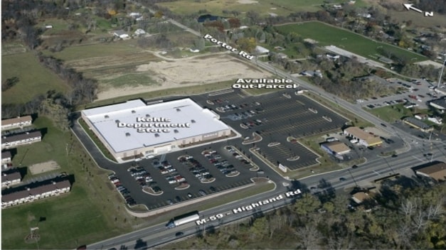
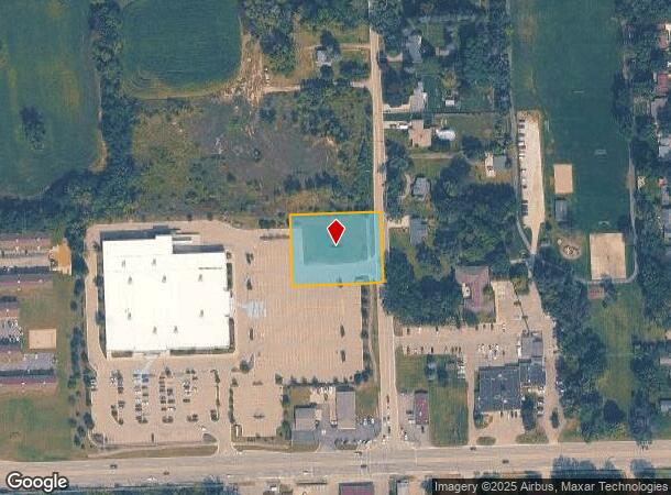
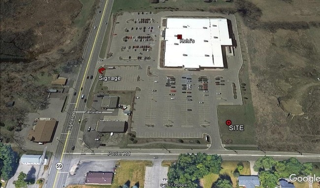
Property Record
7395 Highland Rd, White Lake, MI 48383

NEARBY LISTINGS FOR SALE OR LEASE
Property Detail
7395 Highland Rd
12-21-100-073
T3N, R8E, SEC 21 PART OF E 1/2 OF NW 1/4 BEG AT PT DIST N 00-23-40 W 475 FT FROM CEN OF SEC, TH S 89-52-13 W 238 FT, TH N 00-23-40 W 185 FT, TH N 89-52-13 E 238 FT, TH S 00-23-40 E 185 FT TO BEG 1.01 A 12-06-06 FR 035 & 036
Commercialacreage
Oakland
X
Michigan
26125C0319F
1.01 AC
2024
St Clair & Lapeer Counties
2024
Detroit
130100
Detroit-Warren-Dearborn, MI
DEMOGRAPHICS near 7395 Highland Rd
1 Mile
3 Mile
5 Mile
2024 Total Population
2,255
22,477
69,069
2029 Population
2,233
22,295
68,491
Pop Growth 2024-2029
(0.98%)
(0.81%)
(0.84%)
Average Age
43
43
42
2024 Total Households
879
8,742
26,844
HH Growth 2024-2029
(0.91%)
(0.81%)
(0.83%)
Median Household Inc
$87,769
$93,781
$95,780
Avg Household Size
2.50
2.50
2.50
2024 Avg HH Vehicles
2.00
2.00
2.00
Median Home Value
$326,724
$307,672
$306,532
Median Year Built
1976
1981
1981
Nearby Places
Map Layers
Map Styles
 Street
 Aerial
- Restaurants
- Banks
- Shops
- Fitness
- Groceries
PUBLIC TRANSPORTATION
AIRPORT
Bishop International
DRIVE
WALK
Distance
Bishop International
56 min
38.3 mi
Freight Ports
Port of Toledo
DRIVE
WALK
Distance
Port of Toledo
104 min
81.7 mi
SALE & LEASE HISTORY
LISTING DATE
SALE/LEASE

Sep 25, 2016
For Lease
Nearby Properties
Address
Land Use
TOTAL SIZE
Lot Size
Zoning
Address
Land Use
TOTAL SIZE
Lot Size
Zoning
4,260 SF
101.34 AC
MM
Address
Land Use
TOTAL SIZE
Lot Size
Zoning
4,011 SF
53.71 AC
MM
Address
Land Use
TOTAL SIZE
Lot Size
Zoning
3,908 SF
54.90 AC
MM
Address
Land Use
TOTAL SIZE
Lot Size
Zoning
207,282 SF
55.01 AC
BI
Address
Land Use
TOTAL SIZE
Lot Size
Zoning
119,755 SF
14.03 AC
Address
Land Use
TOTAL SIZE
Lot Size
Zoning
156,808 SF
13.11 AC
PB
Address
Land Use
TOTAL SIZE
Lot Size
Zoning
92,821 SF
12.19 AC
BI
Address
Land Use
TOTAL SIZE
Lot Size
Zoning
71,627 SF
13 AC
BV
Address
Land Use
TOTAL SIZE
Lot Size
Zoning
42,467 SF
13.70 AC
Address
Land Use
TOTAL SIZE
Lot Size
Zoning
49,726 SF
12.83 AC
BV
Address
Land Use
TOTAL SIZE
Lot Size
Zoning
113,668 SF
10.73 AC
PB
Address
Land Use
TOTAL SIZE
Lot Size
Zoning
65,345 SF
5.69 AC
GB
Address
Land Use
TOTAL SIZE
Lot Size
Zoning
88,540 SF
9.07 AC
PB
Address
Land Use
TOTAL SIZE
Lot Size
Zoning
103,525 SF
8.33 AC
PB
Address
Land Use
TOTAL SIZE
Lot Size
Zoning
23,300 SF
3.99 AC
BI
Address
Land Use
TOTAL SIZE
Lot Size
Zoning
291.23 AC
ROS
Address
Land Use
TOTAL SIZE
Lot Size
Zoning
17,603 SF
2.41 AC
Address
Land Use
TOTAL SIZE
Lot Size
Zoning
29,295 SF
15.15 AC
AI
Address
Land Use
TOTAL SIZE
Lot Size
Zoning
15.74 AC
MM
Address
Land Use
TOTAL SIZE
Lot Size
Zoning
19,097 SF
6.04 AC
GB
Address
Land Use
TOTAL SIZE
Lot Size
Zoning
12,000 SF
1.43 AC
BI
Address
Land Use
TOTAL SIZE
Lot Size
Zoning
11,400 SF
1.44 AC
Address
Land Use
TOTAL SIZE
Lot Size
Zoning
24,027 SF
2.10 AC
BV
Address
Land Use
TOTAL SIZE
Lot Size
Zoning
3,720 SF
4.91 AC
LB
Address
Land Use
TOTAL SIZE
Lot Size
Zoning
38,008 SF
4 AC
BI
Address
Land Use
TOTAL SIZE
Lot Size
Zoning
12,601 SF
2.54 AC
BI
Address
Land Use
TOTAL SIZE
Lot Size
Zoning
6,318 SF
109.88 AC
FI
Address
Land Use
TOTAL SIZE
Lot Size
Zoning
29,143 SF
9.62 AC
BI
Address
Land Use
TOTAL SIZE
Lot Size
Zoning
10,859 SF
2.70 AC
GB
Address
Land Use
TOTAL SIZE
Lot Size
Zoning
5,522 SF
1.74 AC
BV
The World's #1 Commercial Real Estate Marketplace
Connect with us
© 2025 CoStar Group
The information above has been obtained from sources believed reliable. While we do not doubt its accuracy we have not verified it and make no guarantee, warranty or representation about it. It is your responsibility to independently confirm its accuracy and completeness. Any projections, opinions, assumptions, or estimates used are for example only and do not represent the current or future performance of the property. The value of this transaction to you depends on tax and other factors which should be evaluated by your tax, financial, and legal advisors. You and your advisors should conduct a careful, independent investigation of the property to determine to your satisfaction the suitability of the property for your needs.